Denton / Downtown,
Courthouse Square Historic District & Area
legend - Denton
/ Downtown, Courthouse Square Historic District
& Area
- John B. Denton
- The City of Denton
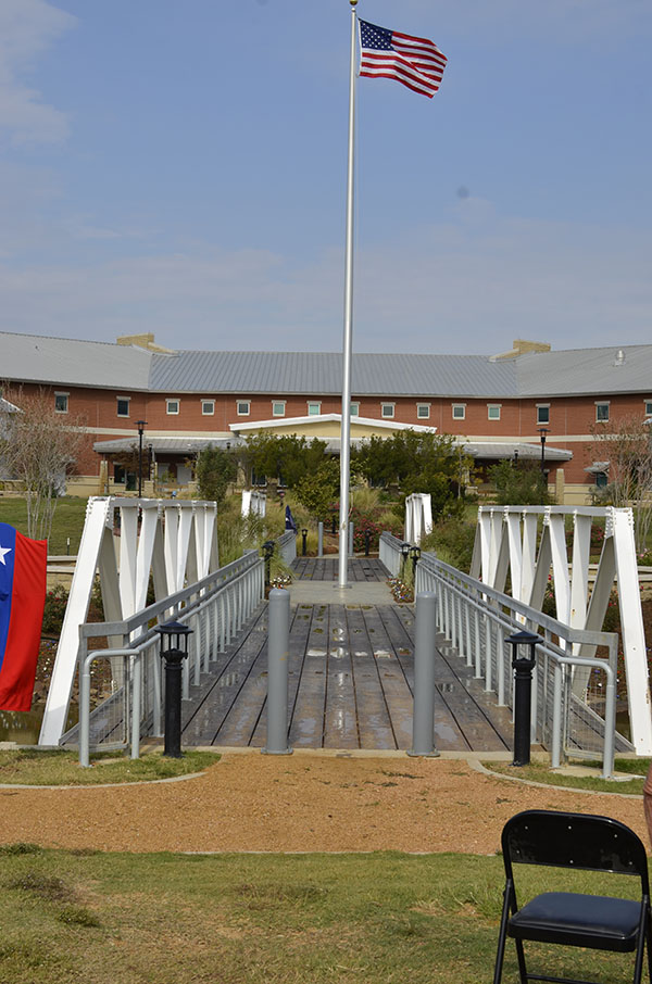
- Confederate Memorial
- Denton County Courthouse
- Lacy Hotel
- Denton County
- Texas Normal College
- Denton Courthouse Square Historic District
- First United Methodist Church, Denton
- John B. Denton College Bell
- O'Neil Ford
- Bayless-Selby House Museum
- Campus Theatre
- Quakertown
- Quakertown House
- Edna Westbrook Trigg
- Beulah A. Harriss
- Denton 1927 City Hall
|
|
| Type: |
Texas Centennial Marker, 1936
|
| Location: |
courthouse lawn corner of Locust and West Hickory Streets, Denton. |
| Marker Text: |
Born in Tennessee July 26, 1806, came to Texas in January, 1836. As a Methodist
circuit rider killed in the Village Creek Indian fight May 24, 1841 in what is
now Tarrant County. Named for Gen. Edward H. Tarrant who commanded the
volunteers. Denton city and county were named for the pioneer lawyer, preacher,
soldier of that name. |
| Pictures: |
    |
|
back to top
|
| Type: |
THC Subject Marker, 1977
|
| Location: |
courthouse lawn, corner of Locust and West Hickory Streets, next to John B.
Denton grave, Denton. |
| Marker Text: |
Pioneers settled this locality in the 1840's. In 1846 the Texas Legislature
created Denton County -- one of several carved from the Peters Colony grant.
After trying other sites, the voters in 1856 accepted for county seat this tract
donated by Hiram Cisco, William Loving, and William Woodruff. The city and
county were named for John B. Denton (1806-41), a minister killed while
defending frontier settlers. Woodruff, fellow surveyor C. C. Lacy, and attorney
Otis Welch platted the townsite. In 1857 city lots were auctioned, the post
office opened, and a church was founded. J. M. Blount, Joseph A. Carroll, W. F.
Egan, and I. D. Ferguson were pioneer leaders. A cotton gin and plants for
making bricks, corn meal, flour and ice soon developed. The "Monitor," a
newspaper, began its career in 1868. Sam Bass (1851-78), legendary western
outlaw, trained and raced "The Denton Mare" while living and working as a local
farm hand. North Texas State University originated here as Texas Normal College
in 1890, and Texas Woman's University opened in 1903 as the College of
Industrial Arts. Agriculture-related businesses, education, and small factories
sustain the economy. The city grew from 1,194 in its first census (1880) to
39,874 by 1970. (1977) |
| Pictures: |
     |
|
back to top
|
| Type: |
Non-state approved, 1918.
|
| Location: |
courthouse lawn, 110 West Hickory Street, south sidewalk entrance, Denton. |
| Marker Text: |
Erected by Daughters of the Confederacy in memory of our soldiers in heroic
self-sacrifice and devoted loyalty gave their manhood and their lives to the
South in her hour of need. (Inscription on front of monument) In Memoriam "Their
names graved on memorial columns are a song heard far in the future; and their
examples reach a hand through all the years to meet and kindle generous purposes
and mold it into acts as pure as theirs." |
| Pictures: |
    |
|
back to top
|
| Type: |
THC Recorded Texas Historic Landmark, 1970;
Listed in the National Register of Historic Places, 1977
|
| Location: |
Attached to northeast corner of courthouse at West Oak and Locust Streets,
Denton. |
| Marker Text: |
Built 1896-97. Fifth courthouse for Denton County. First was at Alton, second at
Pinckneyville. Third (in Denton) was burned in crime charged to a member of the
Sam Bass Gang of outlaws. Walls are native limestone; columns, Burnet County
marble. Architecture is free combination of Victorian styles, with French second
empire pavilions, fanciful ogival domes. Architect was W. C. Dodson; contractor
Tom Lovell is said to have built Utah Capitol.
Recorded Texas Historic Landmark, 1970. Entered in the National Register of
Historic Places, 1977.
|
Historical Narrative: |
Denton County Courthouse |
| Pictures: |
     |
|
back to top
|
| Type: |
THC Subject Marker, 1973
|
| Location: |
102 West Oak Street, attached to the Texas Building, Denton. |
| Marker Text: |
Charles Christian Lacy (1816 - 70) moved with wife Sarah (Brown) from Kentucky
to Texas, 1854; platted Denton townsite, 1855; had what is thought to have been
city's first hotel, existent 1858-82, at this site. Before he gained fame as
bandit, Sam Bass worked here briefly as a livery stable boy. |
| Historical Narrative: |
Historical Narrative |
| Pictures: |
    |
|
|
| Type: |
Texas Centennial Marker, 1936
|
| Location: |
courthouse lawn, corner of Elm and West Oak Streets (originally placed as a
highway marker in Argyle, US 377), Denton. |
| Marker Text: |
Created April 11, 1846 from Fannin County; organized July 13, 1846 with Denton
as county seat. Both town and county are named in honor of John B. Denton
1806-1841. Pioneer preacher, lawyer and Indian fighter. First county seat
designated as Pinckneyville, 1846. Site selected in 1848 called Alton
permanently located at Denton in 1857. |
| Pictures: |
    |
|
back to top
|
| Type: |
THC Subject Marker, 1965
|
| Location: |
northwest corner of courthouse square, corner of Elm and West Oak (attached to
furniture bldg. across street from courthouse), Denton. |
| Marker Text: |
At this site, on the second floor of a hardware store, 70 students enrolled for
the first session of Texas Normal College and Teacher Training Institute,
September 16, 1890. The students included 28 Creeks from Indian territory. The
city of Denton provided classrooms for the faculty of five under president
Joshua C. Chilton, an educator with previous experience and training in Ohio and
Indiana. In 1891, the school moved to a building at the present site of North
Texas State University. This marker dedicated on 75th Anniversary of the
University. (1965) |
| Pictures: |
   |
|
back to top
|
| Type: |
National Register of Historic Places
|
| Location: |
Denton County Courthouse located in center of courthouse square; area bounded by Pecan, Austin, Walnut and Cedar Streets, Denton |
| Marker Text: |
Not available at this time. |
| Pictures: |
Not available at this time. |
|
|
| Type: |
THC Subject Marker, 1996
|
| Location: |
201 South Locust Street, Denton. |
| Marker Text: |
The Rev. William E. Bates organized the First Methodist Church of Denton in
1857, the same year the town of Denton was formed. Services were conducted in
the log courthouse until the Masonic Lodge of Denton constructed a 2-story
building in 1859. It served as a school and meeting hall and was used by all the
area churches. In 1873 the Methodist congregation built their first meeting
house, which was a white frame church with a steeple and bell. Funds for a red
brick sanctuary built in 1899 were raised in part at a revival conducted by
evangelist Abe Mulkey. By 1907 the congregation of more than 600 members had
outgrown its sanctuary, but another building was not constructed until 1925 when
a new church building with a seating capacity of 2,400 was completed. An
education building was added in 1951, and other renovations have taken place
over the years. Many prominent citizens of Denton have been members of this
church which has provided a variety of programs for the congregation and has
supported local and foreign missions. It has served the community through
several social outreach activities and continues to be an integral part of the
Denton area. (1996) |
Historical Narrative: |
First Methodist Church of Denton |
| Pictures: |
    |
|
|
| Type: |
Denton County Historical Commission Foundation,
1984
|
| Location: |
201 South Locust Street, First Methodist Church, Denton. |
| Marker Text: |
Placed by the Denton County Historical Commission Foundation. Placed in memory
of Henry G. (Pete) Shands. Dedicated in honor of all children of First United
Methodist Church, June 1984 |
| Pictures: |
  |
|
|
| Type: |
THC Subject Marker, 2008
|
| Location: |
502 Oakland Street, Emily Fowler Central Library, Denton. |
| Marker Text: |
(December 3, 1905 - July 20, 1982) In the mid-20th century, a North Texas native
became a leading architect of the American Southwest. O'Neil Ford was born in
Pink Hill and went to school in Sherman (both Grayson Co.), where the arts and
crafts curriculum inspired his entire family. Following the death of his father,
the Fords moved to Denton. O'Neil learned drafting, woodworking, and
architectural drawing at North Texas State Teachers College and earned an
architectural certificate by mail from the International Correspondence School
of Scranton (Pa.). At the College of Industrial Arts he read the school
library's architectural journals, and on the construction site of Denton
Presbyterian Church O'Neil met Dallas architect David Williams, who became his
mentor. In partnership with others since 1932, Ford designed several significant
projects, including Little Chapel in the Woods in Denton, restoration of La
Villita in San Antonio, major portions of the campuses of Trinity University
(San Antonio) and Skidmore College (Saratoga Springs, N.Y.), and the Tower of
the Americas for the Hemisfair in San Antonio. He integrated architectural
designs with their settings by collaborating with craftsmen and artists, and was
active in historic preservation and environmental causes. Ford designed
municipal buildings, churches, libraries and homes during his career. He
designed additions to Denton's Emily Fowler Library in 1969 and 1981,
incorporating a courtyard and interior finishes handcrafted by his family. Ford
was named a Fellow of the American Institute of Architects in 1960 and appointed
by President Lyndon Johnson to serve on the National Council for the Arts. His
legacy lives on in the artistic blends of natural materials, clean lines, and
open spaces in his designs. (2008) |
Historical Narrative: |
O'Neil Ford Historical Narrative |
| Pictures: |
          |
|
back to top
|
| Type: |
DCHC Marker, 2005
|
| Location: |
317 West Mulberry Street and Carroll Boulevard in Historical Park of Denton
County, Denton. |
| Marker Text: |
Samuel A. Bayless and his wife, Mary, came to Denton from Monroe County,
Tennessee. In 1884, he purchased a two-room farmhouse, the one-story part of the
museum. Later, they built a two story Victorian Queen Anne-style addition.
Samuel died in 1919. Mary sold the house in 1920 to R.L. Selby Sr. and his wife,
Mary. The Selby family retained ownership until 1970. The house was moved from
1301 Myrtle Street, Denton in 1998. After restoration, the house opened as the
Bayless-Selby House Museum in 2001. |
| Historical Narrative: |
Bayless-Selby House Museum |
| Pictures: |
     |
|
|
| Type: |
THC Recorded Texas Historic Landmark, 2009
|
| Location: |
214 West Hickory Street, Denton. |
| Marker Text: |
The Campus Theatre was built in 1949 by
Interstate Theatres and served as one of three cinemas owned by the company in
Denton until its final use as a cinematic theater in 1985. Original manager J.P.
Harrison was well-known for both. his business acumen and his civic involvement.
The Campus Theatre, designed by the Dallas Architectural firm of
Pettigrew-Worley & Co., was built in the Art Moderne style typical of post-WWII
theaters and features geometric embellishments, such as a stepped parapet, a
tapered vertical fin sign and a curvilinear canopy with geometric neon
ornamentation.
Recorded Texas Historic Landmark-2009, Marker is Property of the State of Texas |
| Historical Narrative: |
Campus Theatre Historical Narrative |
| Pictures: |
    |
|
| Type: |
THC Subject Marker, 2011
|
| Location: |
Quakertown Park, west of Civic Center at 321 East McKinney Street, Denton. |
| Marker Text: |
In the early 1880s, Quakertown emerged as a thriving African American community in the heart of Denton. Quakertown flourished through 1920, its growth due in part to its location near the city square and the opportunities it provided African Americans. The community was bounded by Withers Street on the north, Oakland Avenue on the west, Bell Avenue on the east, and by Cottonwood and Pecan Creeks on the south. Although many residents worked for businesses on the nearby city square, at the College of Industrial Arts (now Texas Woman's University), and as servants for white households, Quakertown prospered as a self-supporting community. Several churches, a physician's office, lodges, restaurants, and small businesses joined homes to line the streets of the community. The neighborhood school, the Fred Douglass School, burned in Sep. 1913 and was rebuilt along Wye Street in southeast Denton in 1916, foreshadowing events to come.
By 1920, the proximity of Quakertown to the growing college of industrial arts and civic-minded interests of Denton's white residents threatened the future of Quakertown. Many believed that it was in the best interest of the college and the Denton community to transform Quakertown into a city park. In Apr. 1921, with little input from its residents, the city voted 367 to 240 in favor of a bond to purchase Quakertown. More than 60 families lost their homes. The majority of the displaced residents relocated to southeast Denton on 21 acres of land, platted as Solomon Hill, sold to them by rancher Albert L. Miles. Others, including many Quakertown community leaders, chose to leave Denton altogether. By Feb. 1923, Quakertown had disappeared in the midst of the new park's construction. (2010) Marker is Property of the State of Texas |
Historical Narrative: |
Quakertown Historical Narrative |
| Pictures: |
       |
|
back to top
|
| Type: |
DCHC Marker, 2008
|
| Location: |
317 West Mulberry Street and Carroll Boulevard in Historical Park of Denton
County, Denton. The Denton County African American Museum is located inside the
Quakertown House. |
| Marker Text: |
Built in 1904 by H. F. Davidson at 607 Bell Ave. in the African American
community of Quakertown, this house was purchased by C. Ross Hembry in 1919. He
sold the land to the City of Denton for $2,700 in 1922 and moved the structure
to 1113 E. Hickory, in Solomon Hill, now Southeast Denton, when the citizens of
Denton voted to make the area a park and remove the entire neighborhood. In
2004, the house was moved to this Park and dedicated as the Denton County
African American Museum on February 16, 2008. |
| Pictures: |
   |
|
back to top
|
| Type: |
THC Subject Marker 2015
|
| Location: |
NE corner Denton County Courthouse-on-the-Square, 110 W. Hickory Street, Denton |
| Marker Text: |
Edna Westbrook trigg (1868-1946) was the first county home
demonstration agent appointed in texas in 1915, serving Denton
county from February 1916 through December 1937. She
was named Denton county home demonstration emeritus
from January 1, 1938 until her retirement on July 31 , 1945 . Previously
in milam county, she served as rural high school
principal and "collaborator" for the united states department
of agriculture as supervisor of girls tomato clubs .
Trigg traveled throughout Denton county teaching and advising
farm women on vegetable gardening, canning, sewing ,
cooking, household management and other aspects of daily
life. She had to overcome prejudices against government's
interference in farming and a woman's interference in a
man's work and home life . During world war i, she helped to
make the county agriculturally self-sufficient by working
with farmers to grow more vegetables, attended patriotic
meetings three nights a week urging people to purchase liberty
bonds and held Saturday canning schools to show rural
residents how to properly preserve and protect the
food they grew. she convinced county commissioners to
loan her $350 to purchase twenty community steam canners
for use in the precincts. the hawkeye demonstration club,
organized in 1919 in the now extinct community of hawkeye,
owned the first community canner. Trigg served on the
staff of the college of industrial arts (texas woman's university)
overseeing courses in the methods of home demonstration
and was honored in 1971 by the texas extension education
association, inc . 4-h with a scholarship in her name.
on October 18, 1991, Edna Westbrook trigg was entered into
the national agricultural center and hall of fame.
(2015) |
Historical Narrative: |
Edna Westbrook Trigg Historical Narrative
Narrative 2
Narrative 3 |
| Pictures: |
  |
|
back to top
|
| Type: |
THC Subject Marker, 2014
|
| Location: |
Quakertown Park, west of Civic Center at 321 E. McKinney Street, Denton |
| Marker Text: |
Beulah a. Harriss (1889-1977) moved to Denton in 1914 from Nebraska to become the first women's physical education teacher at North Texas State Normal College, now University of North Texas (UMT). With a degree from the University of Nebraska in physical education, Harriss coached the university's first women's athletic teams and instructed every sport except football. She organized the physical education department in 1918, which grew under her direction, and the Green Jackets Club, whose purpose was to support all activities of the college.
Harriss was a founder in 1923 of the Texas State Physical Education Association (now Texas Association of Health, Physical Education, Recreation and Dance), serving as president in 1933. She was also a founder of the Texas Woman's Athletic Association in 1924. Established in 1928 at UNT, Harriss was one of twelve charter members of the Rho Chapter of Delta Psi Kappa, a national fraternity for the promotion of interests in the field of physical education. She was named honorary national president in 1960. The first recognized Girl Scout in Texas, Harriss started the first troop at the College in Denton in 1917. She helped build the scout lodge at Hills and Hollows in south Denton in 1923. Harriss and 12 other professors from the college were charter members of the Denton County Teachers Federal Credit Union in 1936, now DATCU.
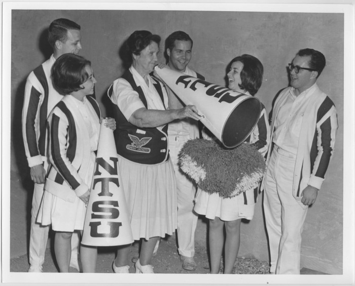
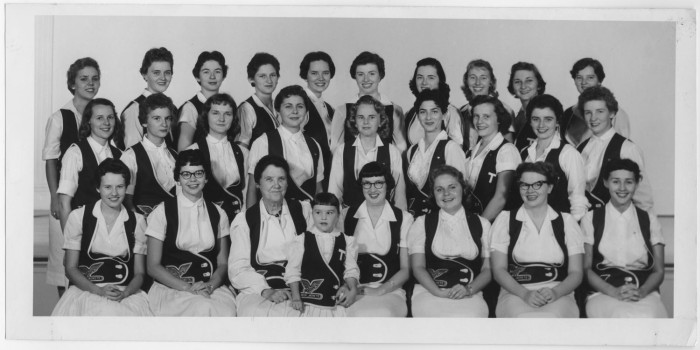
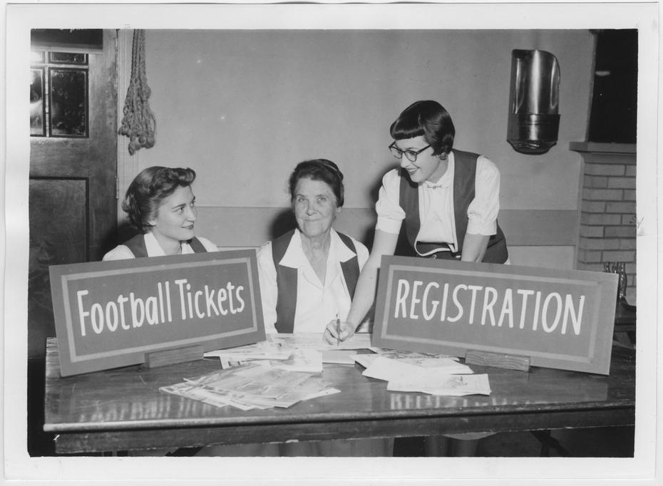
After 46 years at UNT as a teacher and women’s athletics activist, Harriss retired in 1960. She was inducted into the North Texas Athletic Hall of fame in 1987, 10 years after her death. Harriss devoted her life to the youth and citizens of Denton and is remembered each February 27th on Beulah Harriss day. The Girl Scout little house stood near this site. (2014) Marker is Property of the State of Texas |
Historical Narrative: |
Beulah Harriss Historical Narrative |
| Pictures: |
          |
|
|
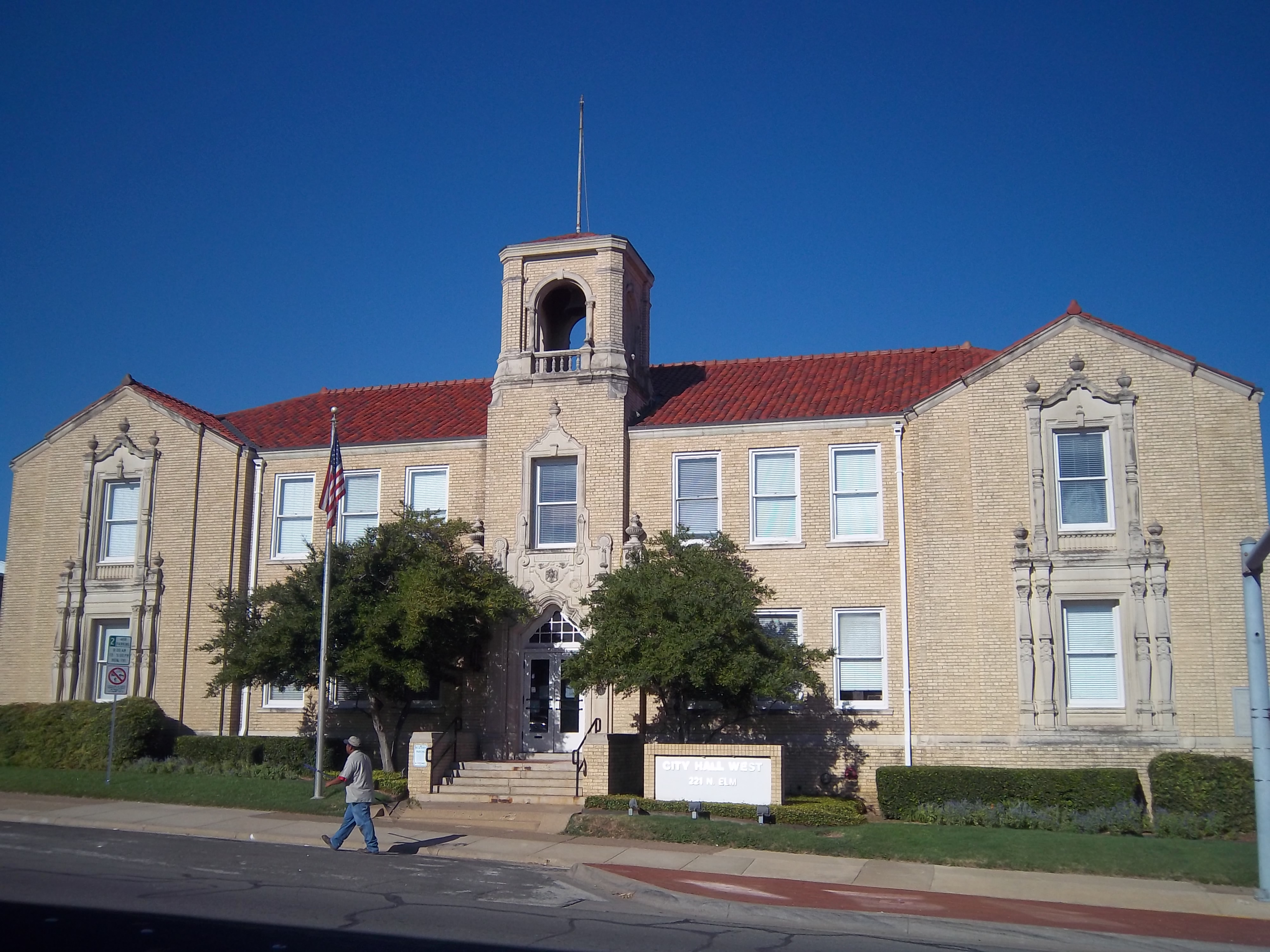
| Type: |
THC Recorded Texas Historical Landmark, 2015
|
| Location: |
221 North Elm Street, Denton |
| Marker Text: |
From 1894 until October 1927, the Denton city hall was housed in an 1877 red brick building located
at the corner of oak and bolivar streets. The rapid growth of Denton in the early 20th century called
for a newer and more spacious building. In 1927, a new city hall was designed by the prominent fort
worth architectural firm vanslyke and woodruff in the spanish renaissance style, a very popular
style in the southwest during the twenties. Reminiscent of south texas missions, the white brick
building with ornamental stone embellishments, arched windows and tiled roof has two stories and
a basement. the original plan included a belfry to hold the fire alarm bell because the fire station
occupied the rear area of the building.
This arrangement lasted through the 1970s until a new fire station was built near the city hall.
Governor Dan Moody, Mayor B.W. Mckenzie and other local and state dignitaries attended the
dedication ceremony on October 8, 1927.
In 1969, city offices moved to the O'Neil Ford-designed municipal complex which consisted of the civic
center, municipal pool, library expansion, and city hall, located in Civic Center Park (now Quakertown
Park) on Mckinney Street. in 1970, the Denton community theatre moved into the old city hall and used
the auditorium for performances. This facility was called the "firehouse theatre" and occupied the
space until 1981 when the city decided to move the police department into the building. interior
renovations began jn 1982 . The city hall was known for its annual Christmas decorations that started
in the late 1920s and continued through the 1960s, attracting thousands of viewers each Christmas
season. |
Historical Narrative: |
Denton 1927 City Hall Building Historical Narrative |
| Pictures: |
       |
|
Denton / University of North Texas, Oak-Hickory Historic District and Area
legend - Denton
/ University of North Texas, Historic District &
Area
1. Martin-Russell House
2. Scripture-Deavenport
House
3. Denton Senior
High School
4. First
University Building
5. Historical
Building
6. Rayzor Graham
House
7.
First Christian Church of Denton
8. James Newton
and Eva Tabor Rayzor House
9. I.O.O.F.
Cemetery
10. Immaculate
Conception Catholic Church
11. First
Baptist Church of Denton
12. North Texas State Fair and Rodeo
13.
Christal House
14. Simmons-Maxwell House
15. Mounts-Wright House
16.
Robert Mounts House
17. Lipscomb-Doggett House
18. County Line Road
Bridge at Denton Creek
19. Evers House
|
|
| Type: |
THC Recorded Texas Historic Landmark, 2007
|
| Location: |
811 West Oak Street, Denton. |
| Marker Text: |
This prominent residence was built in 1925-27 at a cost of $30,000 for Dr. M.L.
Martin (1869-1941) and his wife, Ailsey (Forester) Martin (1890-1968). Ailsey
grew up on the nearby Forester Ranch (established 1852) and received one-third
of the ranch of the famous "Two-I-Jinglebob" brand when it was divided in 1913.
Dr. Martin was born in South Carolina and received degrees from Peabody College
(Nashville, TN) in 1892 and the University of Texas at Austin in 1899. He served
in the medical corps during World War I and was a doctor in Denton for forty
years until his death. Pilot Point native James Holford Russell and wife, Ava
Lee (Mars) Russell, bought this property in 1945. J.H. Russell earned a degree
from the University of Texas at Austin in 1919 and for decades managed Russell's
Department Store, part of a family business that debuted in Denton in 1925. He
was also a civic leader and Texas Woman's University Regent. The Russells lived
here until 1967. Fort Worth architect J.B. Davies designed the house, with H.F.
Davidson as carpenter and Charles N. Davis in charge of brick and concrete work.
The home has an attic and basement and 14 rooms, with a sun parlor, living room,
dining room, breakfast room, kitchen and reception hall on the first floor, and
four bedrooms, a sleeping porch, library and two bathrooms upstairs. Prominent
features of the Georgian Revival style house include its red brick veneer and
white stone trim, green-tinted metal tile roof with dormers, arched windows with
keystones, pedimented entryway door surround, wrought iron balconies and
symmetrical massing. Since its construction, the house has been the scene of
numerous social and community events.
Recorded Texas Historic Landmark - 2007. Marker is Property of State of Texas. |
Historical Narrative: |
Martin-Russell House |
| Pictures: |
    |
|
|
| Type: |
THC Recorded Texas Historic Landmark, 1980
|
| Location: |
819 West Oak Street, Denton. |
| Marker Text: |
The original part of this house was built in 1885-86 for local grocer Robert C.
Scripture and his wife Annie (Brown). It was later owned by Robert Hann, a
merchant and civic leader. Constructed as a Victorian residence, it was
remodeled and enlarged about 1912 during the ownership of banker B. H.
Deavenport. The mission revival changes were completed by M. B. Whitlock, a
local contractor, and feature a decorative rose window on the third floor.
Recorded Texas Historic Landmark - 1980 |
| Historical Narrative: |
Scripture Deavenport House |
| Pictures: |
      |
|
|
| Type: |
THC Recorded Texas Historic Landmark, 2009
|
| Location: |
709 Congress Street, Denton. |
| Marker Text: |
The first free city of Denton School opened in 1884. After the building burned
in 1908, another school was built at the same site. When John B. Denton
College closed in 1912, high school students were moved to the former
college building, which sat on a 10.7 acre campus. This red brick building
was constructed in 1924 on the north end of the college campus and opened in
the fall with an enrollment of 478 senior high school students; junior high
classes remained in the old John B. Denton building. Amos O'Neil "Prof:
Calhoun, (1891-1973, principal of the school in the old John B. Denton
building moved to the new structure to become principal when it opened. He
held the post for the next 33 years, retiring at the end of the 1956-57
school year. Calhoun was the only principal to serve during the building's
time as a senior high school. When a new high school on Fulton Street opened
in 1957, this building became Denton Junior High School. The name was
changed to Congress Junior High in 1969 and was again changed in 1982 to
Calhoun Junior High, in honor of its former principal. The campus became a
middle school in 1992. The building has continued in use with additional
wings. Fort Worth architect Wiley G. Clarkson designed this imposing
three-story Classical Revival style schoolhouse, with 24 classrooms,
offices, laboratories, an auditorium, a gymnasium, and a library. The
symmetrical main façade is divided into five bays by a projection central
entry and corner piers. The exterior is brick with Lueders limestone trim. A
central flight of stairs leads to the second-story entrance, and the words
"Senior High School" are inscribed into the stone over the central bay.
Recorded Texas Historic Landmark, 2009, Marker is Property of the State of
Texas. |
| Historical Narrative: |
Denton Senior High School Historical Narrative |
| Pictures: |
      |
|
|
| Type: |
THC Subject Marker, 1965
|
| Location: |
1417 West Hickory Street, at the Ave B. entrance of Hickory Hall, University of
North Texas, Denton. |
| Marker Text: |
On this site in 1891, the city of Denton erected a building to be leased to
President Joshua C. Chilton, for the use of the privately owned Texas Normal
College and Teacher Training Institute, which he had opened the year before in a
business building downtown. The 10-acre campus became state property in 1901.
President Chilton's college thus was forerunner of North Texas State University.
The old Normal building was struck by lightning and burned, 1907. This marker is
dedicated on the 75th anniversary of the beginning of the university. |
| Pictures: |
   |
|
|
| Type: |
THC Subject Marker, 1994
|
| Location: |
200 Avenue A ( corner of Ave. A and Mulberry Street), University of North Texas, Denton. Historical Building is called Curry Hall by UNT |
| Marker Text: |
Built in 1912-13 to serve as a library and gymnasium, this is the oldest
remaining building on the North Texas campus. It became known as the Historical
Building in 1925, when history professor Joseph Lyman Kingsbury (1880-1949)
began a museum that was housed here until 1986. The institution's eclectic
collection included published works and artifacts from around the world. Upon
the museum's closing the collection was distributed to other institutions in
Denton. The building also has housed academic offices, classrooms, and the
College Radio Station. (1994) |
Historical Narrative: |
Historical Building Curry Hall |
| Pictures: |
     |
|
|
| Type: |
THC Recorded Texas Historic Landmark, 1989
|
| Location: |
928 West Hickory Street, Denton. |
| Marker Text: |
Business and civic leader J. Fred Rayzor (1890-1965) had this home constructed
in 1912 by local builder M. T. Goodwin. It was purchased in 1941 by W. E. Graham
(1890-1963) and remained in his family until 1974. Features of the one-story
American foursquare home include bungalow details in the door, columns, and
windows. Also of note are the central entry in the deep attached porch, a hipped
dormer, and washboard siding. Recorded Texas Historic Landmark - 1989 |
| Historical Narrative: |
Rayzor Graham House |
| Pictures: |
      |
|
|
| Type: |
THC Subject Marker, 1997
|
| Location: |
1203 North Fulton Street, Denton. |
| Marker Text: |
This congregation, established in 1868 and led by Elder Terrell Jasper,
initially met in the local Masonic Hall until a frame church building was
erected in 1876. A state charter was issued to First Christian Church of Denton
in 1902. By 1904 a brick building was constructed at Hickory and Piner streets,
the first of three structures to house the congregation at that location. The
current facility at 1203 Fulton Street was designed by O'Neil Ford and was
completed in 1959. The church continues to provide spiritual leadership in the
community. (1997) |
Historical Narrative: |
First Christian Church Of Denton |
| Pictures: |
     |
|
back to top
|
| Type: |
THC Recorded Texas Historic Landmark, 2012
|
| Location: |
1003 West Oak Street, Denton |
| Marker Text: |
James Newton Rayzor was born December 10, 1858 in Lockport, Kentucky. He immigrated to Texas in the fall of 1866 with his family and settled in Collin County. In 1871, the family moved to Cooke County where Rayzor later taught school at Prairie Grove and at Pilot Point and Mustang Community in Denton County. He moved to Denton in 1882 and married Eva Tabor, who was born May 18, 1864 in Pilot Point. Rayzor was involved in many business ventures including the Alliance Mill (now Morrison Milling Co.), Alliance Ice Company and Rayzor Ice Company. He was active in community organizations such as the Masonic Lodge, served as President of the Denton Chamber of Commerce, was a member of the John B. Denton College Committee that founded the School in 1901 and helped establish the State Industrial School for Girls (now Texas Woman's University). Rayzor served as a deacon at the First Baptist Church for 44 years and also authored several books about religion, history and his 1923 travels to Europe and the Holy land. James and Eva purchased the property in 1906 and completed the home in 1909 with contractor M.T. Goodwin. This prairie style home features horizontal lines, exaggerated overhanging eaves and a hipped roof over the send-story bedrooms. Ribbons of windows line the south and southeast side of the home, and repetitive millwork and tongue and groove oak floors complement the interior. The screened sleeping porch contained numerous beds for company and the family during hot summers. After James and Eva passed away in 1938 and 1939, respectively, their descendants owned the home until 1978. Recorded Texas Historic Landmark
- 2012
Marker is Property of the State of Texas |
Historical Narrative: |
James Newton and Eva Tabor Rayzor House Historical Narrative |
| Pictures: |
        |
back to top
|
| Type: |
THC Subject Marker 1996; Historic Texas
Cemetery Marker, 2000
|
| Location: |
Carroll Boulevard, and Eagle Drive, main entrance on Carroll Boulevard, Denton. |
| Marker Text: |
Denton Lodge No. 82 of the Independent Order of Odd Fellows (I.O.O.F.) was
chartered in 1859 by a number of the area's most prominent settlers, including
John S. Chisum of the Chisum Trail fame. That year I.O.O.F. charter member and
Denton merchant James M. Smoot (1822-1862) donated land here for graveyard
purposes. The lodge subdivided the cemetery into four sections, each of which
contained 350 burial plots. The first recorded burial was that of Anne Isabella
Carroll, infant daughter of Joseph and Celia Carroll, in 1860. The site served
as Denton's main graveyard and by the early 1880s space had become scarce. In
1883 the lodge enlarged the cemetery by 7.5 acres acquired from adjacent
landowners John and Ann McMurray; 6.5 acres acquired from the McMurrays in 1916
further enlarged the cemetery. By the early 1920s burial space was again
limited, and in 1924 the cemetery was enlarged by four acres. After maintaining
the cemetery for more than 60 years the lodge deeded the 22-acre site to the
city of Denton in 1933. Among the approximately 5,800 people buried here are
pioneer Denton County settlers, local and state elected officials, and veterans
of wars ranging from the Texas Revolution to World War II. (1996) |
Historical Narrative: |
IOOF Cemetery |
| Pictures: |
      |
|
|
| Type: |
THC Subject Marker, 1994
|
| Location: |
2255 North Bonnie Brae Street, marker moved from original site on 1215 North Elm
Street to new church in 2004, Denton. |
| Marker Text: |
This church began as a mission of the Dallas Diocese about 1890; the Rev. F. X.
Meilinger served as mission priest. The congregation held services on the second
floor of a local barn until a church building was erected in 1893-94. A Catholic
student society was organized in the 1930s. The original building was razed and
replaced with a new brick structure here in 1956. The church built a parish
center nearby in 1966 and established a hospital ministry and outreach program
to provide for the needy in 1970. The congregation continues to provide a
variety of programs for the community.
Supplemental Plaque Inscription: Parish established in 1894 - moved to new site,
from Elm to Bonnie Brae Street, in 2004. Parroquia establecida en 1984 Movio al
sito Nuevo de la calle Elm A Bonnie Brae, en 2004. |
| Historical Narrative: |
Historical Narrative |
| Pictures: |
    |
|
|
| Type: |
THC Subject Marker, 1997
|
| Location: |
1100 Malone Street, Denton. |
| Marker Text: |
Twelve men and women met in 1858 in the log cabin Denton County Courthouse to
organize the Union Baptist Church. In its first decade, the church doubled its
membership. By 1876 the congregation had been renamed the Denton Baptist Church.
About 1880 the name was changed to the First Baptist Church of Denton. For
nearly twenty years the congregation met in the Masonic Hall and the Cumberland
Presbyterian building. The first structure owned by the church, a white frame
one topped by a steeple, was completed in 1876. As the membership grew, a new
building completed in 1897 served the congregation until a fire destroyed it in
1917. A brick church building fronted by Greek columns was completed in 1918. A
larger worship center was constructed here in 1967. For several generations, the
congregation has offered many religious, social, and educational ministries for
its members and the community. The church also has provided leadership in local,
state, and nationwide organizations; has established many missions and new
churches; and has supported missionaries at home and abroad. Throughout its
history, the First Baptist Church of Denton has been an integral part of the
community. (1997) |
| Historical Narrative: |
First Baptist Church of Denton |
| Pictures: |
    |
|
North Texas State Fair and Rodeo
(12)
|
| Type: |
THC Subject Marker, 2011
|
| Location: |
On fair grounds at 2217 North Carroll Boulevard, Denton. |
Historical Narrative: |
North Texas State Fair and Rodeo Historical Narrative |
| Marker Text: |
The first recorded fair in the Denton area opened on October 15, 1885 as the Denton County Blooded Stock and Fair. Throughout the late 1800s and early 1900s, area fairs continued to recognize local livestock and agricultural competitors. The North Texas State Fair, as it is known today, began as the Denton County Fair in 1928 and was officially chartered in 1930. That same year, the Denton County Fair Association arranged for new fairgrounds, a tract of about 13 acres of land on East Hickory Street. The fair continued to grow and prosper with livestock and agricultural entries and a variety of entertainment, parades, music, and social events. In 1942, the fair was cancelled due to World War II; it resumed in 1946.
Dr. W.C. Kimbrough, a pioneer Denton physician, sold the association 22 acres of land in northeast Denton in 1948 for $5.00. The fair has been held at this location since 1949. During the late 1950s, several permanent buildings were erected on the fairgrounds. The oldest building, Fair Hall, was originally used at the World War II German prisoner of war camp site at Camp Howze outside of Gainesville but was moved to the site in the 1940s. The Denton County Agricultural Fair Association voted to change the name to the North Texas State Fair in 1958. By the late 1980s, the fair began to move beyond the local cowboy competition and brought the Professional Rodeo Cowboys Association (PRCA) Rodeo to the Fair. The rodeo and other activities held at the fair continue to showcase the area's farming legacy and draw thousands of spectators each year. This historic tradition symbolizes the economic impact and rich heritage of the ranching and farming community in rural Denton County.
175 years of Texas Independence * 1836-2011
Marker is Property of the State of Texas |
back to top
| Pictures: |
           |
back to top
|
| Type: |
THC Recorded Texas Historic Landmark, 2015
|
| Location: |
NE corner Denton County Courthouse-on-the-Square, 722 West Oak Street, Denton |
Historical Narrative: |
Christal House Historical Narrative |
| Marker Text: |
Born to pioneers in 1859, James “Jim” Russell Christal was raised by his mother after age three when his father mysteriously died on a hunting trip. From age 12 to 27, Jim rose to the rank of Cowboy on his great-uncle Burk Burnett’s 6666 Ranch near Wichita Falls. Injuries forced his return to Denton, where he started the Golden Hoof Ranch, a showplace for award-winning sheep and cattle. He served as the president of the Alliance Milling Company from 1900 to 1909, vice-president of the Exchange National Bank from 1909 to 1912, and president from 1912 to 1926. He helped establish the North Texas Normal College, now known as the University of North Texas. Jim married Margaret McKenzie and had two children. A prolific reader, Jim corresponded with Henry Ford, Thomas Edison and others. He died in 1936, leaving a legacy in Denton as a charitable man.
Frank Craft, builder of other houses on West Oak Street, built this house in 1906 for the Christals. The house is high Victorian Italian Villa style, with a wide veranda on three sides supported by Corinthian columns. The Palladian entrance has leaded beveled glass side windows. The Craftsman style interior features tiger eye oak, bird’s eye maple and long leaf pine floors. The two-story house has six fireplaces. The Christals modified the original structure, adding a bay window in the front bedroom and enclosing John and Doris Favors purchased the house on March 4, 1958. Annetta Ramsay and Randy Hunt purchased the Christal House from their daughter in 2014 and secured the RTHL marker in 2015. |
| Pictures: |
_facing_Mounts_Street_May_2014.jpg) _May_2014.jpg)   |
|
|
| Type: |
THC Recorded Texas Historic Landmark, 2016
|
| Location: |
607 Pearl Street, Oak-Hickory Historic, Denton |
| Marker Text: |
This Mission Revival style home was built in 1915 by prominent civic leader, James W. Simmons, and his wife, Susan S. Gregg, granddaughter of Darius Gregg, Denton county pioneer and founder of the Gregg Ranch. Reminiscent of the Gregg’s heritage, the house is designed with an open floor plan, stucco walls, sunroom, pocket doors, a Mission Revival-style parapet, hemlock front door and leaded glass windows.
Col. F. W. and Alice “Louise” Maxwell purchased the home in 1948. Col. Maxwell, wounded in the Battle of the Bulge, was a decorated veteran of WWI and WWII. Louise received the top service award from the American Red Cross for volunteer work from 1918 – 1958. (THC RTHL marker, 2016) James Wiley Simmons and Susan Speed Gregg Simmons purchased Lot 7 and part of Lot 8 in 1914 and included Lots 4, 5, and 6 in 1915. Susan is the daughter of William Bowen Gregg, who married Emma Bell Mounts. The Simmons selected the Arts and Crafts style interior based on aesthetics, beautifully handcrafted household objects, useful and uncluttered home decor, homes and landscapes built with local materials, and home environments blended with nature. The Simmons sold their home in 1937 to Mrs. Eva Greer, who sold it in 1944 to C.E. Wallis in 1944.
In 1948, Colonel Frederick W. Maxwell and his wife, Alice "Louise" Maxwell, purchased the home. A veteran of two wars, he served in the 99th Division during WWII’s historic Battle of the Bulge and was awarded the Purple Heart and Bronze Star. Following WWII, the Army assigned him to assist in post-war Germany and Japan as a procurement officer.
Mrs. Louise Maxwell and her daughters accompanied Colonel Maxwell on his deployments and were avid collectors of high-quality, decorative arts and souvenirs from all over the world. Their daughter Sally was an accomplished vocal musician, opera singer and graduate of NTSC who died tragically in July, 1960. In 1960, The Sally Maxwell Sharples Memorial Scholarship was established in memory of Sally and is still being awarded by the UNT College of Music. Daughter Elizabeth Maxwell is a graduate of TWU and received her Doctorate of Education in 1974. She was the supervisor of Oklahoma State University’s English Education until 1990.
In 1980, Kathy Barnett purchased the home from the estate of Mrs. Louise Maxwell. The home was awarded a City of Denton Historic Landmark in 1981 and became part of the original Oak-Hickory Historic District in 1986. Kathy and Bill Barnett secured the RTHL marker in 2016.
/span>
|
Historical Narrative: |
Simmons-Maxwell House |
| Pictures: |
  |
|
| Type: |
THC Recorded Texas Historic Landmark, 2016
|
| Location: |
403 Mounts Avenue, Oak-Hickory Historic District, Denton |
| Marker Text: |
Robert Nobel Mounts (1863-1922) and Nannie Lee (Christal) Mounts (1870-1942) built this home in 1898. The Mounts family came to Denton County in the 1850s from Virginia. In 1857, Robert Mounts’ father, W. H. Mounts, relocated his mercantile business from nearby Alton to the west side of the town square with the move of the Denton County seat. Robert Mounts’ mother, Mattie Mounts, established the first Sunday school in Denton in 1868, and in 1892, opened the first kindergarten in Denton. This house sits on land once part of the Mounts Farm where they produced cotton, fruit and livestock.
Robert Mounts was important in furthering the ranching industry in Texas. As a young man, he worked at the 15,000+ acre Gregg Ranch northwest of Denton. After the death of Gregg Ranch owner, William Gregg in 1889, Mounts managed the ranch for many years. In 1899, Robert and Nannie Mounts moved to Hereford, Texas, where he owned a vast ranch consisting of 84,000+ acres, and was a county commissioner, city councilman, bank director and charter school board trustee. He was one of the foremost stockmen in the Panhandle and helped open Texas cattle markets to the north. This Queen Anne Victorian house features clapboard siding, scrolled ornamentation, and typical Eastlake lathe, gouge, and chisel work. The signature diamond window is a visual focal point. The interior features heart-pine floors, and wooden ornamentation. The north wing was an early addition to the house, added to accommodate the office space needed when it was used by the Central Presbyterian Church as minister’s manse from 1919-1943. (THC RTHL marker, 2016) Robert Mounts’ home was built on the same floor plan as his mother’s, the Mounts-Wright House, at 402 Mounts Street. Robert worked at the Gregg Ranch. Gregg Street is named for William Gregg. Haynes Street is named for Mattie Mounts’ father, the Rev. John Haynes. Alice Street is named for Alice Mounts, and Sena Street and Aileen Street are named for Sena and Aileen Mounts, Robert’s sisters. The Central Presbyterian Church which developed from the Cumberland Presbyterian Church, purchased the house as a manse in 1919, and it was the parsonage for its ministers until 1943. The house hosted numerous weddings that took place in the front parlor, with each bride descending the staircase.
In 1988, Vicki and Brian Morrison purchased the Robert Mounts House and restored the home. They were involved in the creation of historic preservation in Denton and secured the RTHL marker in 2016.
|
Historical Narrative: |
Mounts-Wright House |
| Pictures: |
    |
back to top
|
| Type: |
DCHC, 2016
|
| Location: |
Bridge relocated to North Lake Park, off Bonnie Brae Street in northwest Denton, Turn east off Bonnie Brae into Disc Golf Range, Go past Gravel Parking Lot. |
| Marker Text: |
County Line Road Bridge was installed in
1940 over Denton Creek on the Denton-Wise
county line to give a number of communities
access to the newly improved and
gravel-paved section of Texas Highway 24,
now US 380, between Denton and Decatur. The
bridge, in its original location, was a
seventy-foot-long by eighteen-foot-wide pony
truss steel bridge. County Line Road served
as a north-south feeder road connecting
Highway 24 to the Stony Community. On May 9,
2001, the bridge was relocated to serve as a
pedestrian bridge in Denton's North Lakes
Park. Through the efforts of preservationist Mildred
Hawk, this was the first of the old steel
bridges to be adopted and repurposed
eventually bringing state-wide recognition
to Denton County's preservation of its historic bridges. |
Historical Narrative: |
County Line Road Bridge at Denton Creek |
| Pictures: |
  |
|
|
| Type: |
RTHL 2017
|
| Location: |
1035 Oak Street |
| Marker Text: |
EVERS HOUSE
Evers House located On A Prominent Hilltop And Street, In A Neighborhood Known As Silk Stocking Row, This House Was Built For Robert Henry Evers (1859-1936) And Mary Euphemia (taylor) Evers (1861-1941). They Married In Texarkana In 1882 And Lived In Paris, Texas. In 1885, The Couple Moved To Denton Where Robert Established Evers Hardware With His Brother, Adolph Frederick (a.f.) Evers, On The Courthouse Square. The Store Was In Continuous Operation From 1885-1998 And Played A Significant Role In The Development Of Denton.after Arriving In Denton, The Evers Lived In A Series Of Homes Until 1903. Construction On The Evers Family Home Began In July 1903 And Finished In December. The House Was Designed By Austin Architecture Firm C.h. Page, Jr. & Bro. And Built By Frank Craft, A Local Builder Who Constructed Many Significant Homes In Denton.built In The Neoclassical Style, The Evers House Features Corinthian Columns, Balustrades On The Porches, Bay Windows And Boxed Cornices. Other Notable Elements Include Roman Oval Arch Windows On The East And West Gables, And Smooth Wrought-iron Circular Basement Ventilators In A Double Circle And Star Pattern, Reminiscent Of The Lone Star Of Texas.when It Was Built, The House Contained Twelve Rooms Spanning Three Floors, A Gymnasium For The Children Complete With A Skating Rink, Basketball And Gymnastic Equipment And A Carriage House. In 1977, A Fire Destroyed The Roof And Third Floor; However, Through Community Support And Efforts, The House Was Repaired And Then Restored In The 1970s And 1980s. Recorded Texas Historic Landmark – 2017
|
Historical Narrative: |
Evers House (1035 West Oak Street) |
| Pictures: |
|
|
Denton / Texas Woman's University and Area
legend - Denton
/ Texas Woman's University and Area
1. Texas Woman's University, University Gardens
2. Texas Woman's University, First Building
3. Pioneer Woman
4. St. James African Methodist Episcopal Church
5. Oakwood Cemetery
6. St. Emmanuel Missionary Baptist Church
7. Cooper Creek Cemetery
8. Cooper Creek School
9. Cooper Creek Baptist Church
10. Gregory Road Bridge At Loop 288
11. Donald Road Bridge At Loop 288
|
|
| Type: |
THC Subject Marker, 1982
|
| Location: |
near intersection of Bell Avenue and Chapel Road on campus of Texas Woman's
University in front of Little Chapel in the Woods, Denton. |
| Marker Text: |
The original Rock Garden and native botanical area at this site was established
in the 1930s by the Exterior Beautification Committee of Texas State College for
Women, now Texas Woman's University. Members of the committee were Willie
Isabella Birge, director of the Department of Biology, Fred Westcourt, director
of the Department of Rural Arts and Mary Marshall, director of the Department of
Art. The gardens were planned and landscaped to display a diverse collection of
plants from Texas and other areas. Paths and retaining walls were constructed of
native stone. The adjacent chapel in the woods was added in 1938. A focal point
of the campus for many years, the gardens were neglected following World War II
and they became overgrown. In the late 1970s, through a cooperative effort of
university officials and local residents, the area was restored. The University
Gardens are now a sanctuary for the preservation of native Texas wildflowers.
The site serves as an educational laboratory for students, as a trail garden for
plants used in campus landscaping and as a place of serenity and relaxation.
(1982) |
| Historical Narrative: |
The University Gardens TWU |
| Pictures: |
    |
|
|
| Type: |
THC Subject Marker, 1974
|
| Location: |
off Bell Avenue at College Street in front of Old Main Building in circular
driveway on Texas Woman's University campus, Denton. |
| Marker Text: |
The Girls Industrial Institute and College of Texas was created in 1901.
Fourteen cities offered sites. Denton was chosen February 5, 1902. The
cornerstone of this building, the first on the campus, was laid on January 10,
1903. The architecture is neoclassical revival. Classes began on September 23,
1903, with 186 students and 14 faculty members. For years this was the only
academic structure. Wings were added 1916. Used as administration building until
1956, this hall housed offices of presidents Cree T. Work, 1903-10; William B.
Bizzell, 1910-14; Francis M. Bralley, 1914-24; Lindsey Blayney, 1925-26; Louis
H. Hubbard, 1926-50; John A. Guinn, after 1950. By date this building was
finished, "The Girls Industrial College" was official title of the school. Later
(1905) it was renamed "The College of Industrial Arts"; "Texas State College for
Women", 1934; "Texas Woman's University", 1957; and is the only university in
the United States founded expressly for women. Enrollment on Denton, Dallas, and
Houston campuses exceeded 6500 in 1973. This structure, central to life of the
institution, now houses archives and documents of its history. (1974) Incise on
back: Sponsored by the Past President's Council of the Texas Woman's University
Alumnae Association |
| Historical Narrative: |
Historical Narrative |
| Pictures: |
      |
|
|
| Type: |
Texas Centennial Marker, 1936
|
| Location: |
campus of Texas Woman's University, Denton, corner of Oakland Drive and Pioneer
Drive, Denton. |
| Marker Text: |
Marking a trail in a pathless wilderness, pressing forward with unswerving
courage, she met each untried situation with a resourcefulness equal to the
need. With a glad heart she brought to her frontier family her homeland's
cultural heritage. With delicate spiritual sensitiveness she illumined the
dullness of routine and the loneliness of isolation with beauty and with
awareness of her value to civilization. Such was the pioneer woman, the unsung
saint of the nation's immortals. Jessie H. Humphries |
| Pictures: |
  |
|
|
| Type: |
THC Subject Marker, 1985
|
| Location: |
1107 East Oak Street, corner of Oak and Crawford Streets, Denton. |
| Marker Text: |
In 1875 a group of black pioneers from the White Rock Community in Dallas moved
to Denton County and named their settlement Freedman Town. Worship services,
prayer groups, and Bible meetings were held in private homes. A minister among
them, the Rev. M. P. Lambert, served the settlers until the Rev. J. B. Goins
came in 1876 to organize the St. James African Methodist Episcopal Church. There
were eighteen charter members in the congregation. The fellowship has provided
significant service and leadership to the community and is an important part of
the religious heritage of Denton County. (1985) |
| Historical Narrative: |
St. James African American Methodist Episcopal |
| Pictures: |
   |
|
|
| Type: |
THC Subject Marker, 1982; Historic Texas
Cemetery Marker, 2000
|
| Location: |
Between East Prairie and East Sycamore Streets, Denton. |
| Marker Text: |
This cemetery was established soon after Denton was settled as the new seat of
government for Denton County in 1857. Land for the community burial ground was
donated by pioneer settler Hiram Cisco, who had earlier conveyed property for
the townsite. The earliest grave is that of a Mrs. Wilson, who died during
childbirth while traveling through the area in a covered wagon. Her newborn
infant daughter died several days later and was also buried here. Other
interments at this site include those of Jesse M. Blount, who helped plat the
town of Denton and later served as county treasurer, county judge and state
senator; Col. Thomas Gynn Cosbey Davis, a cousin of Confederate President
Jefferson Davis and a friend of U.S. President Abraham Lincoln; and many
prominent early leaders of the town and county. Two interesting graves are those
of Andrew and George Brown. On a change of venue from Montague county in 1879,
they were convicted of murder and hanged in Denton. Their tombstones bear the
inscription "Executed." Officially named Oakwood Cemetery in 1931, this burial
ground now serves as a historic reminder of the pioneers who first settled here
and who led in the development of the area. (1982) |
| Historical Narrative: |
Oak Wood Cemetery |
| Pictures: |
   |
|
back to top
|
| Type: |
THC Subject Marker, 2006 |
| Location: |
509 Lakey Street, Denton. |
| Marker Text: |
St. Emmanuel began as the Second Baptist Church of Quakertown, an African
American community within present Denton that existed from the mid-1880s until
1922. That year, the city held a bond election to buy all the community property
to convert to park land. The church's pastor at the time, the Rev. J.A. Ayers,
was vocal about his opposition to the forced relocation and reportedly left town
and the church because of threats. In 1923, the congregation moved from its
location between Oakland Avenue and Sanders Street in Quakertown to Lakey
Street. Throughout the church's history, members have been active in their
support of community service and mission programs. (2006) |
| Historical Narrative: |
St. Emmanuel Missionary Baptist Church |
| Pictures: |
   |
|
|
| Type: |
THC Historic Texas Cemetery Marker, 2012
|
| Location: |
from Loop 288 go east on US 380 0.4 miles to the intersection of US 380 and
Cooper Creek Rd.; north on Cooper Creek 0.5 miles to the intersection of Cooper
Creek and Fishtrap; cemetery is at corner of Fishtrap and Cooper Creek Roads.
Denton |
| Marker Text: |
This burial ground is one of the last remaining remnants of a small rural community that dates back to before the Civil War. Settlers, including the Farris and Skaggs families, came to northeast Denton County in the 1860s. Like many rural areas, as the number of farms grew, the community found the need to establish a cemetery, school, and churches. A deed from 1878 evidences the establishment of the Cooper Creek Cemetery on this site.
The graves in Cooper Creek Cemetery chronicle the history of the community. The earliest marked grave is of Richard Kale, who died February 9, 1872. Local residents, civic leaders and early settlers are buried in the cemetery. Cooper Creek School’s first trustees, James Farris, J.A. Templeton, and David Argo are buried here. The cemetery also includes veterans of war. David Payne, who served in the 29th Texas Cavalry during the Civil War, and Lieutenant L.H. Owen, and Air Medal and Oak Cluster recipient of World War II, are both honored here. Unlike many cemeteries, the Cooper Creek Cemetery is not segregated by race or religion. The graves of the Hispanic residents, such as Tiburcio Menchaca and the Villanueva family, lie close to their Anglo neighbors.
Cooper Creek community has taken much pride in overseeing the cemetery for more than a hundred years. Residents have preserved important features of the cemetery, such as fencing and concrete curbing around family plots through decoration days and fund raisers. Today, the Cooper Creek Cemetery Association cares for and maintains the cemetery, which continues to serve area residents. Historic Texas Cemetery
- 2011 Marker is Property of the State of Texas |
Historical Narrative: |
Cooper Creek Cemetery |
| Pictures: |
        |
|
|
| Type: |
THC Recorded Texas Historic Landmark, 2012
|
| Location: |
from Loop 288 go east on US 380 0.4 miles to the intersection of US 380 and
Cooper Creek Rd.; north on Cooper Creek 0.5 miles to the intersection of Cooper
Creek and Fishtrap; go straight on Fishtrap; school is on left, Denton. |
| Marker Text: |
Although the Cooper Creek Community was formally established in 1872, families began to settle the area before the Civil War. A land deed from that period set aside a portion of this property for the creation of a church, cemetery, and a school. In 1876, the Texas State Legislature established a county school system that allowed groups of citizens to organize for the creation of a community school. That year, the Cooper Creek School formally organized in Denton County and a one-room building on the site served 39 students. In 1919, the Cooper Creek Community approved a bond, to be used in addition to state funds, for the construction of a new school building on the site. The simple, hip-roofed, wooden structure had four large rooms with wood burning stoves and included outhouses, a well, a barn, sheds and a three-acre garden behind the building.
Cooper Creek School served as a center for community congregation and its history is closely tied to the local churches. Over the years, church parishioners or preachers were trustees, teachers, and principals of the school. Residents attended plays, lectures on prohibition, home demonstration club meetings, and convened for church revivals in the building. During a smallpox epidemic in 1918, a local doctor helped stem the outbreak by treating the afflicted children at the schoolhouse. Although the Cooper Creek School closed in 1951, the building continued to be used by the Home Demonstration Club until 1977. The Cooper Creek Cemetery Association maintains the old school building today. Recorded Texas Historic Landmark – 2012 Marker is Property of the State of Texas |
Historical Narrative: |
Cooper Creek School Historical Narrative |
| Pictures: |
        
           |
|
|
| Type: |
THC Subject Marker, 2012
|
| Location: |
from Loop 288 go east on US 380 0.4 miles to intersection of US 380 and Cooper
Creek Rd.; north on Cooper Creek 0.5 miles to the intersection of Cooper Creek
and Fishtrap; go straight on Fishtrap; marker is at historic church on left,
Denton. |
| Marker Text: |
As early as 1872 Baptists in the Cooper Creek Community met for church in a building located close to the current structure. In 1916, L.F.
"Tom" Collins donated land to the church to build a new sanctuary, which was completed the following year. In 1961, the congregation added a new steeple and entrance, and expanded into smaller buildings as its membership grew. The current sanctuary was constructed in 2000 on the original site of the 1917 white frame church, which had been moved across Fishtrap Road, east of the schoolhouse. For more than a hundred years, the Cooper Creek Church has been a sanctuary for the community and its current membership includes descendants of the original settling families. (2012) Marker is Property of the State of Texas |
Historical Narrative: |
Cooper Creek Baptist Church Historical Narrative |
| Pictures: |
       |
|
|
| Type: |
Denton County Historical Commission
|
| Location: |
505 South Loop 288, Denton, Memorial Island, Denton County Administrative Park - relocated from original site at Duck Creek in Denton County. |
| Marker Text: |
Built c. 1923, this one-lane bridge crossed Duck Creek at Gregory Road serving Gregory, Lois, Pollard and Hoehn Roads in northern Denton County, south of Cooke County line. This 52-foot-long steel bridge is a three-panel Warren pony truss. It may have been one of three bridges requested by Precinct Four Commissioner J.B. Fritz and authorized by the Denton County Commissioners in 1923. This bridge was possibly manufactured by King Bridge Co. or Austin Bridge Co. Closed in 2007, the bridge was relocated to the Denton County Administrative Complex in 2012. Denton County Historic Landmark 2012, Denton County Historical Commission |
Historical Narrative: |
Gregory Road Bridge at Duck Creek |
| Pictures: |
|
|
|
| Type: |
Denton County Historical Commission
|
| Location: |
505 South Loop 288, Denton, Memorial Island, Denton County Administrative Complex - relocated from original site at South Hickory Creek in Denton County. |
| Marker Text: |
DONALD ROAD BRIDGE AT SOUTH HICKORY CREEK
This 1903 bridge crossed South Hickory Creek at Donald Road in northwest Denton County. Possibly manufactured by the George E. King Bridge Co., this 59-foot modified single-panel Warren truss steel bridge is a fine example of surviving pony truss bridges that were popular at the time. It served the wheat belt of western Denton County, providing access to the mills and railroad at Krum. Communities served by the bridge included Stony and Plainview. Removed from service in 2006, the bridge was relocated to the Denton County Administrative Complex in 2012. Denton County Historic Landmark 2012, Denton County Historical Commission. |
Historical Narrative: |
Donald Road Bridge Historical Narrative |
| Pictures: |
      |
|
Pilot
Point , Aubrey, Green Valley & Area
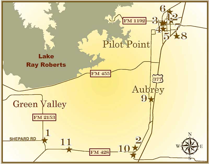
legend - Pilot
Point , Aubrey, Green Valley & Area
1. Green Valley Schools
2. First Christian Church of Aubrey
3. City of Pilot Point
4. Pilot Point Post-Signal
5. Pilot Point Church of Christ
6. St. Thomas Aquinas Catholic Church
7. County Line Baptist Church
8. Skinner Cemetery
9. Belew Cemetery
10. Aubrey First United Methodist Church
11. Elm Fork Bridge |
|
| Type: |
THC Subject Marker, 2001
|
| Location: |
go 4 miles west of Aubrey on FM 428, then 0.25 miles north on FM 2153; school is
on the right of FM 438, Aubrey area. |
| Marker Text: |
Fertile farmland and plentiful timber attracted settlers to this part of Denton
County about 1870. The community that developed originally was called Toll Town
because of two roads that intersected at this point. Schoolteacher Henry Clay
Wilmoth suggested the name change to Green Valley. The post office opened in
1874, and there were several stores and a blacksmith shop in the community when
the first recorded subscription school for Green Valley children began in a
vacant farmhouse in 1878. Although the community lost a number of residents and
businesses when the Texas and Pacific Railroad bypassed it in 1881, the Green
Valley public school district was organized as District No. 20 in 1884. Local
carpenters Sam Gross and James Mays built a one-room schoolhouse, in which Lutie
Whayne was the first teacher. That building burned in 1894, and it was replaced
that year at a site about one-half mile north of the first schoolhouse. Green
Valley's third school, a new, four-room building, greeted students in 1919. In
1935 Green Valley School District offered only first through ninth grades, so
students traveled to Denton to complete their education. By the time Green
Valley School closed in 1949, with Florence Habern as the last teacher, it had
provided fine academic and athletic opportunities for several generations of
students in this rural area. The 1919 school building continues in use as a
community center. (2001) |
| Historical Narrative: |
Historical Narrative |
| Pictures: |
        |
|
|
| Type: |
THC Subject Marker, 2005
|
| Location: |
410 North Main Street, Aubrey. |
| Marker Text: |
Early Disciples of Christ in this area met as part of a Union Church in the
Spring Hill Community, where several denominations held services under a
brush arbor and in a local schoolhouse. In October 1894 the Disciples
established this Christian Church in Aubrey under the leadership of elders
R.C. Horn and E.B. Holmes. A frame sanctuary here served the church until a
tornado destroyed it in 1918. Members soon rebuilt and continued their
support of missions and benevolences in the process. An early commitment to
area Bible schools meant dramatic growth for the young church and set the
course for its history of worship service and outreach (2005) |
Historical Narrative: |
First Christian Church Of Aubrey |
| Pictures: |
     |
|
|
| Type: |
THC Subject Marker, 1978
|
| Location: |
Town Square, Main and Washington Streets, Pilot Point. |
| Marker Text: |
Attracted by fertile land and abundant water and game, pioneers began to settle
at this site near the edge of the Cross Timbers region in the late 1840s. The
village, first known as Pilot's Point, was named for a high point of timber that
served travelers as a landmark. Near an early immigrant trail, Pilot Point was
also a stop on the Butterfield State Route. A townsite was platted in 1854 on
land originally granted to Charles Smith. Dr. R. W. Edleman (1825-1904) of
Missouri came here to launch a medical practice and open a drugstore. James D.
Walcott ran the earliest general store and became the first postmaster in 1855.
Alphius Knight, a settler from New York, built and conducted the first school in
the town. Established by three local residents in 1872, Pilot Point Seminary was
later renamed Franklin College and operated here for almost 30 years. In 1878
the town's first newspaper was published and in 1884 a bank opened. A marketing
center for farmers and stock raisers, Pilot Point had a grist mill and a cotton
gin. The arrival of two railroads, the Texas and Pacific and the Missouri,
Kansas and Texas, boosted the local economy in the 1880s. Agriculture and light
industry form the base of the town's economy in the 1970s. (1978) Incise on
back: Marker sponsored by Chamber of Commerce Researched by: Mavis Burton, Norma
Cole, Clifton Irick, Judy Lewellen, Estelle Whitley |
| Historical Narrative: |
Historical Narrative |
| Pictures: |
     |
|
|
| Type: |
THC Subject Marker, 1984
|
| Location: |
111 E. Main Street, Pilot Point. |
| Marker Text: |
First published as the "Pilot Point Post," this newspaper was established in
1878 by David J. Moffitt (1848-1917) and James T. Jones (1845-1915). In its
early years, "The Post" supported the democratic party and local commerce and
opposed the lawless element in town. Between 1888 and 1898 "The Post" merged
with "The Mirror" and then with "The Signal" and has operated since then as the
"Pilot Point Post-Signal". As Denton County's oldest continuing newspaper, "The
Post-Signal" has played a significant role in bringing news to the community and
surrounding areas. (1984) |
| Historical Narrative: |
The Pilot Point Post Signal |
| Pictures: |
   |
|
|
| Type: |
THC Subject Marker, 1981
|
| Location: |
426 South Jefferson Street, corner of Jefferson and White Streets, Pilot Point. |
| Marker Text: |
This congregation organized about 1865, twenty years after members of the Peters
Colony began settling here. In 1874 the church deacons purchased land at this
site from George W. and Alice B. Merchant. A one-room frame chapel was
constructed here the following year under the supervision of A. W. Cooke.
Additions to the structure were completed later. Active in the support of many
programs, the church was also instrumental in the formation of a congregation in
the nearby community of Aubrey (7 miles south) in 1959. (1981) |
| Historical Narrative: |
Pilot Point Church of Christ |
| Pictures: |
    |
|
|
| Type: |
THC Subject Marker, 2007
|
| Location: |
925 N. Charcut Street, Pilot Point. |
| Marker Text: |
St. Thomas Aquinas Catholic Church has provided for the spiritual needs of
residents in this region since the late nineteenth century. Before that time,
Catholics in the town of Pilot Point, organized in 1854, had no nearby place of
worship. Early area Catholics, many of whom were of German origin, had to travel
two days to attend services in Gainesville or Sherman. By the 1890s, the firm of
Flusche Brothers and Sullivan recruited a number of German settlers to the town,
increasing the need for a Catholic Church. Sixty-three residents and visitors
gathered in 1891 for the first Mass given in the town. By 1892, parishioners
raised funds to build a structure, and the Diocese of Dallas consecrated St.
Thomas Aquinas Church on March 7, the feast day of St. Thomas. The following
year, the church opened a school and secured land for a cemetery. In 1904,
members built a larger sanctuary. The parish prospered until the economic
depression of the 1930s. In 1936, however, the church once again began to grow
under the leadership of Father Paul Charcut (1908-1968), who was actively
involved in both church and civic affairs in Pilot Point. In the following
years, St. Thomas Aquinas Church established significant programs to assist the
less fortunate in the area through charitable contributions. Congregation
members have also served as civic leaders, while others have entered into
religious vocations or participated in the U.S. military during wartime. Today,
the church continues in its historic role as a spiritual and community leader
for the surrounding area. (2007) |
Historical Narrative: |
St. Thomas Aquinas Catholic Church |
| Pictures: |
       |
|
back to top
|
| Type: |
THC Subject Marker, 2007
|
| Location: |
512 East Walcott Street, Pilot Point. |
| Marker Text: |
This church, originally called the Colored Missionary Baptist Church, has served
as a spiritual leader for African Americans in the area since 1863. Early
members met under a brush arbor before building a chapel near the Cooke and
Denton county line in 1874. In 1882, the church moved to Pilot Point. The County
Line congregation has been active in the community and state through a variety
of programs, including establishment of adult literacy classes, organized by
Pauline Wilkerson Varner in 1939, and serving as the host for associational
conventions. Today, County Line Baptist Church continues to serve a widespread
area of northeast Denton County. (2007) |
Historical Narrative: |
County Line Baptist Church |
| Pictures: |
    |
|
|
| Type: |
THC Subject Marker, 1998. Historic Texas
Cemetery Marker, 2012
|
| Location: |
From Denton take US 380 east to US 377, exit, go north on US 377 to Debbie Lane,
turn right. Cemetery is on left side of road, Pilot Point. |
| Marker Text: |
In the early days of Pilot Point, Lucinda (Glasscock) and Richard Skinner set
aside a 2.44-acre piece of land to be used as a cemetery. The first recorded
burial was that of 5-year-old Josiah Taylor in March of 1858; his father, Josiah
Sr., died the following July. Predominantly of Anglo-Saxon Protestant descent,
most of those buried here came from Kentucky, Virginia, Missouri, Arkansas, and
Tennessee. Many were farmers or ranchers. Significant graves include that of J.
D. Merchant, Sr., a local businessman who built the first brick building in the
area. Also here are several victims of yellow fever, including Prissie and Sarah
Wilson, sisters who died within 2 months of one another during the epidemic of
1872 and 1873. Two people named James Graham, born on the same date two years
apart, died on the same September day in 1867. Lucinda Skinner, the last charter
member of the Pilot Point First Baptist Church, died in 1890. By 1900, there
were probably 200 graves in the cemetery. The land was sold by John Skinner to
the Skinner Cemetery Association in 1905; the last recorded burial was that of
Joe Mylo Phipps, an infant who died in 1928. The Skinner Cemetery remains a
vital link to the early settlers of the Pilot Point community. (1998) |
Historical Narrative: |
The Old Skinner Cemetery |
| Pictures: |
 |
|
back to top
|
| Type: |
THC Historic Texas Cemetery Marker, 2012
|
| Location: |
3 miles north of Aubrey on US HWY 377; go west on Belew Road 0.1 mille; cemetery
is located at 9500 Belew Road, Pilot Point. |
| Marker Text: |
Around 1856, Richard (Dick) Aaron Belew (1820-1900) and Mary Jane Belew (1822-1902), their five children and 39 other families came together by wagon from Tennessee to Denton County. They stopped on a hill in an area later known as the Belew Schoolhouse Settlement, part of the A.G. Stapp Survey north of Aubrey. A school soon opened in a log cabin at the site and was later used as a church. The cemetery was located in close proximity to the school. The first piece of land was purchased in October 1880 from Richard Aaron Belew by the citizens of the Belew Schoolhouse Community to be used as a public grave yard. Over 70 red sandstone rocks mark many of the early graves in this original 2.8 acres. By the early 1900s, the Belew Cemetery was established as the main burial ground for the Aubrey area.
In 1902, a Ladies Cemetery Society was organized by Kate Hodges (1857-1906), Mary L. (Mollie) Henderson (1854-1919), Ola Price (1877-1955), Bettie Catlett (1855-1918), Mary Caddell (1854-1940) and Nora McIntosh (1872-1965) to raise funds for the care of the cemetery. To raise money for additional land, the Ladies Cemetery Society voted to hold a Thanksgiving dinner for the community. For 85 years, this fundraiser was a success and allowed the society, later renamed the Belew Cemetery Association, to purchase additional land in 1903 and for the construction of a house for the sexton in 1906 and a pavilion in 1910. Additional land was acquired in 1962 and 1983. The association’s first directors represented rural school districts in the surrounding area. Early settlers, association founders and veterans from the Civil War to the Gulf War are buried here. This historic cemetery continues to honor the area’s heritage and ancestors. Historic Texas Cemetery
- 2011 Marker is Property of the State of Texas |
Historical Narrative: |
Belew Cemetery Historical Narrative |
| Pictures: |
   |
|
back to top
|
| Type: |
THC Recorded Texas Historic Landmark, 2011
|
| Location: |
113 W. Plum Street, Aubrey. |
| Marker Text: |
In 1858, Dr. George T. Key and his family, originally from Missouri, moved to Denton County and settled near the present town of Aubrey. There they built log cabins, one of which was used for a school and church. The building, known as the Key School House was the home of one of the first Methodist Churches established in Denton County, later renamed Aubrey Methodist Church. For years, the congregation of the Aubrey Methodist Church met at the Key School and in members' homes under the guidance of Reverend F. V. Evans. In 1885, L. N. Edwards made an addition to the original town plat of Aubrey and offered a free lot to each church. The Aubrey Methodist Church accepted the lots on the corner of Plum and Maple Streets. Ed. F. Bates, a pioneer citizen of the county, donated funds to build a church building as church funds were extremely scarce.
Construction on a wood-frame building was completed in 1886. On April 14, 1918, a devastating tornado swept through Aubrey and destroyed the church. A new one-story brick veneer building was completed in February 1919. The exquisite pre-Raphael style stained glass windows depict stories of the Christian faith and allow vibrant colors to fill the sanctuary. In 1968, the church was renamed Aubrey first United Methodist Church when the Evangelical United Brethren Church and the Methodist Church combined. The church incorporated and built an adjacent fellowship hall in 1986. From meeting in a log cabin to enduring a cyclone, the Aubrey First United Methodist Church overcame many obstacles and continues to serve the community.
Recorded Texas Historic Landmark - 2011. Marker is Property of the State of Texas. |
| Historical Narrative: |
Aubrey First United Methodist Church Historical Narrative |
| Pictures: |
       |
|
back to top
|
| Type: |
THC Recorded Texas Historic Landmark, 2014
|
| Location: |
Between Denton and Aubrey, off FM 428 (Old Sherman Road) at Green Belt Park and Lake Ray Roberts. The bridge is 5.4 miles northeast of Loop 288 and FM 428 intersection or 4 miles west of Aubrey). Bridge still is in original location beside the newer bridge on FM 428. |
| Marker Text: |
This historic bridge was an important two-way traffic bridge over the Elm Fork of the Trinity River for growing automobile traffic in Denton County in the 1920s. The bridge is one of only two accessible iron and steel bridges in Denton County remaining in its original location on public land. Denton Construction Company began work on the bridge in 1922 and, at the time, it was the longest bridge in the county at 250 feet long. Concrete piers and abutments were installed in early March 1922 while crews waited for the shipments of steel to arrive later that month.
The main span of the bridge is a 100-foot Pratt through-truss; east and west approach spans are Warren pony trusses 70 feet in length. Early iron bridges could only accommodate one-way traffic. The Elm Fork Bridge was built for two-way traffic in response to the growing number of automobiles on the roads. Built on one of the original wagon trails leading out of Denton, the road became known as Sherman Highway, connecting Denton with the U.S. Federal Court in Sherman. It was used locally as a feeder road and mail route between Denton, Aubrey and Sanger. It also served early farms and cattle ranches in the area; some were later inundated when the river was dammed.
The bridge served traffic until 1990 when Sherman Highway (now FM 428) was widened and the bridge was bypassed. It was repurposed as a pedestrian bridge and remains in its original location as a part of the Ray Roberts Lake State Park Greenbelt. The Greenbelt opened on National Trails Day in 1999 as a wilderness recreation area with a 20-mile multiuse trail that follows the banks of the Elm Fork of the Trinity River. Recorded Texas Historic Landmark – 2014. Marker is property of the State of Texas. |
| Historical Narrative: |
Elm Fork Bridge Historical Narrative |
| Pictures: |
     
    |
|
Little Elm, Oak Grove, Oak Point & Area
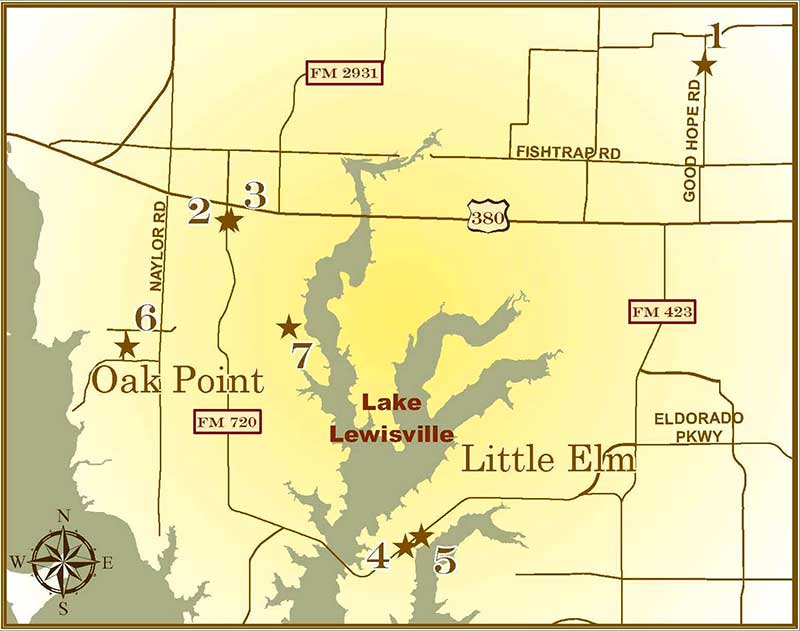
legend - Little
Elm, Oak Grove, Oak Point & Area
1. Good Hope Cemetery
2. Oak Grove
Methodist Church
3. William
Edmund Bates
4. Button
Memorial United Methodist Church
5. Community of
Little Elm
6. Taylor Family Cemetery |
|
| Type: |
THC Sesquicentennial Marker, 1986
|
| Location: |
15 miles east of Denton, north of US 380, east at intersection of Good Hope and
Prosper Roads between FM 1385 and Collin County line, Early Good Hope
Settlement. |
| Marker Text: |
Attracted to the area by its fertile soil, good water supply, and abundant
building materials, pioneers from Tennessee, Missouri, Georgia, Arkansas, and
Wisconsin settled here in the 1850s. Their colony, located on the Ben Rue
Survey, was first known as the Rue Settlement. Members of the Rue family were
probably the first to be buried on the acreage that now makes up this cemetery,
but the earliest legible grave marker, that of John Phillips, is dated 1870.
More than 80 burials took place in the 19th century, reflecting the hardship of
pioneer life. The name Good Hope was taken after the Good Hope Baptist Church
organized in 1875. The settlement also became known as Good Hope, although at
times it has been called Parvin as well. In 1903, a cemetery association was
formed to care for the graveyard. One year later Ben Rue (then a resident of
Fannin County) formally transferred the four acres he had set aside for
community purposes to the cemetery association. After area churches disbanded
and the school closed in 1949, the community population declined. The Good Hope
Cemetery thus stands as one of the few physical reminders of the early area
pioneers and of the community that once thrived here. Texas Sesquicentennial
1836-1986 |
Historical Narrative: |
Good Hope Cemetery |
| Pictures: |
     |
|
|
| Type: |
THC Subject Marker, 1973
|
| Location: |
on FM 720, just south of US 380, 10 miles east of Denton, Oak Grove Community. |
| Marker Text: |
Organized 1880, with worship services and Sunday school held under trees and a
brush arbor. Structure built 1881, by A.B. Harris. Six-acre site, including
nearby cemetery was donated by the Rev. William E. Bates (1812-83), retired
circuit rider and minister. Building costs were supplied through members' and
friends' donations, which included a horse. Men of the congregation hauled the
lumber from the sawmills in East Texas. This church was the first in the
community and has served five generations of residents. (1973) |
| Historical Narrative: |
Historical Narrative |
| Pictures: |
     |
|
|
| Type: |
THC Grave Marker, 1973
|
| Location: |
Oak Grove Cemetery on FM 720, just south of US 380, 10 miles east of Denton, Oak
Grove Community. |
| Marker Text: |
Born in Amherst County, VA.; licensed in Kentucky (1843) as a Methodist
minister. Came to Texas 1851; settled in Denton County. He was appointed (1853)
to 300-square-mile Dallas circuit, and traveled it once a month. Admitted 1854
to East Texas Conference, he founded churches at Montague, Pilot Point, Denton,
Jacksboro, Gainesville. He was very influential in planting Methodism in North
Texas. He married Susan Wright. They had ten children. Recorded - 1973 |
| Pictures: |
       |
|
|
| Type: |
THC Subject Marker, 2006
|
| Location: |
101 East Eldorado Parkway, FM 720, Little Elm. |
| Marker Text: |
The Rev. William E. Bates, a native of Virginia, established the Methodist
congregation at Little Elm in 1853. Members shared a meetinghouse with other
denominations at John House Springs and in 1916 built their own facility. In the
1950s, the church moved to make way for construction of Lewisville Lake. In
1962, a descendant of early Little Elm settlers and church members George and
Sarah Button donated funds for a new sanctuary; members renamed the church in
honor of the Button family. Throughout its history, the church has been active
in its community, offering a variety of services and programs to members and
area residents. (2006) |
| Historical Narrative: |
Button UMC Little Elm |
| Pictures: |
   |
|
|
| Type: |
THC Subject Marker, 1975
|
| Location: |
Beard Park, 300 East Eldorado Parkway, FM 720, Little Elm. |
| Marker Text: |
The Community of Little Elm is located on land that was part of the original Peters Colony Empresario Grant awarded by the Republic of Texas in 1841. Among the earliest colonists in this vicinity to receive land under the Peters Grant were John (d.1846) and Delilah (1806-1884) King, who moved from North Carolina in 1844 to settle a 640-acre tract about one mile southwest of this site. Their son, C.C.
"Kit" King (1823-1880), helped organize the first mail service in this area about 1845. When Little Elm Post Office was established in 1852, he was appointed postmaster. Another pioneer resident, William Dickson, was the first elected judge of Denton County, 1848-1852. Named for a nearby creek, the Community of Little Elm was formed by the consolidation of several small settlements, including Lloyd, Hackberry, Dickson, and Hilltown. As it grew, the town acquired a school, churches, a cotton gin, grocery and drug stores. Further growth accompanied the development of recreational facilities following the creation of Lake Dallas in 1925-26 and Garza-Little Elm Reservoir (now known as Lake Lewisville) in the mid-1950s. Construction of the reservoir prompted relocation of many historic structures, roads, and cemeteries that were threatened by rising water. However, the community's proximity to Lake Lewisville and to Dallas-Fort Worth International Airport, along with population migration from nearby large cities, caused Little Elm to grow instead of falter, and the town was officially incorporated in 1966. (1976, 2010) (Marker was stolen and replaced in 2010 by Town of Little Elm) Marker is Property of State of Texas |
| Historical Narrative: |
Historical Narrative |
| Pictures: |
        
 |
|
|
| Type: |
THC Historic Texas Cemetery Marker, 2001
|
| Location: |
from Denton, take US 380 east to Naylor Road, go south 2.1 miles to Emerald
Sound, turn right on Emerald Sound, go .5 miles to Alexandrite Drive, turn right
on Alexandrite Drive go .3 mile. Cemetery is located next to Alexandrite Park,
Oak Point. |
| Marker Text: |
Taylor Family Cemetery
SSamuel L. (1806-1877) and Martha (1811-1875) Taylor, their sons Moses
(1846-1875), Richard (1842-1922) and Benjamin (1836-1908), with his family, were
among the earliest settlers in this area known as Sand Town. They arrived here
from North Carolina in 1859 with slaves Kijeah, Matilda and James, and
accompanied by friends William (1803-1883) and Beulah (1810-1870) Lunn and son,
E.S. (1848-1874). The Taylors prospered as farmers and livestock breeders; the
tale is still told of the "race mare" sold by Moses to outlaw Sam Bass. Not all
graves are marked, but the remaining stones chronicle the lives of these
pioneers of the Little Elm area.
Historic Texas Cemetery - 2001/td>
|
| Historical Narrative: |
Taylor Family Cemetery
|
| Pictures: |
     |
|
back to top
|
| Type: |
THC Historic Texas Cemetery 2011 (Marker funded by Texas Historical Commission through 2013 Undertold Story Program. THC uses date of 2011 HTC designation for record purposes.)
|
| Location: |
Lloyd Road in Little Elm area. Directions from Denton: Take US Highway 380 east to FM 720; go south on Lloyd Road (gravel road) about 1.4 miles from US 380; turn east on Lloyd Road and follow approximately 1.2 miles; road will curve to south; cemeteries are on right side of road. The cemeteries are located in the community once known as Lloyd near the Oak Grove Community. FM 720 connects to the town of Little Elm. |
| Narrative: |
Harrington, Cassady and Clark Cemeteries
|
| Marker Text: |
The Harrington, Cassady, and Clark Cemeteries are three separate historically African American Cemeteries all located on 1.77 acres in Denton County. The land was originally owned by the Harrington family and is the site of the Harrington Cemetery. Cassdy and Clark Cemeteries were moved to their current location adjoining Harrington Cemetery in 1953 when the U. S. Army CORPS of Engineers began construction of the Garza Little Elm Dam. The reinterred cemeteries have twelve foot boundaries around the perimeters. An entrance gate is located on Lloyd Road at the northeast corner of the cemeteries. Lloyd, an early farming community, dates back to 1850 and was named for A. P. Lloyd, Denton County’s first county clerk. Most graves in Harrington are marked with headstones of marble, granite, sandstone and concrete. Fieldstone and funeral home steel-plates mark many Cassady and Clark graves. The three burial grounds have approximately 170 graves.
The only African American owner of the Harrington land was E. L. Lugrand. His brother’s father-in-law, Nick Oldem, was the first documented burial in Harrington Cemetery (1872). The sites of the original Cassady and Clark Cemeteries were on land owned by African Americans. Jacob Cassaby (1808-1908) purchased the Cassady Cemetery land near Garza in 1872. He and his wife, Melinda ((1821-1904), are buried in this family cemetery. Zack Rawlings and George Clark purchased the cemetery land west of Garza in 1876. The oldest legible marker is Nancie Rolling (1879). Present-day Lewisville Lake covers the area where these cemeteries were first established . Meggs & Son Funeral Home deeded Cassady and Clark Cemeteries to Denton County after relocating the burials. Historic Texas Cemetery – 2011, Marker is Property of the State of Texas
|
| Pictures: |
      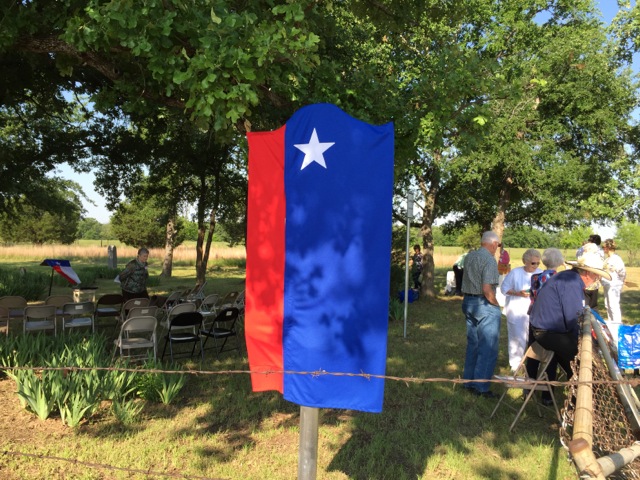 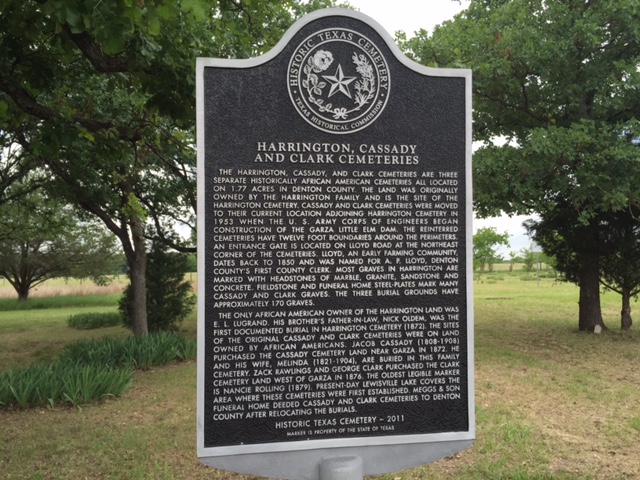 |
|
Old Alton, Copper
Canyon & Area
legend - Old Alton, Copper Canyon & Area
1. Rector Road Bridge at Guyer High School
2. Annie Webb Blanton of Denton County
3. Old Alton Bridge
4. Chinn's Chapel Cemetery
5. Chinn's Chapel Methodist Church
6. Old Alton Cemetery
7. Old Alton Memorial to Denton County Pioneers Who Founded Alton
8. Bartonville |
|
| Type: |
DCHC Marker, 2004; Listed in National Register
of Historic Places, 2004
|
| Location: |
7501 Teasley Lane, on the campus of Guyer High School, Denton. |
| Marker Text:
| This iron bridge, named to the National Register of Historic Places in January
2004, was built in 1907-08 by the Austin Bros. Bridge Co. of Dallas. It was
located 2.5 miles SE of Sanger on Rector Road at Clear Creek. Citizens of the
Sanger area donated $1,200 on the cost of $1,664. The Pratt through-truss bridge
span is 80 feet. It was relocated to this site in April 2005. |
| Historical Narrative:
| Rector Road Bridge |
| Pictures: |
    |
|
back to top
|
| Type: |
THC Subject Marker 2011
|
| Location: |
Annie Webb Blanton Elementary School, 9501 Stacee Lane, Argyle. |
| Marker Text:
| Annie Webb Blanton, born Aug. 19, 1870 in Houston to Thomas Lindsey and Eugenia Webb Blanton, began her teaching career at Pine Springs School (Fayette Co.) at age 17. She then taught for a few years in Austin, where she graduated from the University of Texas. In 1901, Blanton began her 17-year teaching career as an associate professor at North Texas State Normal College (now University of North Texas) where she promoted gender unity, published grammar exercise books which were used across the country, and assisted in numerous school activities.
Blanton is remembered for becoming the first woman president of the Texas State Teachers Association in 1916 and the first woman elected to a state office as the State Superintendent of Public Instruction in 1918. In 1921, Denton County honored Blanton for contributions in education when it named the county's consolidated Hawk and Chinn's Chapel schools the Annie Blanton School District. In 1922, after serving a second term as State Superintendent, she ran as a democratic candidate for Representative of the Thirteenth Congressional District but came in third. She earned a master's degree in 1923, followed by a doctorate in 1927, and was made an associate professor of school administration and chair of the Rural Education Department at the University of Texas. In 1933, Blanton was promoted to a full professor. In addition, she is noted for being a member of numerous professional organizations and for helping found the Delta Kappa Gamma Society in 1929. Blanton died Oct. 2, 1945 and continues to be recognized for her leadership, commitment to education and numerous achievements in offices that had never before been held by women.
175 Years of Texas Independence * 1836-2011 Marker is Property of the State of Texas |
Historical Narrative: |
Annie Webb Blanton Historical Narrative |
| Pictures: |
   |
|
|
| Type: |
Listed in National Register of Historic Places,
1988, THC Recorded Texas Historic Landmark, 2010
|
| Location: |
from I-35E. in Denton, exit at Teasley Lane (FM 2181) going south approx. 5.2
miles, eventually passing Guyer High School and Old Alton Cemetery, turn right
at traffic light onto Old Alton Road and take 2nd left prior to new bridge into
parking lot of Old Alton Bridge and Park, Denton. |
| Marker Text: |
Completed in 1884 to span the Trinity River tributary of Hickory Creek, this
bridge was built as an important link between the two economic centers of
Dallas and Denton. The bridge was one of eight authorized for construction
by the Denton County Commissioners Court in 1882. The span was constructed
near the small town of Alton, which had served as the county seat from 1851
until 1857, with the hopes that the bridge would bring life to the declining
community. However, Alton never regained its viability and the community
gradually disappeared. Records show that the bridge was constructed from a
kit provided by the King Iron Bridge and Manufacturing Company of Cleveland,
Ohio, which was a major supplier of bridges throughout Texas and North
America. The bridge is approximately 145 feet in length and consists of a
main span and two secondary spans. The main span is an iron, six panel Pratt
through truss and is 108 feet long. A latticed guardrail runs the length of
the main span, and the bridge's deck is fourteen feet in width. The
structure saw heavy horse-drawn and then vehicular traffic for more than 100
years, until construction of a new concrete bridge adjacent to the iron
bridge was completed in 2001 and the Old Alton Bridge was closed. Denton
County citizens encouraged the retention of the bridge and the structure has
been restored and incorporated into a series of parks and horse and hiking
trails, ensuring that it will continue to be used, while serving as a
reminder of Denton County's transportation history.
Recorded Texas Historic Landmark 2010,
Marker is property of the State of Texas |
| Historical Narrative: |
Old Alton Bridge |
| Pictures: |
        |
|
|
| Type: |
THC Subject Marker, 1996; Historic Texas
Cemetery Marker, 2001
|
| Location: |
1-35 E, exit FM 407/Justin Road, go west about 3 miles on FM 407/Justin Road
then about one mile north on Chinn Chapel Road, Copper Canyon. |
| Marker Text: |
Elisha and Mary Stowe Chinn purchased this site in 1853 and donated 10 acres
atop the hill north of Lockhart Spring. As deaths occurred among the early
settlers to this area, services were held in the log cabin chapel, and graves
were placed nearby. Travel to the cemetery was difficult, especially for those
living outside the community. The wagon trail through the valley connected
Denton with Lewisville, but a westerly road leading to the nearby commercial
center at Waketon was needed. In 1885 a road connecting Chinn's Chapel community
to Waketon was built, incorporating the old wagon trail. It was named Chinn
Chapel Road. This cemetery features a variety of grave markers. Among the oldest
markers are those of limestone, while other early graves were marked simply with
rocks. Often a larger stone was placed at the head and a smaller one at the foot
of the grave. Some family plots display mounds of earth outlined with shells, a
folk tradition brought to America by African slaves. Many tombstones are carved
from native sandstone, while later monuments display ornate decorations, such as
columns, urns, pediments and round-topped finials. This cemetery continues to
serve the community. (1996) |
Historical Narrative: |
Chinn's Chapel Cemetary |
| Pictures: |
    |
|
|
| Type: |
THC Subject Marker, 1996
|
| Location: |
1-35 E, exit FM 407/Justin Road, go west about 3 miles on FM 407/Justin Road, go
north about one mile on Chinn Chapel Road, Copper Canyon. |
| Marker Text: |
This church began as a nondenominational congregation organized by pioneer
settlers of the Peters Colony in 1846. Itinerant preachers were invited to hold
services in a log church/school building located about one quarter mile
northwest of here. The log chapel was on 10 acres called Antioch donated by
North Carolina immigrants Mary Stowe Chinn (1808-1871) and Elisha Chinn
(1802-1876) for church and cemetery purposes. The church was admitted to the
North Texas Conference of the Methodist Episcopal Church, South, in 1872, as
Chinn's Chapel Methodist Church. Sunday School classes began that year. In 1877
the church purchased 4 acres here at the site of freshwater springs and early
camp meetings. A sanctuary was erected and a tabernacle built for summer
revivals. The property also included a combination Woodmen of the World Lodge
Hall/public school from 1884 to 1921. Chinn's Chapel served as the main
gathering place for the area. Though membership declined sharply after World War
II, the church endured. Through denominational merger it became Chinn's Chapel
United Methodist Church in 1968. Local efforts to revive the institution began
in the late 1980s, and an active membership was reestablished. The building was
renovated in 1996. (1996) |
Historical Narrative: |
Chinn's Chapel United Methodist Church |
| Pictures: |
   |
|
back to top
|
| Type: |
THC Subject Marker, 2002; Historic Texas
Cemetery Marker, 2002
|
| Location: |
5720 Teasley Lane, Denton. |
| Marker Text:
| With burials dating to 1852, this graveyard is associated with some of the
earliest settlement in Denton County. In that year, Rebecca Daugherty, daughter
of one of the pioneer families, died and was buried on family property. Over
time, burials of neighbors and relatives continued on the site, and in 1909 the
land was donated and dedicated as a private cemetery. Alton was the county seat
of Denton County from 1851 until 1856. Located on Hickory Creek, the community
flourished with stores, a hotel, post office, school and other businesses.
Nearby is the Hickory Creek Baptist Church, organized in the Alton community in
1855. When the county seat was moved to Denton in 1856, Alton began to decline,
but many families continued to bury their dead in this cemetery. The graveyard
contains more than 600 burials, including 20 graves that are unmarked and 55
burials that are marked only with rocks or sandstone. Pioneers, veterans and
others with ties to the old Alton community rest here. The Old Alton Memorial
Cemetery Association cares for the graves and gathers annually in the spring for
Decoration Day. As the area becomes more urban, the Old Alton Cemetery stands as
a reminder of the region's rural past. (2002) |
| Historical Narrative:
| Old Alton Cemetery |
| Pictures: |
      |
|
|
| Type: |
Daughters of the American Revolution (Granite Marker) 1930
|
| Location: |
Relocated to Old Alton Cemetery at 5720 Teasley Lane, Denton.
Marker was originally located on 30’ x 30’ plot donated by Misses Ida and
Violet Stuart in 1930. According to C. A. Bridges, “It was near Thompson’s barn on the
east side of the road about one hundred yards from the bridge that crosses Hickory Creek
and perhaps a quarter mile from Alton Baptist Church on the west side of the road.”
The marker was a project of the Benjamin Lyons Chapter of Daughters of the American Revolution
and it is believed it was moved in 2001 to Old Alton Cemetery when the Old Alton Bridge
was closed to traffic and new bridge and road were built adjacent to the historic bridge.
This site, where the marker was originally placed, would have been the third
Denton County Seat at the second Alton site. |
| Marker Text:
| Dedicated to the memory of the Denton County pioneers who founded Alton
by the Benjamin Lyons Chapter of Daughters of the American Revolution. 1930 |
| Pictures: |
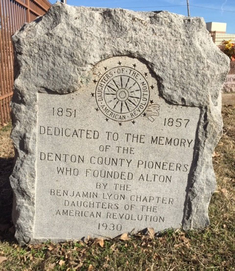 |
|
| Type: |
THC Subject, 2016
|
| Location: |
1941 E. Jeter Road, Bartonville Town Hall, Bartonville |
| Marker Text:
| Dedicated to the memory of the Denton County pioneers who founded Alton
by the Benjamin Lyons Chapter of Daughters of the American Revolution. 1930 |
| Narrative:
| The Town of Bartonville and Its Landmark Store |
| Pictures: |
    |
Lake Dallas, Corinth, Shady Shores & Area
legend - Lake
Dallas, Corinth, Shady Shores & Area
1. Corinth Shiloh Cemetery
2. Swisher Cemetery
3. 1848 Denton County Seat |
|
| Type: |
THC Historic Texas Cemetery Marker, 2003
|
| Location: |
6 miles south of Denton, I mile east of IH-35 at intersection of Shady Shores
Road and Swisher Road, Corinth. |
| Marker Text: |
Physician and lay preacher Thomas A. Ball and his wife, Nancy (Yeats), came to
Denton County from Missouri soon after the Civil War ended in 1865. They settled
with their family on land that would become the community of Corinth. The Ball
family donated land already in use as a graveyard to the Primitive Baptist
Church at Shiloh. The first marked grave is that of William Garrison (d. 1870).
In 1880, the Wichita & Dallas Railway named the settlement Corinth. An
additional land donation in 1953 enlarged the cemetery to 2.5 acres. The
community called the burial ground Shiloh Cemetery for many years until a
cemetery association formed in 1959 and members adopted the name Corinth Shiloh
Cemetery. Features of the early cemetery include native sandstone markers and
decorative mussel shells harvested from nearby creeks. Today, Corinth Shiloh
Cemetery chronicles the history of area settlers. Descendants and friends
reunite for annual decoration days to clean and decorate the graves of those
buried here.
Historic Texas Cemetery - 2003 |
| Historical Narrative: |
Historical Narrative |
| Pictures: |
     |
|
back to top
|
| Type: |
THC Subject Marker, 2001
|
| Location: |
603 N. Shady Shores Road, Lake Dallas. |
| Marker Text: |
Reflecting the earliest years of Anglo settlement in this part of north central
Texas, the Swisher Cemetery began on land granted to H. H. Swisher for his
service in the Texas War for Independence from Mexico. The oldest burial in the
cemetery, that of Francis Long, dates to 1867. When H. H. Swisher's son, Capt.
A. P. Swisher (1829-1920), inherited the property from his father, he formally
donated some of his land for use as a cemetery by the families of the community
then known as the French Settlement. Swisher's wife, Virginia, died in 1899 and
was the first member of the family buried in the Swisher plot. After the
railroad came through this area, the community's name was changed to Garza in
1881 and then to Lake Dallas in 1926 upon construction of the dam on the Elm
Fork of the Trinity that created the lake by the same name. Swisher Cemetery's
use over time has expanded to serve residents of many of the neighboring lake
communities. The burial ground contains the graves of numerous veterans who
served in the Civil War, World War I, World War II, Korea, Vietnam and the
Persian Gulf. Over the years, additional land was purchased for the cemetery,
which contains more than 1,100 graves. For many years, Garza community residents
took care of the cemetery. From 1948 until 1998, the Lake Dallas Birthday Club
maintained the graveyard. The Swisher Cemetery Association currently cares for
the historic burial ground. (2001) |
| Historical Narrative: |
History of Swisher Cemetery |
| Pictures: |
   |
|
back to top
|
| Type: |
THC Subject, 2016
|
| Location: |
1960 Post Oak Drive, Spirit Horse Therapeutic Riding Center, Corinth |
| Marker Text: |
1848 Denton County Seat |
| Pictures: |
N/A |
|
back to top
Lewisville &
Area
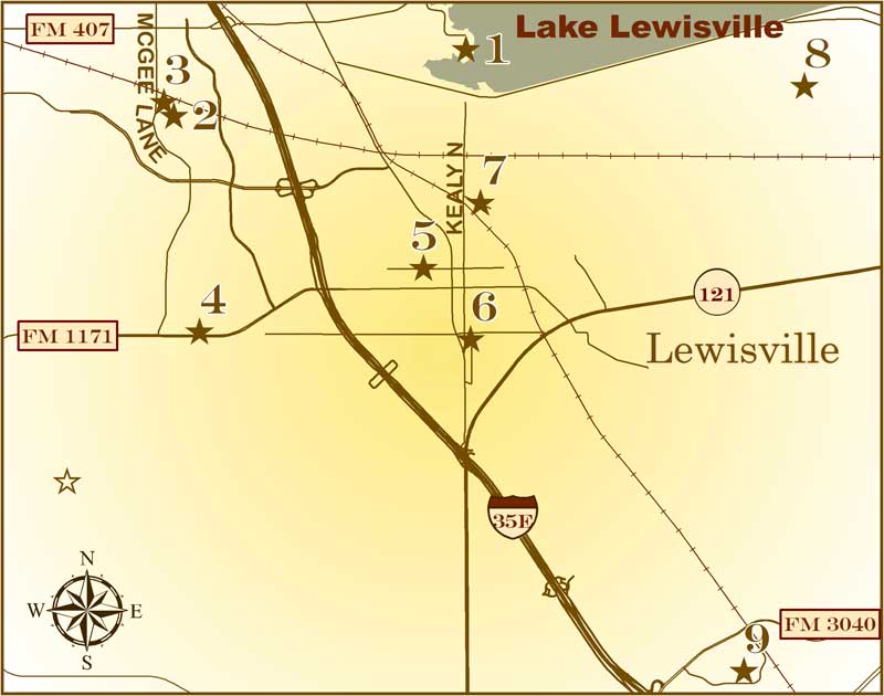
legend - Lewisville & Area
1. Lewisville Prehistoric Site
2. McCurley Cemetery
3. Old Hall Cemetery
4. The Peters Colony
5. Milliken House
6. Lane Chapel C.M.E. Church
7. Smith Cemetery
8. Ritter Cemetery
9. Texas International Pop Festival |
|
| Type: |
THC Subject Marker, 1980
|
| Location: |
on Sailboat Point off Trotline Road, near the dam, in Lewisville Lake Park, off
Lake Park Road, Lewisville. |
| Marker Text: |
During the construction of Lewisville Dam in 1950, a number of aboriginal
artifacts were unearthed; archeologists conducted several excavations (1952-57)
before the waters of Garza-Little Elm Reservoir covered the site. The
excavations revealed 21 hearths, vegetable matter, animal bone fragments and
lignite (coal) which was used for fuel. Scientific radiocarbon dating techniques
indicate the organic material is approximately 12,000 years old. The Lewisville
discoveries are similar in age and content to findings at the Clovis site in New
Mexico. (1980) |
Historical Narrative: |
Lewisville Prehistoric Site |
| Pictures: |
      |
|
|
| Type: |
THC Subject Marker, 1984
|
| Location: |
1400 block of McGee Lane at intersection with Colgate Drive, Lewisville. |
| Marker Text: |
The McCurley family of Illinois settled in Denton County in 1852. George Collins
McCurley set aside land for a burial ground, church, and school. A traveling
stranger may have been the first burial, but George's brother, Abraham, who died
in 1871, was the first family member buried at the site. The first marked graves
date from 1877, when the plot began to be used by neighbors. In 1951 the 106
graves which then comprised the cemetery had to be relocated because of the
construction of Lewisville Lake. They were moved here, adjoining Old Hall
Cemetery, burial place of George C. McCurley. (1984) |
Historical Narrative: |
McCurley Cemetery |
| Pictures: |
   |
|
|
| Type: |
THC Texas Sesquicentennial Marker, 1986
|
| Location: |
1400 block at McGee Lane at intersection with Quaker Lane, Lewisville. |
| Marker Text: |
In the 1840's the Republic of Texas government granted colonization contracts to
people who would advertise and bring new settlers to Texas. The Peters Colony,
led by W. S. Peters, was located in North Texas and included the area later
known as Denton County. In 1844 families began arriving in this area, including
those of John and James Holford of Missouri. The place where the Holford
families settled, on the prairie west of Big Spring Creek (Big Elm), became
known as Holford Prairie. By 1855 a two-story building was constructed for use
as a community meeting place. Referred to as Holford Prairie Hall, it housed a
Masonic Lodge on the second floor, and the first floor was used for school and
church purposes. This cemetery, situated next to the lodge building, became
known as Old Hall Cemetery. The earliest graves date to the 1850s and include
many infants and children. According to local oral tradition, the first burial
may have been that of a man who died as his family was traveling through the
area. The cemetery contains over one hundred twenty-five burials from the
nineteenth century. A cemetery association, organized in 1972, maintains the
historic graveyard. Texas Sesquicentennial 1836-1986 |
| Historical Narrative: |
Old Hall Cemetery |
| Pictures: |
  |
|
|
| Type: |
THC Subject Marker, 1970
|
| Location: |
1197 West Main Street (FM117I) in front of Municipal Annex, Lewisville. |
| Marker Text: |
(within area encompassed by) A reservation of land made under an Empresario
contract by the Republic of Texas, 1841. Its purpose was to introduce colonists
into this area. Under the first of four contracts, W. S. Peters and 19 partners
agreed to introduce 600 families in three years, to furnish each with seed,
shot, and a cabin, and also to survey the land. Each family was to receive 640
acres of land free and each single man, 320 acres. Of this, the company could
take half for its services. Three later contracts altered terms somewhat, and
although the land company underwent several internal upheavals, by 1848 there
were approximately 1,800 colonists and their families in the area. Resentment
over the company's share of land climaxed in 1852 when settlers drove out the
unpopular agent, Henry O. Hedgcoxe, in the so-called "Hedgcoxe War." Because of
its success in opening a large area of the frontier and its later effect on
Texas land and immigration policy, the law establishing this colony was one of
the most important in the Republic. In spite of unusual tumult and hardship, the
final Peters Colony area today extends over five counties and encompasses
one-fourth of the state's population, including its largest combined
metropolitan area. (1970) |
| Pictures: |
   |
|
|
| Type: |
THC Recorded Texas Historic Landmark, 1969
|
| Location: |
231 West Walters Street, Lewisville. |
| Marker Text: |
Built by William Dickerson Milliken, born in
Paducah, Ky., Nov. 1, 1848; married Margaret Crockett Young. Children: W. D.,
Jr.; Samuel Ramsey, M.D.; Thomas Gillespie; Martin Horace; Maggie Bell (Mrs.
Edens); Charles Young; Elizabeth Angelina; John Barnes. After going into
mercantile business in Lewisville in 1877, Milliken built this house, 1878.
Framing is native oak. Siding was freighted from Port City of Jefferson, in East
Texas.
Recorded Texas Historic Landmark, 1969 |
| Pictures: |
    |
|
|
| Type: |
THC Subject Marker, 2000
|
| Location: |
615 Hembry Street, Lewisville. |
| Marker Text: |
Anthony Hembry and six charter members, all former slaves, organized Lewisville
Colored Methodist Episcopal (C. M. E.) Church in 1882. Lewisville had the
largest African American population in Denton County and this church, called
Lane Chapel after 1902 for Bishop Isaac Lane, was a significant social center.
Other C. M. E. churches formed with the encouragement of this congregation. As
rural Americans migrated to larger cities in the 1920s-1940s, the black
population of Lewisville diminished and church membership dwindled. The church
survived the late 20th century through donations and funds from other C. M. E.
churches and the devotion of Lane Chapel members. A strong ministry in the 1990s
led to a revival for Lane Chapel, and by the beginning of the 21st century
membership had increased. (2000) |
Historical Narrative: |
Lane Chapel C.M.E. Church |
| Pictures: |
  |
|
|
| Type: |
THC Subject Marker, 2001
|
| Location: |
328 Smith Road, Lewisville |
| Marker Text: |
This area of Denton County was known as Holford's Prairie in the mid-19th
century, named for brothers John and James Halford (Holford), pioneer settlers
who obtained 640 acres of land as members of the Peters Colony. Basdeal W. Lewis
platted the town of Lewisville in 1853. Thomas Morgan (1814-1887) and Elizabeth
A. (1815-1883) Smith purchased 318 acres of land here in 1859. They sold two and
one-half acres of their farmland to the Lewisville Masonic Lodge in 1881 for the
establishment of a community cemetery. The site had been used as a burial ground
since 1862, when the Smiths' 20-year-old son, James J. Smith, died and was
buried on the family farm. His is the earliest marked grave in the Smith
Cemetery. Among the pioneer Denton County family names that can be seen on
gravestones here are Herod, Sherrill, Clayton, Skillern, Cobb, Jenkins, Temple,
Bourland, Hamilton, Fenlaw, Oliver and Fox. John Moore (1834-1922) and Ann Eliza
(1849-1923) Fox had the sad task of burying six children here between 1863 and
1882, a testament to the often harsh conditions of pioneer life. Local oral
history records suggest that some of the unmarked graves in the Smith Cemetery
are those of former slaves of the Julius Kane Fox family. The Smith Cemetery
Association, organized in 1950 to maintain the historic graveyard, purchased the
site from the Masonic lodge in 1972. Currently containing more than 400 marked
graves and an unknown number of unmarked ones, the cemetery remains in use by
the community and by descendants of the pioneer families interred here. (2001) |
| Historical Narrative: |
Smith Cemetery |
| Pictures: |
  |
|
|
| Type: |
THC Historic Texas Cemetery, 2001
|
| Location: |
Enter Lewisville Lake Environmental Learning Area at corner of Jones and Kealy
Streets. Get a pass and go through gate at dam outlet. Follow road until
pavement runs out. Turn right on Fish Hatchery Road and right again to the
cemetery, Lewisville. |
| Marker Text: |
Ritter Cemetery
Established ca. 1860
Historic Texas Cemetery - 2001 |
| Historical Narrative: |
Ritter Cemetery |
| Pictures: |
   |
|
|
| Type: |
THC Subject Marker, 2010
|
| Location: |
900 block of Lakeside Circle, Denton County Transportation Authority's Hebron
Station, Lewisville. |
| Marker Text: |
The Texas International Pop Festival took place near this site during Labor
Day weekend, 1969. It was held two weeks after the Woodstock Music and Art
Fair introduced much of Mainstream America to the "Hippie" culture by way of
news reports of the chaos that occurred there in part due to rainy weather
and lax security. The Texas festival brought as many as 150,000 hippies,
bikers and music lovers to Lewisville, which at the time had a population of
approximately 9,000 citizens. The Dallas International Motor Speedway,
situated along Interstate Highway 35 south of town was chosen as the
location for the event. Twenty-five musical acts representing the genres of
soul, blues and rock and roll performed during the three days of the
festival. Acts included Janis Joplin, Sly & The Family Stone, Grand Funk
Railroad, Chicago Transit Authority, Herbie Mann and a relatively unknown
United Kingdom Band called Led Zepplin. On the north side of Lewisville, a
public campground situated on the shores of Lewisville Lake served the
thousands of festival attendees. A small "Free Stage" was constructed at the
campground and local bands were brought in to perform for the campers. The
skinny-dipping in Lake Lewisville that resulted from the lack of shower
facilities and the late summer heat drew much attention. Many locals
demanded that the festival be shut down because of the threat of violence
and unsavory activity, but there were no acts of violence reported at the
festival. However, area citizens were introduced to a culture that had
previously been foreign to them and many who attended look back on the
festival as a life-changing event. (2010), Marker is Property of the State
of Texas. |
Historical Narrative: |
Texas International Pop Festival Historical Narrative |
| Pictures: |
      |
|
Carrollton,
Hebron, The Colony & Area
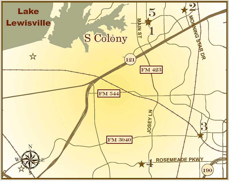
legend - Carrollton, Hebron, The Colony & Area
1. Hedgcoxe War
2. Bridges Cemetery
3. First Baptist Church of Hebron
4. Furneaux Cemetery
5. Belz Road Bridge at Duck Creek |
|
| Type: |
THC Subject Marker, 1975
|
| Location: |
southeast corner of Blair Oaks and South Colony Drive, The Colony. |
| Marker Text: |
Distribution of land in the Peters Colony of North Texas triggered a dispute
known as the Hedgcoxe War. The Texas Emigration and Land Co. organized the
colony under an 1841 Republic of Texas law which allowed it to keep one-half of
a settler's grant. After protests, this right was repealed, but in Feb. 1852 the
company was compensated with 1,088,000 acres of vacant land within the colony.
This action angered settlers and speculators with land certificates, who feared
that the large grant would lower land values. At that time, the company's
unpopular agent, English-born Henry O. Hedgcoxe, operated a land office on
nearby Office Creek. On July 12 and 13, 1852, a group of Dallas men broke in and
examined the land records. They reported to a meeting in Dallas on July 15 that
the company was defrauding the colonists. John J. Good (1827-82), later mayor of
Dallas, then led a band of armed men to Hedgcoxe's office. Hedgcoxe escaped, but
most of his files were seized and the office burned. After the raid, tensions
quickly cooled. The law was amended so that settlers obtained their grants from
the state rather than from the company agent. The company kept its land grant,
however, and Hedgcoxe returned to help survey the tract. (1975) |
Historical Narrative: |
The Hedgecoxe War |
| Pictures: |
  |
|
|
| Type: |
THC Sesquicentennial Marker, 1986
|
| Location: |
drive north on HWY 121 Business from IH-35. Turn north (left) on Paige/Plano
Parkway (in the Colony), then right on Memorial Drive and left on Morning Star;
cemetery is on left side of road on the corner of Morning Star and Chesapeake
Drive, The Colony. |
| Marker Text: |
Bridges settlement, named for the W. A. Bridges family and reportedly the oldest
in Denton county, began in 1843 and was a center of activity of the Peters
Colony. This cemetery, on land granted to Bridges in 1850, dates to 1855,
although illegible stones may be slightly older. Site of the burials of the
Bridges and other early immigrant families, stones here document graves of many
children and Civil War soldiers. Deeded to the county by F. M. and Sallie
Bridges in 1889, the cemetery contains over one hundred sandstone and granite
markers. Texas Sesquicentennial 1836-1986 |
Historical Narrative: |
Bridges Cemetary |
| Pictures: |
     |
|
|
| Type: |
THC Subject Marker, 1984
|
| Location: |
corner of FM 544 and Hebron Parkway in Hebron, 10 miles east of Lewisville. |
| Marker Text: |
Organized in 1883 at the Willow Springs School, this congregation was known as
Big Valley Baptist Church during the early years of its existence. A Sunday
School, Willow Springs Union Sabbath School, was begun in 1886. E. C. Bramblett
served as the first pastor. He was replaced by the Rev. John Turner, who was
succeeded after one year by the Rev. R. G. M. Eiland. During Eiland's pastorate,
toward the latter part of the nineteenth century, the congregation and Sunday
School united with a nearby fellowship to become the Cemetery Hill Church and
Union Sabbath School. In the early 1900s, during the pastorate of the Rev. D. B.
Allen, the congregation relocated to the new town of Hebron and adopted the name
Hebron Baptist Church. Their first sanctuary was completed in 1920. Over the
years the fellowship has been active in missionary work and has produced several
ministers from its membership. Now known as First Baptist Church, Hebron, the
historic congregation has contributed much to the heritage of the area and has
provided significant service and leadership to the residents of this part of
Denton County. (1984) |
Historical Narrative: |
First Baptist Church of Hebron |
| Pictures: |
   |
|
|
| Type: |
THC Subject Marker, 1984
|
| Location: |
on Cemetery Hill Road, 1/2 block south from its intersection with Rosemead
Parkway, Carrollton. |
| Marker Text: |
William Furneaux, a native of England, came to Texas in 1857 and married Fanny
Jackson (d. 1917), whose family had come to Texas in 1848 as part of the Peters
Colony. This cemetery was established in 1884, when Furneaux died and was buried
on a section of his farm he had indicated should become a public graveyard.
Seven-year-old Peter Husky died soon after and was buried near Furneaux.
Although three graves bear earlier dates, they were moved here from other
cemeteries. With establishment of the cemetery, Peter Husky's father, William,
donated part of his land for use as a church site. A public meeting was then
held to discuss plans for laying out plots and building a sanctuary. A cemetery
association was chartered in 1888, and the graveyard officially became known as
Furneaux Cemetery. Charter directors chosen were Joseph Morgan, W. R. Dudley,
John Jackson, V. S. Dudley, and J. H. Furneaux. Originally surrounded by
extensive farmland, the church and cemetery sites became known as Cemetery Hill.
When a 1924 tornado destroyed the frame church building, the cemetery
association acquired the land. The Furneaux Cemetery is the burial place for
many area pioneers and their descendants. (1984) |
Historical Narrative: |
Furneaux Cemetery |
| Pictures: |
   |
|
|
| Type: |
DCHC Marker, 2015
|
| Location: |
Relocated to City Park in The Colony (NE corner of Blair Oaks Dr and S Colony Blvd) |
| Marker Text: |
Belz Road Bridge is a four-panel Warren pony truss steel bridge erected in the early 1900s. It crossed Duck Creek in northwestern Denton County on land purchased by Josh B. Nance in 1898. Belz Road was named for the Alfred and Bertha Belz family who moved to the area in 1910. The bridge was used by horse-drawn wooden farm wagons that transported wheat and small grain crops to flour mills and the Gulf, Colorado and Santa Fe Railway in Sanger. Possibly manufactured by King Iron and Bridge Co., Cleveland, Ohio, it is 87 ft long, 11.8 ft wide and 7.5 ft high. Denton County closed the bridge in 2007. It was relocated to The Colony’s Greenway Park in 2008. Denton County Historical Commission - 2015 |
Historical Narrative: |
Belz Road Bridge at Duck Creek Historical Narrative |
| Pictures: |
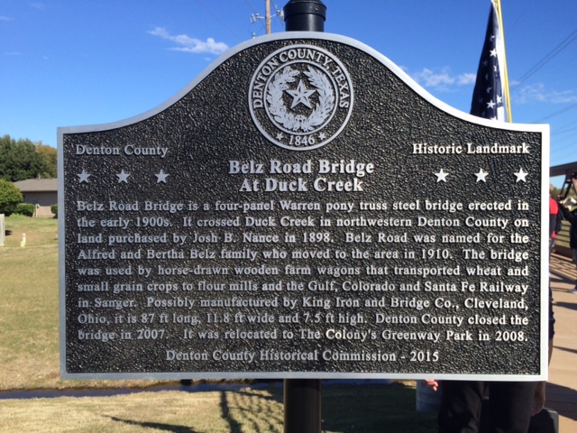 |
|
Flower Mound &
Area
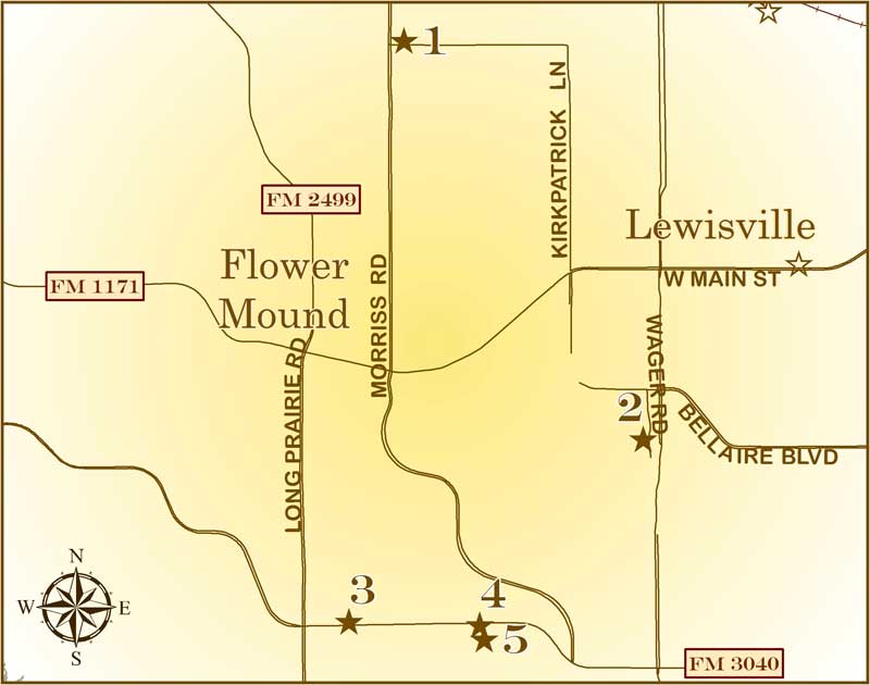
legend - Flower
Mound & Area
1. Bethel Community
2. McCombs
Cemetery
3. Flower Mound
4. Flower Mound
Presbyterian Church
5. Flower Mound Cemetery |
|
| Type: |
THC Subject Marker, 1990
|
| Location: |
2100 Kirkpatrick Lane just east of its intersection with Morris Road in Flower
Mound in front of Bethel Chapel, Flower Mound. |
| Marker Text: |
Settlement of this area began in the 1850s. Among the pioneer families were
those of Samuel K. Smith, Anderson Nowlin, William Crawford, and Sam Lusk. As
family farms were established, a loosely organized rural community was formed.
By the 1870s more people had moved to the area, including the F. M. Frie family.
The Frie and Nowlin families both set aside land for school and church purposes.
A one-room schoolhouse built on the Nowlin land about 1871 became known as Frie
School. It also served as a Union church and community center. A church building
was erected on Frie land in 1882. After Bethel Presbyterian Church was organized
in 1883, the school and community took the Bethel name At its height in the
early 20th century, Bethel community included about one hundred families. After
it was bypassed by the railroad in 1875, Bethel began to decline in favor of
Lewisville. The Bethel School consolidated with the Lewisville School system in
1940, and the area once encompassed by farms of the Bethel Community eventually
became parts of several towns, including Flower Mound, Lewisville, Highland
Village, and Copper Canyon. (1990) |
Historical Narrative: |
THE BETHEL COMMUNITY SCHOOL AND CHURCH |
| Pictures: |
    |
|
|
| Type: |
THC Subject Marker, 1997
|
| Location: |
on Wager Road, south of intersection of Wager Road and St. Gallen Lane, Flower
Mound. |
| Marker Text: |
The history of this small community cemetery dates to the 1850s, before Denton
was selected as county seat. The site contains graves of early pioneers of the
Lewisville-Flower Mound area. Settlers included Nehemiah Wade Boyd (1823-1856),
his wife Susan McCombs Boyd (1824-1917), their six children, family matriarch
Mary Nowlin McCombs (1803-1867), and members of Nowlin, Sigler and Rivers
families who arrived in 1855 from Tennessee. Nehemiah Boyd died suddenly of
pneumonia after being chilled by a blue norther while building a log cabin for
his family, and was buried on land donated by his brother-in-law, John Mathis
McCombs. Susan Boyd later gave birth to their seventh child and first Texan,
George Taylor Boyd (1856-1933). Although Nehemiah Boyd's burial was long
believed to be the first, archeological evidence suggests as many as 100
individuals may have been buried here and that the site was a community cemetery
in use between the 1850s and 1890s. Typically graves were marked with native
sandstone or brick. Boyd descendants formed the McCombs Cemetery Association in
1990 to protect the burial site from encroaching development. (1997) |
Historical Narrative: |
McCombs Cemetery |
| Pictures: |
  |
|
|
| Type: |
THC Subject Marker, 1984
|
| Location: |
on Flower Mound Road (FM 3040) just east of intersection with Long Prairie Road
(FM 2499) attached to stone wall, Flower Mound. |
| Marker Text: |
Settlers of the Peters Colony named this smooth, dome-shaped hill for the
abundant wild flowers that grow on it. Rising fifty feet above the surrounding
prairie, Flower Mound, long has been a point of interest in the area. According
to local legends, no structure was ever constructed on top of the mound, nor has
any tree grown here. Before W. S. Peters began bringing settlers to the land
issued him by the Republic of Texas Congress, Wichita Indians inhabited the
area. During the 1840s, Peters colonists began moving to the prairie in search
of good farmland. In 1844, John R. Wizwell was granted 640 acres of land that
included the mound. His widow, Edy, later remarried and sold this land to George
L. Beavers. Flower Mound remained in the Beavers family well into the twentieth
century. Although the hill has remained in private ownership, it historically
has been identified with the community that grew up around it. Flower Mound
Presbyterian Church was the first to officially use the name in 1854. Once a
sprawling agricultural community, Flower Mound has begun to expand with the
urban growth of nearby Dallas and Fort Worth, leaving this formation as a
historic reminder of its pioneer days. (1984) |
Historical Narrative: |
Flower Mound |
| Pictures: |
      |
|
|
| Type: |
THC Subject Marker, 1967
|
| Location: |
1501 Flower Mound Road, (FM 3040), next to Flower Mound Cemetery, Flower Mound. |
| Marker Text: |
First Presbyterian Church in county. Organized 1854 by the Rev. Matthew B.
Donald, who is buried in church cemetery. Worship was in homes before a log
church was built, 1857-58. A frame building erected later; present one built
1901. (1967) |
Historical Narrative: |
Flower Mound Presbyterian Church |
| Pictures: |
      |
|
back to top
|
| Type: |
THC Historic Texas Cemetery, 2003
|
| Location: |
1501 Flower Mound Road (FM 3040), Flower Mound. |
| Marker Text: |
Matthew and Isabella Doyle (Douglass) Donald arrived in Denton County, Texas in
1854. That year, Matthew, a successful farmer, set aside 10 acres for a
cemetery, campground and the Flower Mound Presbyterian Church. He served as the
first Pastor of the church, to which he formally deeded the land in 1879. The
cemetery was used soon after it was established. The first burial was reportedly
that of a girl who died at a church camp meeting. The earliest marked burial is
that of Ola Hall (d. 1873). The earliest birth date on a2 marker is that of
Anderson Spinks (b. 1808). Early Flower Mound families initially had plots. The
Donald plot includes burials of the cemetery's founder and his brother, Robert
Henderson Donald, who served as church deacon and state legislator. Other
families include the Simmons, Bakers and Crawfords. In 1950, the Dyer Family
Cemetery was relocated to Flower Mound, due to the building of Lake Grapevine.
The Flower Mound Cemetery Association, along with the church, holds an annual
decoration day and worship service. The burial ground remains a link to the
generations of residents who contributed to Flower Mound's rich history.
Historic Texas cemetery - 2003 |
Historical Narrative: |
Flower Mound Cemetery |
| Pictures: |
    |
|
Roanoke, Trophy Club & Area
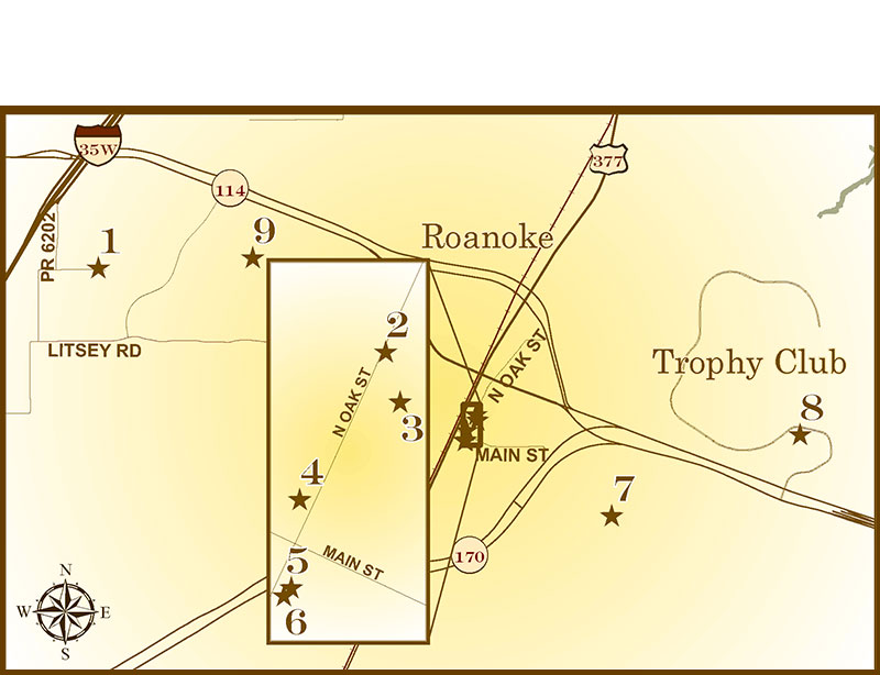
legend - Roanoke, Trophy Club & Area
1. Elizabeth Cemetery
2. Roanoke Lodge
No. 668, A.F. & A.M.
3. Silver Spur
Saloon
4. Old
Continental State Bank
5. Roanoke Water
Tower
6. Roanoke
7. Roanoke
I.O.O.F. Cemetery
8. Medlin Cemetery
9. Litsey Road Bridge at Henrietta Creek |
|
| Type: |
THC Subject Marker, 1978
|
| Location: |
from from Denton go south on 1-35W, exit SH 114 going east under IH-35W, turn
right at Raceway Drive (first road past service station complex on NE corner of
SH 114), follow Raceway Drive one mile until it dead ends at Cemetery Road, turn
left and proceed less than 1/4 mile, turn left at sign to cemetery, which says
private road, cemetery access only. Roanoke. |
| Marker Text: |
Elizabeth town, settled between 1860 and 1862, became a trade center with
businesses, churches, a school and a Masonic lodge. Family tradition says
William Perry Harmonson (1836-1907) donated land for the 1.5-acre community
graveyard upon the death of his mother Anna (1796-1867). The town began to
decline in 1881 after being bypassed by the Texas and Pacific Railroad. In 1949
former school lands were used to enlarge the cemetery to two acres. Still in
use, this burial ground contains almost 400 graves and is all that remains of
the once thriving village. (1978) |
Historical Narrative: |
Elizabeth Cemetery |
| Pictures: |
      |
|
|
| Type: |
THC Subject Marker, 1990
|
| Location: |
corner of Oak and Austin Streets, Roanoke. |
| Marker Text: |
Chartered in 1888, Roanoke Lodge No. 668 replaced the W. C. Young Masonic Lodge,
which had been meeting in nearby Elizabethtown. Members of the Roanoke Lodge met
in a variety of rented quarters until 1908, when they built a two-story frame
lodge hall. While the first floor of the building was made available to a number
of community groups, the second floor was reserved solely for Masonic use.
Throughout its history, the Roanoke Lodge has been an active force in
educational, civic, and charitable endeavors. (1990) |
| Historical Narrative: |
Roanoke Masonic Lodge |
| Pictures: |
    |
|
|
| Type: |
THC Recorded Texas Historic Landmark, 2009
|
| Location: |
114 North Oak Street, Roanoke. |
| Marker Text: |
Swedish stone Mason Lawrence Olson constructed this building for brothers R. M.
And B. S. Snead in 1886, who built it to house the Silver Spur Saloon. The
building was sold upon R. M. Snead's death in 1911 and later served as a
hardware store and grocery. The two-story building is the oldest extant
commercial building in the community, with a main facade of cut sandstone
quarried from local ranch land, arched windows and keystones, a belt course and
corbels of limestone, and side and rear load-bearing walls composed of rubble
stone. Metal threshold plates are inscribed with the Snead brothers' names.
Recorded Texas historic landmark - 2009 Marker is Property of the State of Texas |
Historical Narrative: |
Silver Spur Saloon Historical Narrative |
| Pictures: |
      |
|
|
| Type: |
Listed in the National Register of Historic
Places, 1986
|
| Location: |
109 North Oak Street, Roanoke. |
| Marker Text: |
Entered in the National Register of Historic Places, 1986. |
Historical Narrative: |
Old Continental State Bank |
| Pictures: |
    |
|
|
| Type: |
THC Recorded Texas Historical Landmark, 2010
|
| Marker Text: |
Built during the great depression, the Roanoke Water Tower was the town's
primary water source. Hugh W. Jenkins, Roanoke's first mayor, advocated for
a well and water system to help the newly-incorporated community grow. In
1934, he consolidated Roanoke's water system under the city and applied for
Public Works Administration funding, which was granted and used for the
tower's 1936 construction. Approximately 150 feet tall, the tower contains a
100,000 gallon capacity steel tank and stands on four steel legs. Though no
longer in use, the tower was a vital part of Roanoke's growth and remains a
local landmark.
Recorded Texas Historic Landmark - 2010, Marker is Property of the State of
Texas |
| Location: |
104 South Oak Street in Heritage Place, Roanoke. |
Historical Narrative: |
Roanoke Water Tower Historical Narrative |
| Pictures: |
        
       |
|
|
| Type: |
THC Subject Marker, 2008
|
| Location: |
108 South Oak Street in Heritage Place, Roanoke. |
| Marker Text: |
In 1881, the Texas & Pacific railroad came through here and established this
community, named by a railroad surveyor from Roanoke, Virginia. Settlers lived
in the area before the town was platted, arriving as early as 1847. Many of
these residents relocated to Roanoke from nearby communities such as Garden
Valley (originally Medlin settlement) and Elizabethtown. Situated halfway
between Fort Worth and Denton, Roanoke served as a shipping hub for ranching and
agriculture. There were a number of large ranches in the area, and the railroad
allowed ranchers to ship cattle profitably to markets in the north .Roanoke's
stock pens held the cattle before they were shipped. Area farmers, many of whom
had previously practiced subsistence farming, also made use of the railroad.
Wheat and cotton were the primary crops. Roanoke grew steadily throughout the
1800s. By 1890, the town had four churches, a school, a cotton gin and several
businesses. By the early 1900s, Roanoke's economy diversified and the town
boasted a newspaper, a bank, a grain elevator and the Denton Oil and Gas
Company. Early vital figures in the town included rancher Sam Reynolds, John
(Bob) and Almeadia Jones, whose property was used as a stop on the Underground
Railroad, and Hugh W. Jenkins, storeowner and Roanoke's first mayor.
Transportation further developed when the Texas Highway Department completed the
Northwest Highway in 1932. In 1939, the city received state and federal funds to
construct U.S. Highway 377 along Front Street. Roanoke incorporated in 1933 and
continued its steady growth throughout the 20th century. Today, Roanoke
continues to be a community that treasures its rich historic heritage. (2008)
Marker is Property of the State of Texas |
Historical Narrative: |
Roanoke Historical Narrative |
| Pictures: |
     |
|
|
| Type: |
THC Subject Marker, 1985
|
| Location: |
from Roanoke, follow Main Street southeast out of town; pass SH 170 about 1.5
miles to cemetery on north side of road. Roanoke and Westlake. |
| Marker Text: |
Although few records exist of the Roanoke I.O.O.F. (Independent Order of Odd
fellows) Lodge No. 421, it is known that lodge members purchased land at this
site in 1897 for use as a burial ground. Consisting of approximately five and
one-half acres, the cemetery always has been maintained as a public graveyard
and never was limited to the families of lodge members. Memberships in the
Roanoke Lodge eventually were transferred to Denton along with those of other
rural I.O.O.F. Lodges. The first person buried here was James DeWitt Pressley,
who died in 1897. One tombstone bears an earlier date, however. Mrs. Calvin
Abner Sams was buried on family property upon her death in 1882, but she was
reinterred in the Roanoke Cemetery in 1914. Near the trunk of the "Hanging Tree"
in the northeast section of the graveyard is the burial site of an alleged horse
thief, who was hanged there in 1906. Another section was reserved for the
families of the crew who worked on the railroad here during the 1920s. A
reminder of the area's early history, the cemetery contains the graves of many
pioneers, including members of the Sams, Fanning, Cowan, Seagraves, Buell,
Lassen, Boutwell, Taylor, Mitchell, and McMahon Families. (1985) |
| Historical Narrative: |
International Order of Odd Fellow Cemetery Roanoke |
| Pictures: |
 |
|
|
| Type: |
THC Subject Marker, 1977
|
| Location: |
1.5 miles east of Roanoke on SH 114, go north on Trophy Club Drive about .7 of a
mile to cemetery on south side of road; across from Trophy Club Country Club,
Trophy Club. |
| Marker Text: |
In 1847 Charles Medlin (1807-1864) and his wife Matilda (Allen) migrated from
Missouri with their household and 20 other families to take up land grants on
Denton Creek. Also in the wagon train and colony were Charles Medlin's widowed
mother and his brother Lewis. Floods broke up the first Medlin settlement, at
times called "Garden Valley." Moving to higher grounds in this vicinity, the
settlers formed a new neighborhood that was to grow into the town of Roanoke
(1.5 miles west). Charles Medlin's daughter Mittie Ann (Born 1828) admired the
beauty of this hill, saying she would like to be buried here. The cemetery was
opened at her death in April 1850. Her parents, 13 brothers and sisters, and
many other close relatives also rest here along with neighbors and others from
the locality. This is one of the oldest cemeteries in Denton county. In 1900
James W. Medlin, son of the original land donors, Charles and Matilda Medlin,
enlarged the area to more than ten acres, and began selling lots to bring in
maintenance funds. Medlin Cemetery Association was formed in 1947. A new access
boulevard and other improvements were provided for this cemetery in the 1970s.
(1977) |
Historical Narrative: |
Medlin Cemetery |
| Pictures: |
   |
|
back to top
Argyle,
Justin, Ponder, Krum & Area
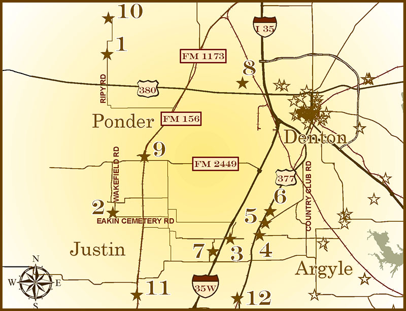
legend - Argyle,
Justin, Ponder, Krum & Area
1. Gregg Ranch
2. Eakins Cemetery
3. Johns' Well
and Campgrounds
4. Argyle
5. Graham-Argyle
Cemetery
6. Argyle United
Methodist Church
7. Prairie Mound
Cemetery
8. Texas Ag
Experiment Station #6
9. Ponder
10. Plainview Cemetery
11. Justin
12. Sam Bass Road Bridge at Duck Creek
13. City of Krum
|
|
| Type: |
THC Subject Marker, 1973
|
| Location: |
from IH-35 in Denton, go west on US 380 about 8.6 miles, turn north on Ripy Road
(at Muslin Cemetery), proceed about 1.7 miles to entrance of ranch on west side
of road. Krum area. |
| Marker Text: |
Darius Gregg (1804-70), who came to Texas from Kentucky in 1827, and fought in
the Texas War for Independence, accumulated about 20,000 acres in this area in
the early 1850s. Gregg, a surveyor and Houston Realtor, spent several summers
here before his death. His son, William Bowen Gregg (1849-89), moved from
Houston and operated the ranch in 1870s and early 1880s. Notorious outlaw Sam
Bass worked on the ranch, and a frequent summer visitor was Robert Swift, of the
well known meat packing family. Of the original ranch, 750 acres are still owned
by a Gregg heir. (1973) |
| Historical Narrative: |
Darius Gregg Ranch |
| Pictures: |
     |
|
|
| Type: |
THC Subject Marker, 1995
|
| Location: |
3 miles south of Ponder on FM 156, west on Eakins Cemetery Road, and north on
Wakefield. Cemetery is on west side of road, Ponder. |
| Marker Text: |
Noah (1810-1868) and Susan (1816-1878) Eakins and their family came to this part
of Denton County from Kentucky in 1855. This cemetery was established on their
land about 1855-58 when a neighbor, Angelina Rayburn, was fatally burned while
cooking on an open fire. Lula Q. Porter, infant child of another pioneer family,
was buried in the graveyard in 1861, and the site became a community burial
ground known as Eakins Cemetery. It is the final resting place of the Eakins
family and many other area pioneers and their descendants. It continues to serve
the rural community. (1995) |
Historical Narrative: |
Eakins Cemetery |
| Pictures: |
   |
|
|
| Type: |
THC Subject Marker, 1982
|
| Location: |
intersection of Old Justin Road and C. Taylor Road (just east of IH-35W) 2 miles
west of Argyle via Old Justin Road, Argyle. |
| Marker Text: |
In 1884 this site was designated as a religious campground by the members of the
Prairie Mound Methodist Church. Johns' well, named for former owner Hardin
Johns, provided the steady water supply needed by campers, area settlers and
travelers. During annual ten-day camp meetings, families camped around the brush
arbor where services were held. As nearby communities erected church buildings
the campgrounds began to decline and the land was sold in 1913. Johns' well
continued to serve the area residents until 1963. (1982) |
Historical Narrative: |
Johns' Well and Campgrounds |
| Pictures: |
    |
|
|
| Type: |
THC Subject Marker, 1981
|
| Location: |
Moved from US 377 to 308 Denton Street, Argyle Town Hall, Argyle. |
Historical Narrative: |
Argyle |
| Marker Text: |
This area was first settled in the 1850s by members of the Peters Colony. In
1881 the town of Argyle was started by Galveston developer James Morrill, when a
rail line was built through the area. Early residents came from neighboring
settlements. Schools consolidated with Argyle included Beulah, Pilot Knob,
Stoney Ridge, Lane, and parts of the Prairie Mound and Litsey Districts. An 1895
fire destroyed the business area, but it was soon rebuilt. The growth of nearby
urban areas, which led to a decline before World War II, has resulted in recent
population increases. (1981) |
| Pictures: |
        |
|
back to top
|
| Type: |
THC Subject Marker, 1976
|
| Location: |
on Country Club Road about 1/2 mile east of US 377 on north side of road; 1/2
mile north of Argyle. |
| Marker Text: |
This burial ground served the farming community of Graham which grew up here
after the Civil War. First known interment was that of an infant, George Isbell,
on December 10, 1865. An adjacent structure housed a school and Graham Baptist
Church. After 1881, most of the settlers moved to the nearby town of Argyle on
the Texas and Pacific Railroad. The school and church were moved in 1887 after
their meeting place burned. In 1888 this property was deeded for cemetery use by
C. N. Jarrell. In 1974 volunteers began restoration of the plot, which has about
238 marked graves. (1976) |
Historical Narrative: |
Graham-Argyle Cemetery |
| Pictures: |
   |
|
|
| Type: |
THC Subject Marker, 1981
|
| Location: |
9033 Fort Worth Drive (US 377), marker moved from original location at 308
Denton Street to new church in 2009, Argyle. |
| Marker Text: |
Organized thirteen years after the town of Argyle was founded, this church was
chartered in 1894 with twenty-seven members. The first pastor was the Rev.
Blueford Henry Webster, a Methodist circuit rider from Mississippi. Early
worship services for the congregation were conducted in the Argyle Schoolhouse.
In 1898 church trustees purchased land at this location from the Texas and
Pacific railway and W. H. Abrams, company trustee. The first sanctuary, a frame
structure, was built here soon afterward during the pastorate of the Rev. J. R.
Atchley, who completed much of the carpentry work with the assistance of a Mr.
Rhodes and several church members. Adjoining property was acquired by church
trustees in 1947. A brick sanctuary was constructed here in 1969, east of the
original structure, and an educational building was added in 1972. Part of a
circuit for seventy-eight years, the Argyle United Methodist Church has played a
significant role in the development of the town. Membership has included many
prominent community leaders, and church facilities have been used for a variety
of civic group meetings and public functions. (1981). Argyle United Methodist
Church moved from 308 Denton street to this site on Palm Sunday, April 5, 2009. |
Historical Narrative: |
ARGYLE UNITIED METHODIST CHURCH |
| Pictures: |
      |
|
|
| Type: |
THC Subject Marker, 1981
|
| Location: |
1/2 mile north of FM 407, 4 miles southwest of Argyle on Prairie Mound Cemetery
Road, Argyle area. |
| Marker Text: |
This burial ground was in use by 1882 when adjoining property was deeded to the
Prairie Mound Methodist Episcopal Church, South. The earliest marked grave here
is that of Edgar Myers (1875-1878), the son of J. E. and M. J. Myers. Church
services were discontinued before 1920, and a public school, organized nearby in
1878, was consolidated with neighboring districts in the 1940s. Shortly after
the original sanctuary was removed from the site in 1961, the Lark Heath
Memorial Chapel was dedicated. Many pioneer settlers of the Argyle-Justin area
are buried here. (1981) Incise on back: Donated by J. Heath Family, Argyle
Centennial Committee |
| Historical Narrative: |
Prairie Mound Cemetery |
| Pictures: |
   |
|
back to top
|
| Type: |
THC Subject Marker 2011
|
| Location: |
northeast corner of Masch Branch and Hampton Roads; from Denton exit I-35 at US 380, turn west, go 1.3 miles to Masch Branch Road, turn north and go .5 mile to intersection of Masch Branch and Hampton Road, Denton |
| Marker Text: |
During Denton County's early years, farming and ranching were the traditional pursuits. When the railroads entered the county, subsistence farming gave way to farming that yielded money-making crops that could be shipped to various markets. In 1887, the U.S. government passed the Hatch Act to appropriate funds to states that promoted scientific experimentation regarding agriculture. Over the next twenty years, experiment stations were established throughout the state. In 1910, the area received notice that a station would be located in Denton, known as Station No. 6. The Chamber of Commerce offered a site west of Denton owned by J.N. Rayzor that the station occupied for the first few years. However, because of soil issues, the state bought the J.T. Luper farm five miles northwest of Denton in 1913 and moved the station there.
The station specialized in research on ways to improve grains and their resistance to weather and disease. The station's success was evident in the new varieties of oats developed that could withstand North Texas' sometimes severe winters. Nortex, New Nortex, Mustang and Alamo were a few examples of the new varieties of oats. They doubled yields and also helped overcome the problem of rust damage. The station also produced wheat varieties such as Westar, Quanah and Frisco, and barleys such as Texan and Cordova. The station led to the establishment of agricultural-related industries that bought and sold seed, plants, fertilizer, mills, tools and other sales, and added growth to the regional economy. Many farmers depended on the station for advice on their farming operations but after 62 years, the station was closed in 1972 and activities were moved to a regional agricultural research center. 175 years of Texas independence * 1836-2011 Marker is Property of the State of Texas |
Historical Narrative: |
Texas Agricultural Experiment Station #6 Historical Narrative |
| Pictures: |
   |
|
back to top
|
| Type: |
THC Subject Marker, 2011
|
| Location: |
At flag At flag pole in the 100 block of West Bailey Street (Ponder's main
street), which intersects with FM 156, Ponder. |
| Marker Text: |
Settlers began to arrive in western Denton County in the 1850s in search of rich
agricultural land. Silas Christal (1810-1883), his wife, Mary Elizabeth
(Burnett) (1811-1883), and their twelve children arrived in 1855 from Missouri.
Christal built an ox-driven mill to grind corn and, in 1880, built a school on
his property. The town of Gerald was established in 1886 when the Gulf,
Colorado, and Santa Fe Railway decided to create a line from Fort Worth to
Indian Territory in present-day Oklahoma. Another town in Texas was named
Gerald, so the town was renamed Ponder in honor of William A. Ponder
(1884-1911), a prominent landowner. The Denton Creek system provided settlers
with ample resources and fertile land for agricultural production of wheat,
corn, oats, and cotton. In the late 1800s, churches formed to serve the growing
community and included a Baptist Church, Methodist Church, and Church of Christ.
In 1894 Cornelius N. Skaggs (1869-1938) opened the first business in Ponder, a
store and post office, and became the second postmaster. The town quickly grew
around the railway and included general stores, a lumber yard, cotton, gin,
mill, a bank and a hotel. In 1897, one of the area's largest landowners, H.F.
Wakefield, donated land for a school. Community activities, such as boys high
school basketball and the Ponder Rodeo, organized in 1939 by Chester January,
Sidney Ford, and Dr. M.L. Holland, have brought the town together since the
1930s and 1940s. These local activities, businesses, education, and religious
groups continue to represent the traditions and spirit of this small, rural
town, incorporated in 1966.
175 years of Texas independence * 1836-2011. Marker is property of the state of
Texas. |
Historical Narrative: |
Ponder Historical Narrative |
| Pictures: |
    |
|
back to top
|
| Type: |
Historic Texas Cemetery Designation, 2012; Historic Texas Cemetery Marker, 2012
|
| Location: |
from intersection of FM 156 and FM 1173 in Krum, go 5.2 miles west on FM 1173. Cemetery is on South side of FM 1173 behind Plainview Baptist Church, Krum Area. |
| Marker Text: |
Located in Western Denton County, Plainview Cemetery served as a burial ground for early settlers in the area. The Plainview Community began around 1878 when the families of Gideon Kimbrough (1833-1923) and William Kimbrough (1824-1912) and their families arrived from Bellville Tennessee. As the community grew, the need for a school was recognized and a one-room school building was erected. In 1894, a Baptist Sunday School began to meet in the building. The Plainview Baptist Church formed in 1896 and built a church on land donated by C. R. Moreman. In 1898, a plot of land adjoining the church was purchased from the estate of James B. Walker (1848-1898) to be used as a cemetery. Mr. Walker was the first burial in the cemetery. It became the only cemetery for the Plainview Community.
At least five people from the area were buried in the cemetery prior to 1900. A large increase in burials took place in the early 1900s because of a national influenza epidemic. The cemetery has a variety of marble and cement headstones marked with biblical scripture, Masonic markings, Woodmen seals and military headstones. Many founding families of the community have gravesites in the cemetery as well as generations of their descendants. Maintained by the Plainview Cemetery Association, the graves provide a record of the settlers of the area, including teachers, preachers and veterans. The Plainview Baptist Church and the cemetery are the only remnants of this once flourishing farming community. Historic Texas Cemetery – 2012 Marker is Property of the State of Texas |
Historical Narrative: |
Plainview Cemetery Historical Narrative |
| Pictures: |
 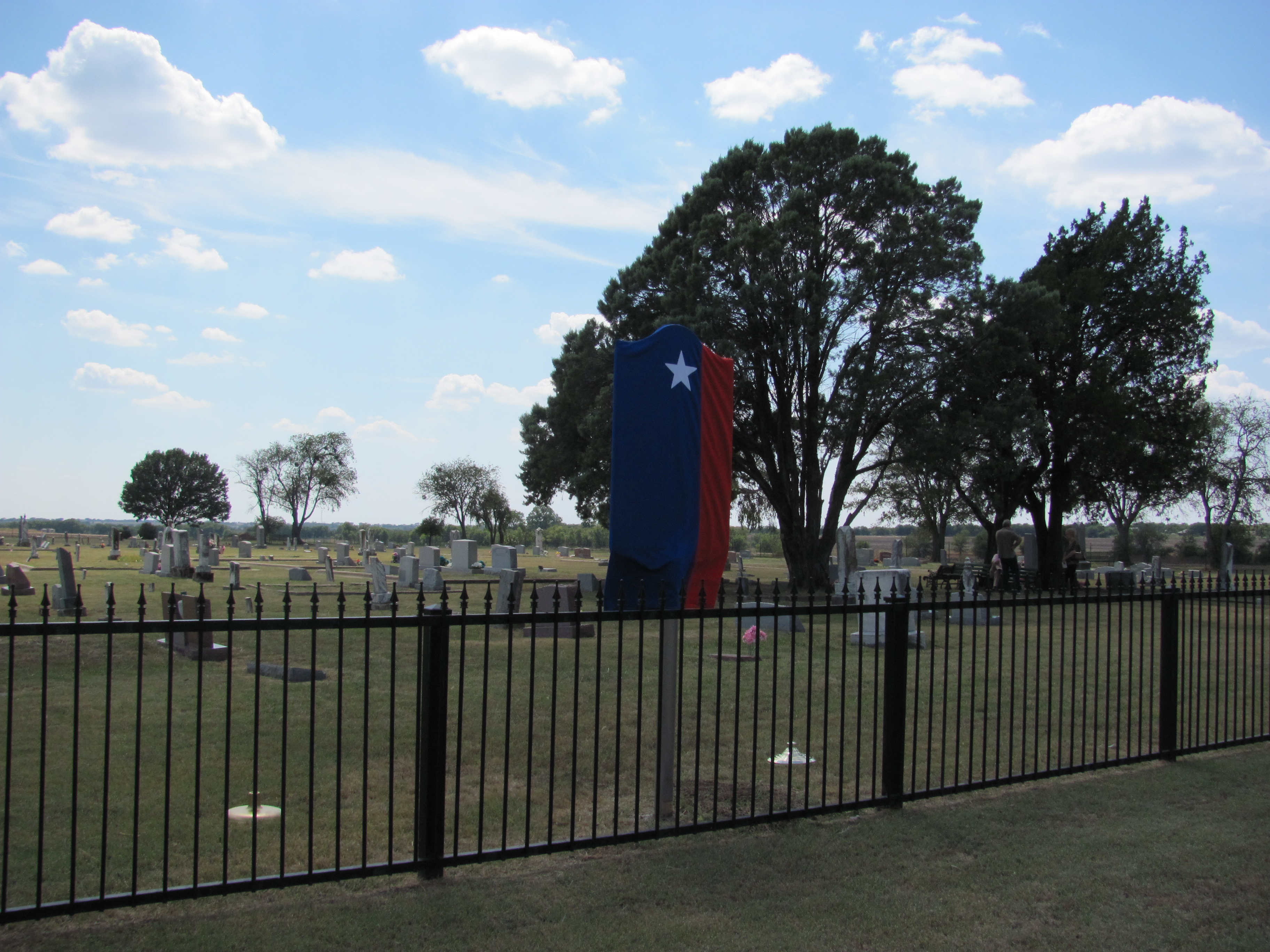  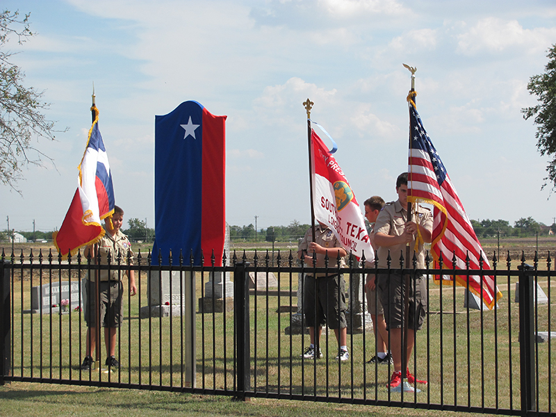  |
|
back to top
|
| Type: |
THC Subject Marker 2014
|
| Location: |
Bishop Park at 580 South FM 156 in Justin. Directions: Bishop Park is located within city limits of Justin on west side of FM 156 approximately 1 mile south of the intersection of 1st street and FM 156. |
| Marker Text: |
Located in the rich, fertile, softly rolling prairie land of North Central Texas, Justin is situated at the confluence of the Denton, Oliver and Trail Creeks. For many years native American Tribes flourished in the area. In 1841, John B. Denton was killed near Fort Worth in the Village Creek Battle and was buried in an unmarked grave at the juncture of Denton and Oliver Creeks. Twenty years later his remains were moved to Bolivar and in 1901 he was reinterred on the grounds of the county courthouse. That same creek juncture was the site of an 1848 Icarian settlement of French Socialist immigrants who were allocated thousands of acres by the Peters Colony. Because of strife with Peters and harsh conditions, the settlement was abandoned within two years. In the mid-1800s, as settlers came to the area from Missouri and other states, the Texas Rangers posted at Hickory Station were able to provide some protection for the settlers to establish the land for ranching and farming. Wheat, corn and cotton grew easily in the rich soil of the agricultural area. .
Justin was an important stop on the Gulf,Colorado & Santa Fe Railway. One of the men responsible for the railroad coming through Justin was Walter Justin (W. J.) Sherman, chief construction engineer, for whom the town was eventually named. Businesses soon opened up and thrived in this small town, which by 1940 had four elevators, two cotton gins, a flour mill and over twenty other businesses. The Justin State Bank remains a locally owned, managed and operated financial institution since its doors opened in 1904. The city of Justin incorporated in 1946 and has continued to grow, offering a historical perspective and modern quality of life to new generations of settlers. (2014) Marker is property of the state of Texas. |
Historical Narrative: |
Justin Historical Narrative |
| Pictures: |
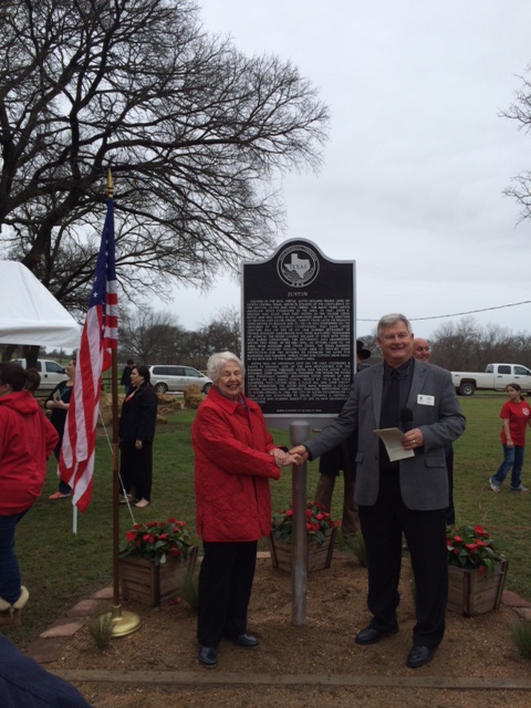 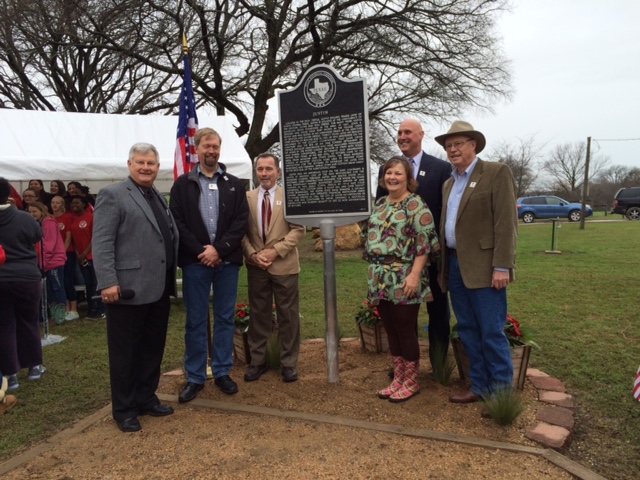 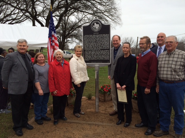 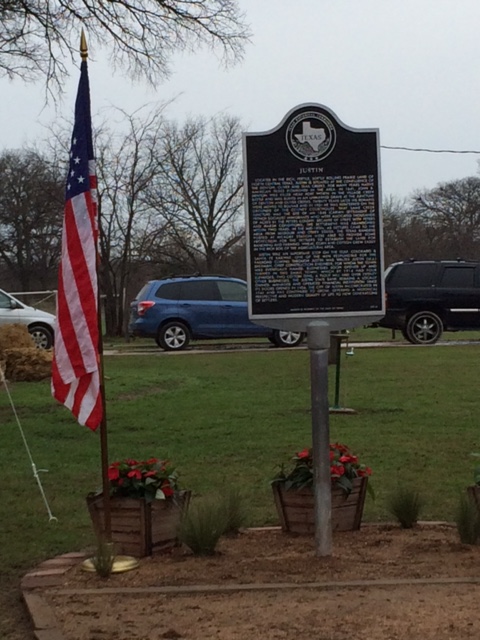 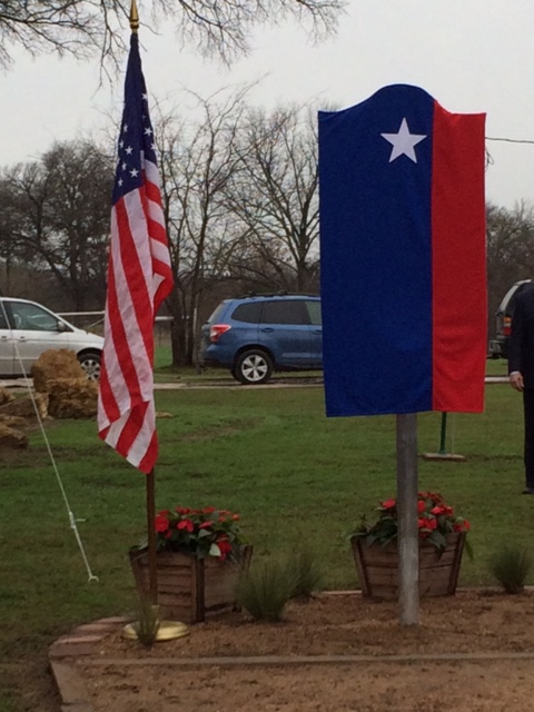 |
|
back to top
|
| Type: |
DCHC, 2016 |
| Location: |
Bridge relocated to Denton County Southwest Courthouse at 6200 Canyon Falls Drive in far west Flower Mound, off HWY 377 |
| Marker Text: |
NA |
Historical Narrative: |
Sam Bass Road Bridge at Duck Creek |
|
Pictures:
| |
|
back to top
|
| Type: |
THC Subject Marker, 2017 |
| Location: |
Krum, Texas |
| Marker Text: |
LOCATED IN WEST-CENTRAL DENTON COUNTY, THE CITY OF KRUM BEGAN AS A PIONEER SETTLEMENT, KNOWN AS THE JACKSON COMMUNITY, NEAR PRESENT-DAY KRUM JACKSON CEMETERY IN 1876. SOON, THE FAMILIES DECIDED TO ESTABLISH A SCHOOL. MR. AND MRS. J.J. BARRETT AND C.H. JACKSON DEEDED LAND FOR THE SCHOOL AND A CEMETERY.
THE TOWN OF KRUM WAS FOUNDED IN 1886 WHEN THE GULF, COLORADO, AND SANTA FE RAILWAY PURCHASED ACREAGE FROM LOUIS L. AND GABRILLA FINLEY FOR THE TOWN SITE, NAMED IN HONOR OF CHARLES K. KRUM, A RAILROAD OFFICIAL. BUSINESSES QUICKLY OPENED AND A HOME FOR THE STATION AGENT WAS BUILT IN TOWN. THE POST OFFICE WAS ESTABLISHED IN 1888 AND WAS FIRST HOUSED IN THE FINLEY STORE WITH S.D. CHADWELL SERVING AS THE FIRST POSTMASTER UNTIL MR. FINLEY TOOK OVER LATER THAT YEAR. A HARDWARE STORE, BLACKSMITH SHOP, SALOON, DRUG STORE AND A HOTEL OPENED TO SERVE THE GROWING TOWN.
TO SERVE THE COMMUNITY’S SPIRITUAL NEEDS, THE FIRST BAPTIST CHURCH ORGANIZED IN 1882 IN THE JACKSON SCHOOLHOUSE, AND IN 1891 THE METHODIST CHURCH MOVED FROM THE JACKSON COMMUNITY TO KRUM. THE CHURCH OF CHRIST OF KRUM WAS ESTABLISHED IN 1893 AND THE PRESBYTERIAN CHURCH IN 1901.
THE RICH SOIL IN THE REGION PRODUCED BOUNTIFUL WHEAT HARVESTS FOR WHICH THE TOWN BECAME FAMOUS, KNOWN AS THE LARGEST INLAND GRAIN MARKET IN THE EARLY 1900s. WHEAT GROWN IN THE AREA EARNED AWARDS, INCLUDING THE GRAND PRIZE FOR THE “RAINBOW FLOUR” AT THE 1904 ST. LOUIS WORLD’S FAIR. AGRICULTURAL PRODUCTION PLANTS AND FACTORIES WERE ESTABLISHED TO PROCESS GOODS, AND BANKS OPENED TO ASSIST FAMILIES AND BUSINESSES IN THE AREA. KRUM WAS OFFICIALLY INCORPORATED IN 1955 AND CONTINUES TO FOCUS ON THE GROWTH OF THIS RURAL TOWN WHILE PRESERVING ITS RICH HISTORICAL HERITAGE.
(2017)
|
Historical Narrative: |
City of Krum |
|
Pictures:
| |
|
Bolivar &
Area
legend - Bolivar & Area
1. Bolivar Cemetery
2. Townsite of
Bolivar
3. Forester
Ranch
4. Home of John Simpson Chisum |
|
| Type: |
THC Subject Marker, 1998; Historic Texas Cemetery Marker, 1997
|
| Location: |
south side of FM 455, 3.7 mile west of IH-35, adjacent to old Bolivar Baptist
Church, Bolivar. |
| Marker Text: |
The town of Bolivar was laid out by Dr. Hiram Daily in 1852 with a
burial plot on high ground nearby. Though the site had probably been used as a
burial ground for many years, the earliest marked grave is that of 4-month-old Zolly Cofer Waide, who was born and died in 1863. G. A. Grissom, a prominent
Bolivar Masonic leader, died in 1876. After his interment, Bolivar Lodge No.
418, A. F. & A. M. and the Independent Order of Odd Fellows Lodge No. 221 set
aside five newly purchased acres, including the graveyard, for community
burials. A decorative fence was installed across the front of the cemetery in
that year. Many monuments were erected by the Woodmen of the World organization.
Many of the nine adults and eight infants buried in 1892 were victims of a
nationwide influenza epidemic. Another influenza epidemic in 1918 claimed more
lives. Bolivar citizens of all walks of life were buried here. Some were members
of farming and ranching families; others were business people, educators,
physicians, and ministers. They include veterans of the Mexican War, the Civil
War, World War I, World War II, the Korean War, and the Vietnam War. Operated by
the board of trustees of the Bolivar Cemetery Association, the graveyard
continues to serve area residents, many of whom are descendants of those who
shaped the history of Bolivar and Denton County. The burial ground remains a
record of the pioneer settlers of the area. (1998) |
Historical Narrative: |
Bolivar Cemetery |
| Pictures: |
  |
|
|
| Type: |
THC Subject Marker, 1970
|
| Location: |
SE corner of the intersection of FM 2450 and FM 455, Bolivar. |
| Marker Text: |
Named indirectly for Simon Bolivar, South American statesman, general and
patriot. It might have been called "New Prospect," but for a mug of rum. When
town was founded in 1852, a man who had settled here from Bolivar, Tenn., wanted
to name the community in honor of his hometown. But a preacher-doctor insisted
that it be named New Prospect. An election was called to settle the matter and
the Tennessean exchanged mugs of rum for votes, Bolivar won. During the 1800s,
Bolivar was the westernmost fort in Denton County and the first settlement west
of Collin County. Two stagecoach lines changed horses here. The town thrived and
could count three hotels, several stores, a gin, a flour mill, a sawmill, a
blacksmith shop, a saloon, a church and a school. It was here that the Texas
cattle trail joined the Jesse Chisholm Trail, but it was John Chisum, Texas
cattle baron, who had herds here and furnished beef to the Confederacy during
the Civil War. Bolivar and the surrounding area were havens for Sam Bass and his
men. Two Bolivar men were jailed in 1890 for harboring notorious marauders. Many
early settlers (whose descendants still live here) played important roles in
development of county. |
| Historical Narrative: |
Town of Bolivar |
| Pictures: |
 |
|
back to top
|
| Type: |
THC Subject Marker, 1987
|
| Location: |
7.5 miles west of Sanger on FM 455 at entrance to ranch, Bolivar. |
| Marker Text: |
William S. William S. Forester brought his family to Denton County from Tennessee
in the early 1850s, and established a ranch about 1852. He was assisted in his
ranching operation by his sons, one of whom, Sol, was killed by Indians at the
age of sixteen while herding cattle on the ranch. Following William Forester's
death the ranch was operated by his son, Lock S. Forester (1844-1913). A
Confederate veteran, Lock Forester increased the size of the ranch to over 6,000
acres. Under his management the ranch's "Two I Jinglebob" brand became well
known. He supervised the ranch interests until 1890, when he moved to Denton. Ed
W. Forester, son of Lock Forester, assumed management of the ranch in 1890. In
1913 the ranch was divided into sections, with Lock S. Forester's three children
each receiving one-third of the ranch property. Ed Forester became a successful
rancher in his own right, raising champion shorthorn cattle as well as quarter
horses, sheep, and other livestock. He served two terms as Denton County
Commissioner. The Forester Ranch has been an important part of the history of
Denton County for over a century. (1987) |
Historical Narrative: |
Forester Ranch |
| Pictures: |
   |
|
|
| Type: |
Texas Centennial Marker, 1936
|
| Location: |
from the intersection of FM 455 and 2450, go north on FM 2450 3 miles to Chisum
Road, go west on Chisum .6 mile (sharp curve) then go west on Jingle Bob Trail
one mile across dam, Bolivar. |
| Marker Text: |
Here stood the home from 1856 to 1862 of John Simpson Chisum, cattle king. Born,
August 16, 1824; Died, September 22, 1884 at Paris, Texas. (3 mi. N of Bolivar,
Denton County) |
| Pictures: |
    |
|
back to top
Sanger & Area
legend - Sanger
& Area
1. Tyson Cemetery
2. Noah C. Batis
3. William E. Partlow, First Mayor of Sanger
4. Jacob Fredrick Elsasser
5. Sanger Presbyterian Church
6. Sanger and the Gulf, Colorado and Santa Fe Railway
7. Galilee Missionary Baptist Church
8. Rector Road Bridge
9. Gribble Springs Baptist Church
10. Gregory Road Bridge at Duck Creek |
|
| Type: |
THC Subject Marker, 1976
|
| Location: |
from Sanger go north on IH-35/U.S. 77 about 4.6 miles south to FM 3002, go east
on 3002 about 5.5 miles to FM 3442, in about 1.4 miles, FM 3442 becomes Sullivan
Road and tees into Tyson Lane; turn east on Tyson to cemetery, Sanger area. |
| Marker Text: |
J. P. Newton (1821-56), a settler from Tennessee, is the earliest known burial
in this cemetery. Charles Hammons (1854-64) has the second oldest stone. He was
a grandson of another Tennessean, Charles Lee Sullivan (1810-68), a leader in
this community. This burial ground, bought 1869 by Mr. and Mrs. G. W. Hammons,
Sullivan's son-in-law and daughter, later was donated to the public by James R.
Tyson (1829-99), father of Sullivan's daughter-in-law, Angeline Tyson Sullivan.
There are 44 Sullivan graves in 1976. An active cemetery association maintains
this burial ground (1976) |
| Historical Narrative: |
The Tyson Cemetery |
| Pictures: |
     |
|
|
| Type: |
THC Subject Marker, 1986
|
| Location: |
one mile west of Sanger on FM 455, across from elementary school; marker is
missing, Sanger. |
| Marker Text: |
A native of Illinois, Noah C. Batis (1860-1950) came to Texas at an early age.
In 1881 and 1882, he worked as a cowboy driving cattle up the Chisholm Trail to
Kansas. He came to Sanger in 1889 and ten years later, at this site, established
the Sanger Stock Farm, which became known for its fine horses, mules, and other
livestock. Although he lacked the formal training, Batis provided veterinary
care for his animals and for those of nearby farms. A county commissioner from
1919 to 1923, he lived here with his wife Laura (b. 1864). They died in 1950.
Texas Sesquicentennial 1836-1986 |
| Historical Narrative: |
Noah Batis |
| Pictures: |
   |
|
|
| Type: |
THC Subject Marker, 1976
|
| Location: |
611 West Plum Street (Seventh and Plum); marker is missing and house was torn
down, Sanger. |
| Marker Text: |
A Virginian and a soldier who surrendered at Appomattox with Gen. Robert E. Lee,
W. E. Partlow moved to Texas after the Civil War (1861-65). He married Nancy
Jane Sullivan (1860-1922), daughter of Denton County pioneers, Mr. and Mrs. Jack
Sullivan. Partlow, a merchant, was elected first mayor when Sanger was
incorporated in 1892. He built this house for his family in 1904. From 1907 to
1913, they lived in New Mexico, where Partlow was commissioner of U.S. Circuit
and district courts. After returning to Sanger, he served as Justice of the
Peace and died here. (1976) |
| Historical Narrative: |
Partlow House |
| Pictures: |
   |
|
|
| Type: |
THC Subject Marker, 1976
|
| Location: |
603 North Seventh Street (corner of Seventh and Peach), Sanger. |
| Marker Text: |
Born in Germany in 1834, Jacob Frederick Elsasser migrated to this country with
his father and brothers. They operated a cigar factory in Chicago until it was
destroyed in the great Chicago fire of 1871. Elsasser moved to Texas with his
Swiss-born wife, Catharine (1832-1903), and built a 2-story farm house east of
Sanger. After it burned, they erected this residence in 1901. One of Elsasser's
daughters, Mrs. J. M. Peery, and her family occupied the house until 1939. It
was purchased in 1952 by Mr. and Mrs. Willard Bounds. (1976) |
Historical Narrative: |
Jacob Fredrick Elsasser |
| Pictures: |
   |
|
|
| Type: |
THC Recorded Texas Historic Landmark, 1972
|
| Location: |
Seventh and Elm Streets. Sanger. |
| Marker Text: |
Founded 1896, in 1902 built this structure on land given by Jack R. Sullivan, a
Baptist. With town's best auditorium, this became site of school and civic
programs; elocution and music were taught here. Community bought building when
congregation in 1971 moved to a new church.
Recorded Texas Historic Landmark - 1972 |
| Historical Narrative: |
The Old Presbyterian Church |
| Pictures: |
    |
|
|
| Type: |
THC Subject Marker, 2010
|
| Location: |
100 Bolivar Street, Sanger. |
| Marker Text: |
Sanger originated in 1886 at mile post 392.16 as a water stop along the Gulf,
Colorado and Santa Fe Railway route leading north from Fort Worth to
Purcell, Indian Territory (now Oklahoma). The stop's proximity to north
Denton County cattle ranches and to the Chisholm Trail led the railroad to
construct a side track, cattle pens, loading chute and depot. Mrs. Elizabeth
Bullock Huling, who had sold the property for the railroad stop, soon hired
surveyors to plat a townsite surrounding it. Mrs. Huling donated land for a
wagon yard, well, school, town square, cemetery and Methodist Church. A
saloon, blacksmith shop and the Ready Hotel, which housed the first post
office, opened shortly after the town, originally known as Huling, and later
New Bolivar, was officially named in honor of Sanger Brothers, a prominent
Texas dry goods firm. The town was incorporated in 1892. When an 1890 fire
destroyed much of Sanger, the railroad rebuilt expanded facilities. The 1897
establishment of the Sanger Mill and Elevator Company, home of Silk Finish
Flour, helped to transition Sanger to a farming community. Cattle continued
to drive the community until two meat packing plants were built in Fort
Worth, ca 1900, and ranchers began trucking cattle to market. World War II
increased rail traffic at the depot and operations were taken over by women
as men went to war. Although passenger rail service later ended, the town of
Sanger, which got its start as a railroad water stop, continues to grow and
prosper. (2010) Marker is Property of the State of Texas. |
Historical Narrative: |
Sanger and the Gulf, Colorado and Santa Fe Railway Historical Narrative |
| Pictures: |
    |
|
|
| Type: |
THC Subject Marker, 2009
|
| Location: |
300 East Willow Street, Sanger. |
| Marker Text: |
In 1909, area African Americans organized Galilee Missionary Baptist Church
approx. 2.5 miles south of Sanger of the farm of John W. and Eliza McCarty.
The McCartys had purchased the 750 acre farm in 1900. The congregation moved
to Sanger in 1910 and built a church at this site, which was also used as a
school for their children. In the early 1920s the women of the congregation
raised and sold cotton to buy a church bell which is still rung each Sunday.
When the church house grew too small, a larger one was built in 1957, and
another larger church building was built in 1998. The church contributes to
the community through many outreach and missionary programs.
(2009) Marker is Property of the State of Texas. |
Historical Narrative: |
Galilee Missionary Baptist Church Historical Narrative |
| Pictures: |
    |
|
|
| Type: |
DCHC Marker, 2005
|
| Location: |
2.5 miles SE of Sanger. From Denton go north on IH-35, take Rector Road exit, go
east on Rector until you come to the new bridge that replaced the original
historic iron bridge that spanned Clear Creek, Sanger. |
| Marker Text: |
This bridge replaces a historic Pratt through-truss bridge built in 1907-08. It
was relocated to Guyer High School, Denton, in 2005. Rector Road Bridge at Guyer
High School, 7501 Teasley Lane. Built in 1907. Listed in the National Register
of Historic Places by the United States Department of Interior.
|
| Historical Narrative: |
Historical Narrative |
| Pictures: |
  |
|
|
| Type: |
THC Subject Marker, 2006
|
| Location: |
6933 FM 2164, Sanger. |
| Marker Text: |
Twenty-three members of the congregation from the Pond Creek community
established Gribble Springs Baptist Church in 1871. The Rev. W.C. West served as
the first pastor. Gribble Springs Missionary Baptist Church reorganized in 1896,
and members have remained active from that time forward. The congregation first
met in a schoolhouse, before building a sanctuary in 1904. Since then, the
church building has been replaced twice through the hard work of the membership.
As Denton County becomes increasingly urban, the church continues to serve the
community of Gribble Springs, where it remains a reminder of early life in this
area. (2006) |
Historical Narrative: |
Gribble Springs Baptist Church |
| Pictures: |
   |
|
Historical Marker by
Area:
Denton / Downtown, Courthouse
Square Historic District & Area | Denton/ University of North Texas, Historic District
& Area | Denton / Texas Woman's University and Area | Pilot Point, Aubrey, Green Valley & Area | Little Elm, Oak Grove, Oak Point & Area | Old Alton, Copper Canyon & Area | Lake Dallas, Corinth, Shady Shores & Area | Lewisville & Area | Carrollton, Hebron, The Colony & Area | Flower Mound & Area | Roanoke, Trophy Club & Area | Argyle, Justin, Ponder, Krum & Area | Bolivar & Area | Sanger & Area
Geographical Sections:
Center | Northeast | Southeast | Southwest | Northwest
|


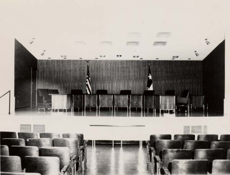
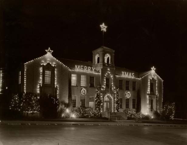
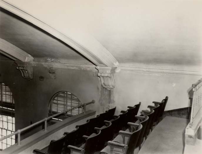
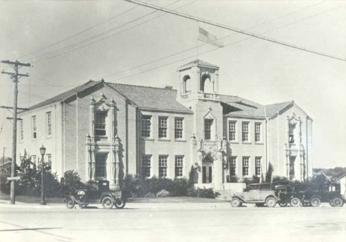
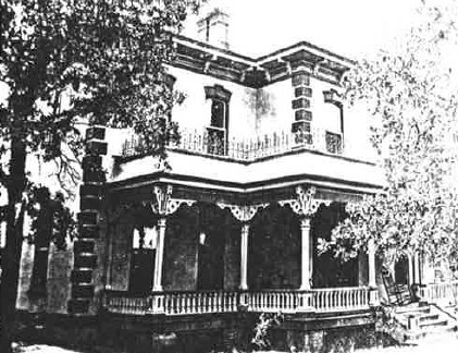


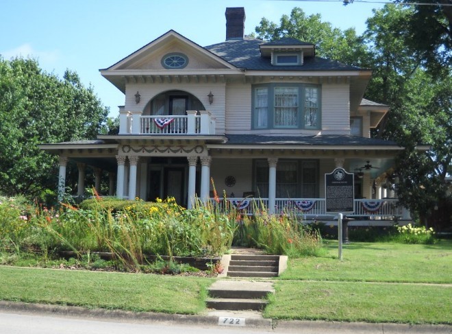
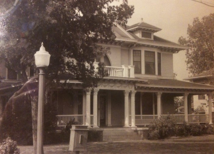
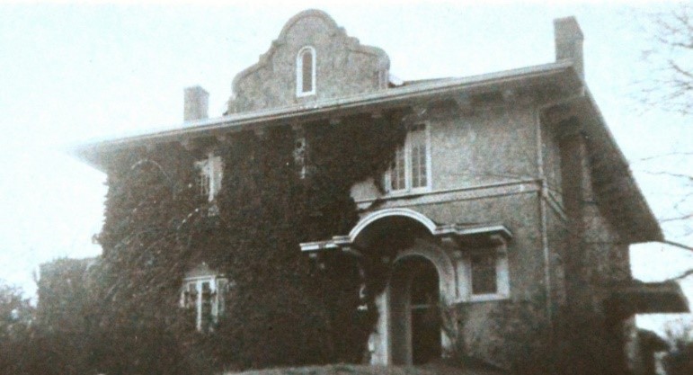
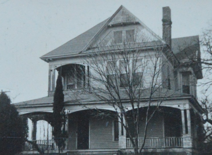
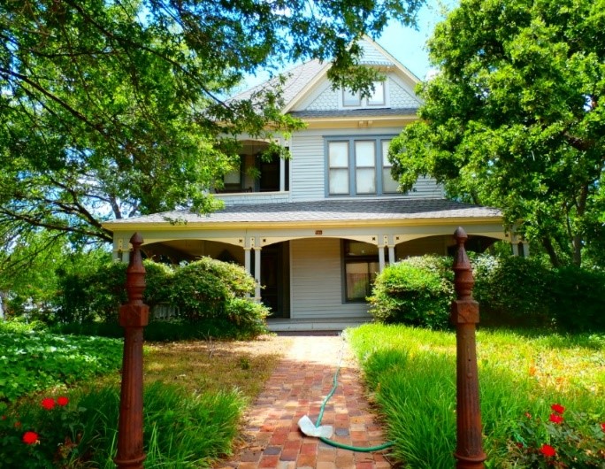
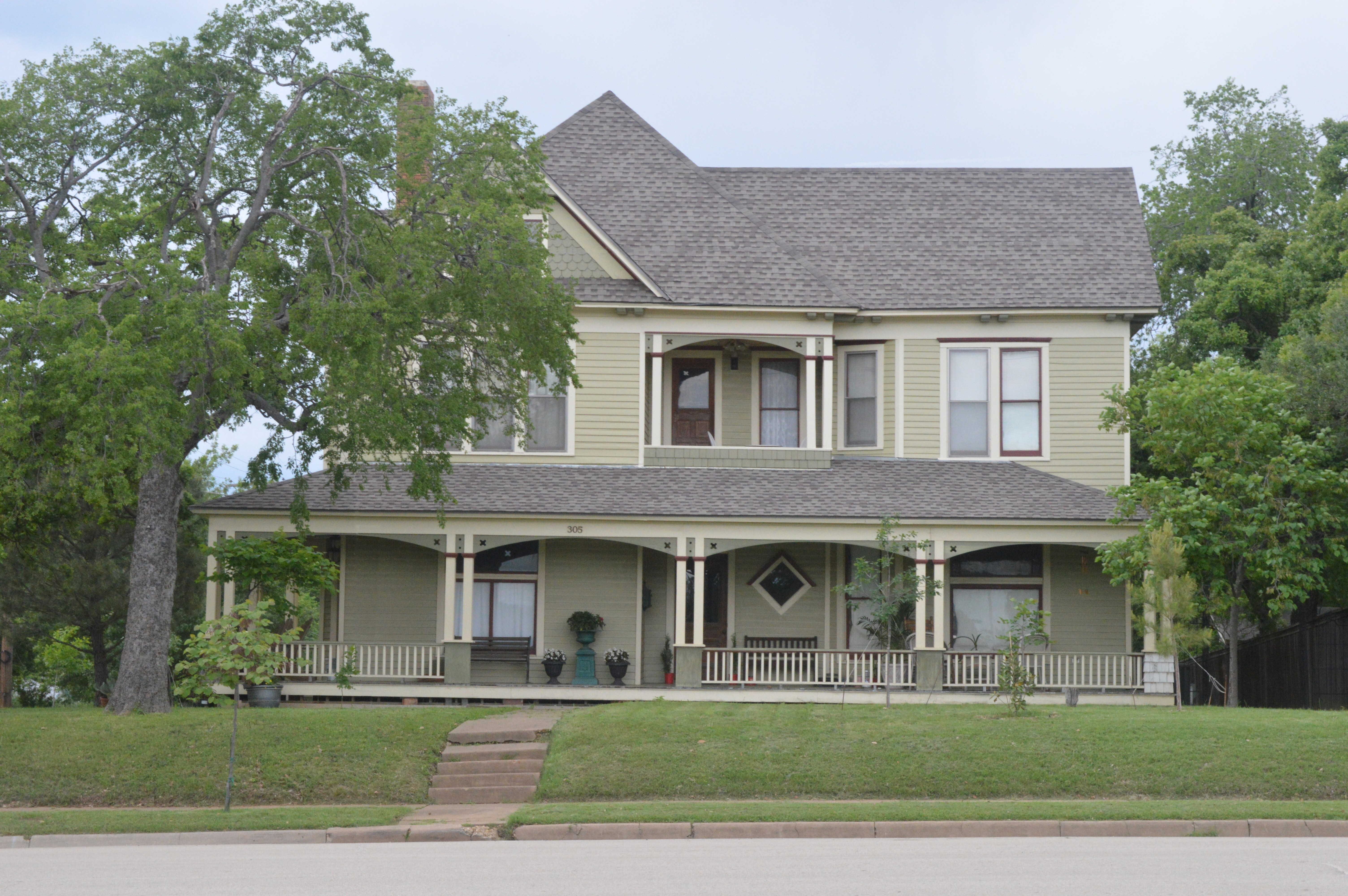


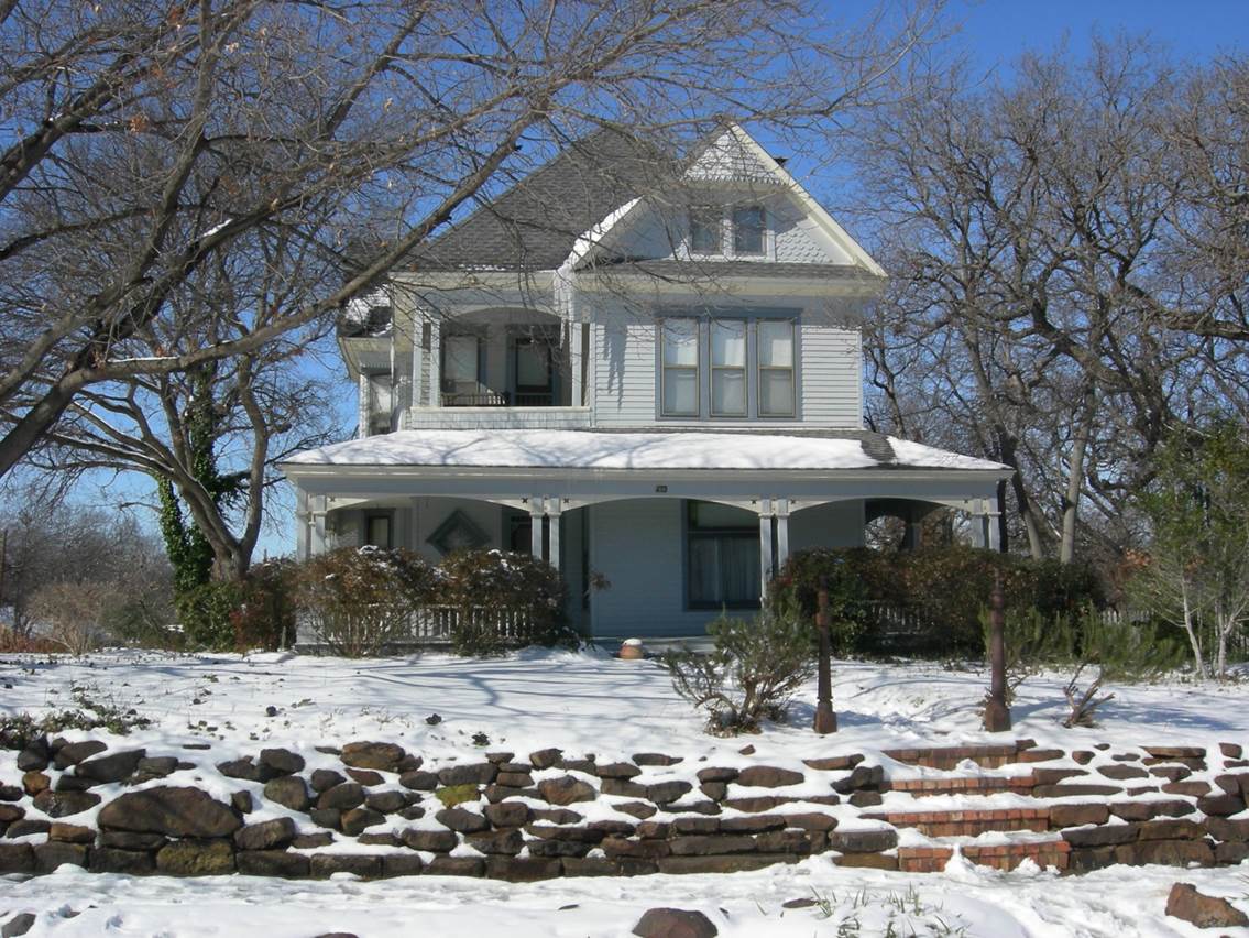
 Denton County.jpg)

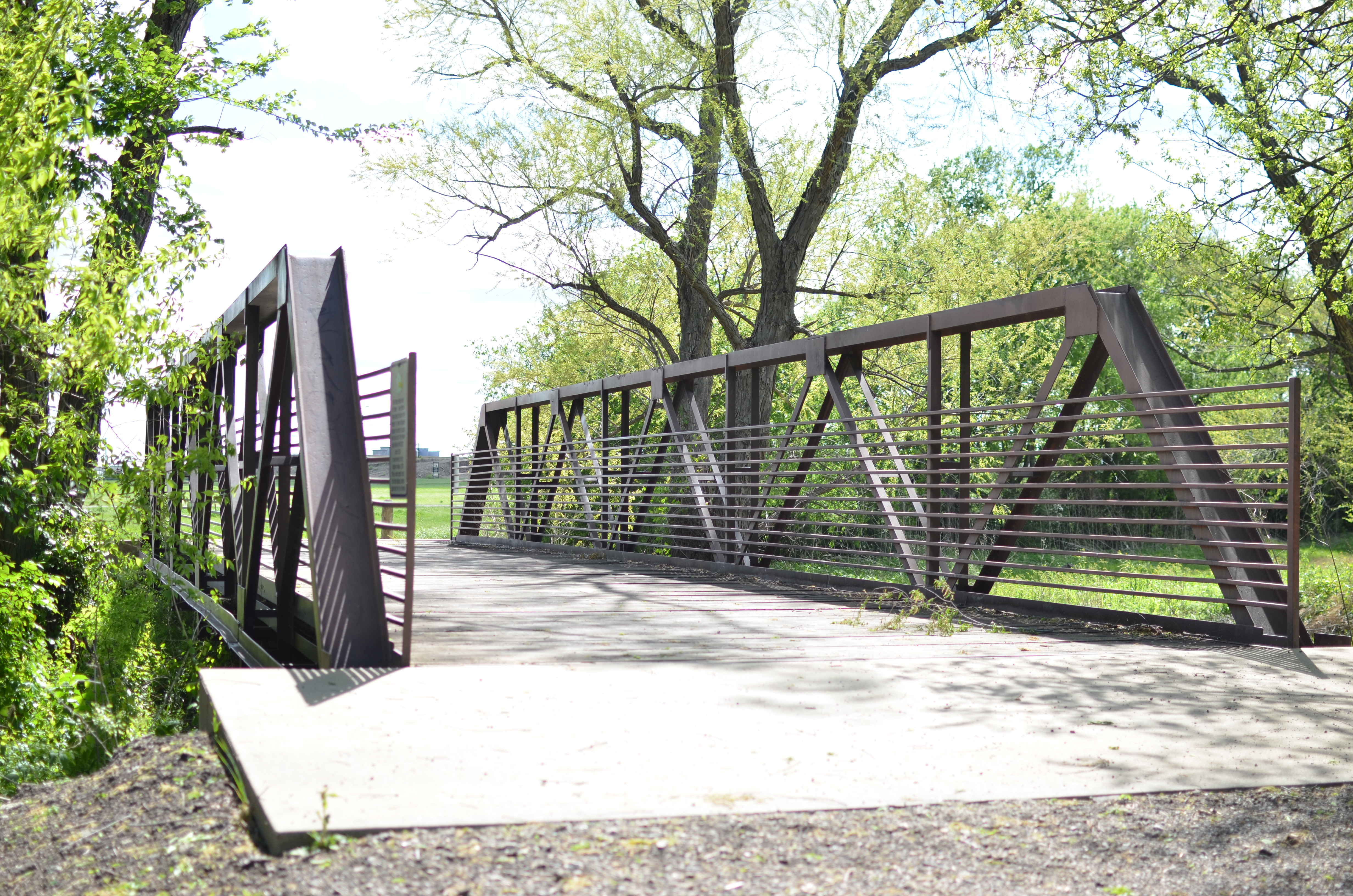
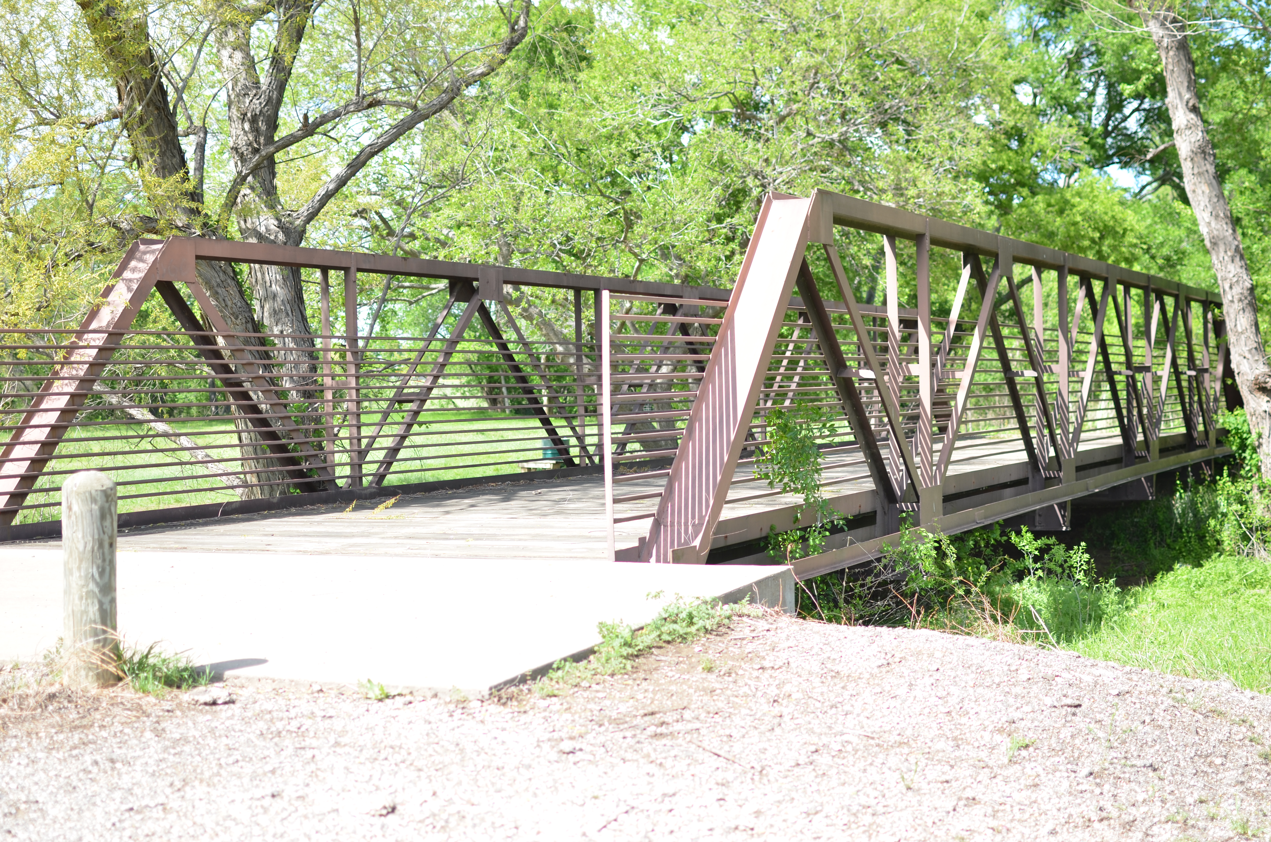
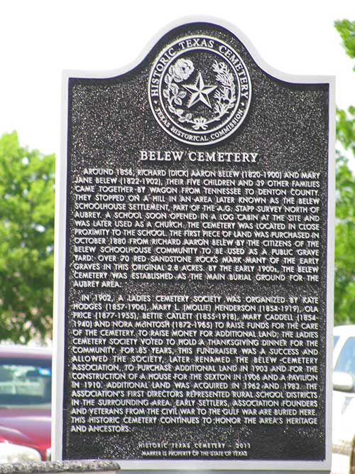
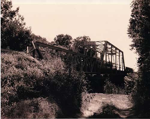

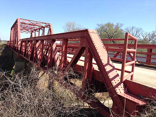
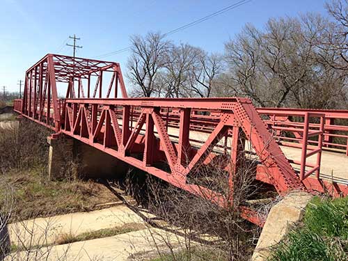
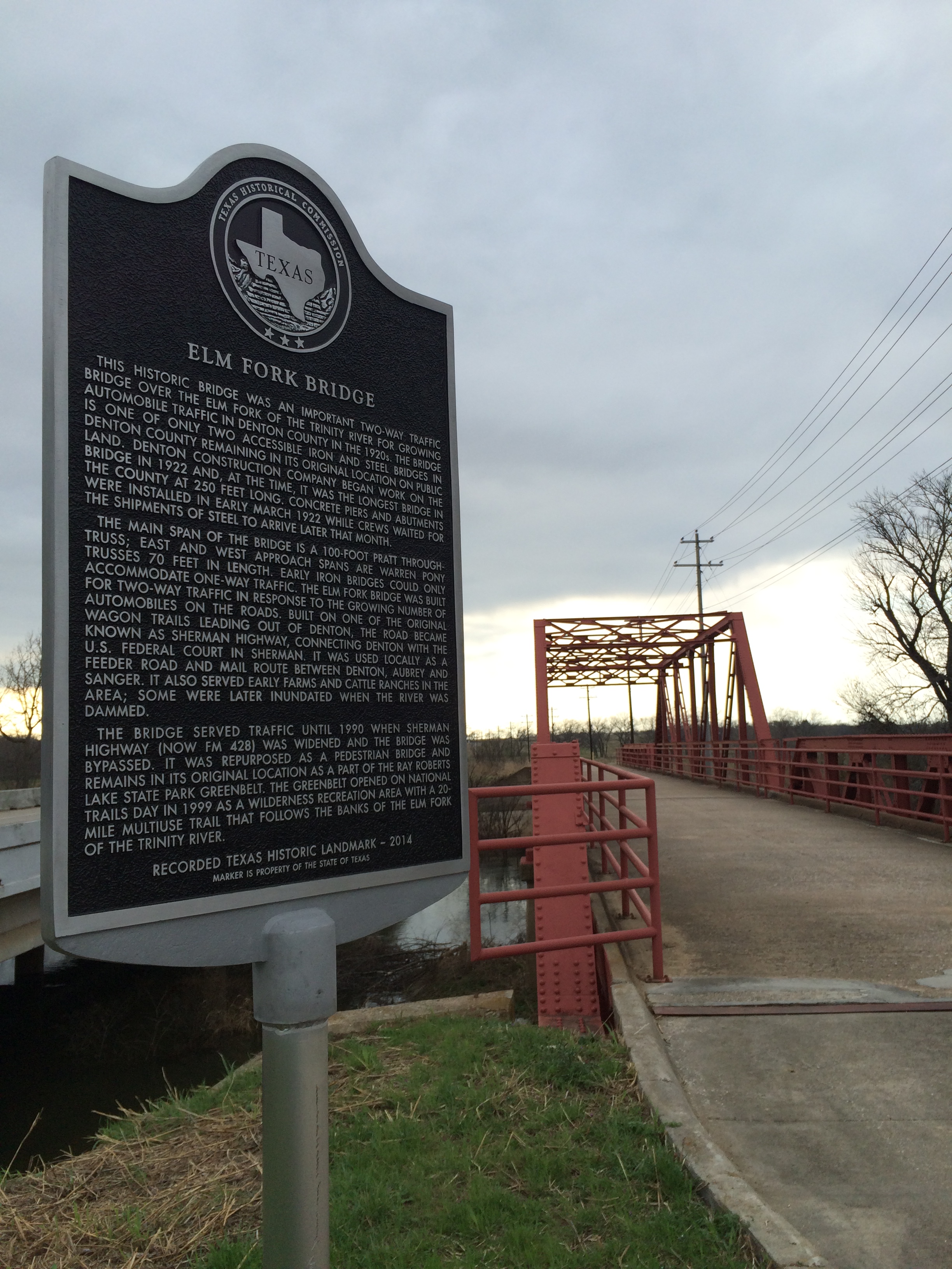
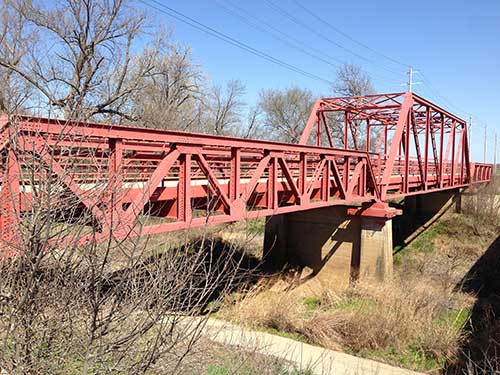
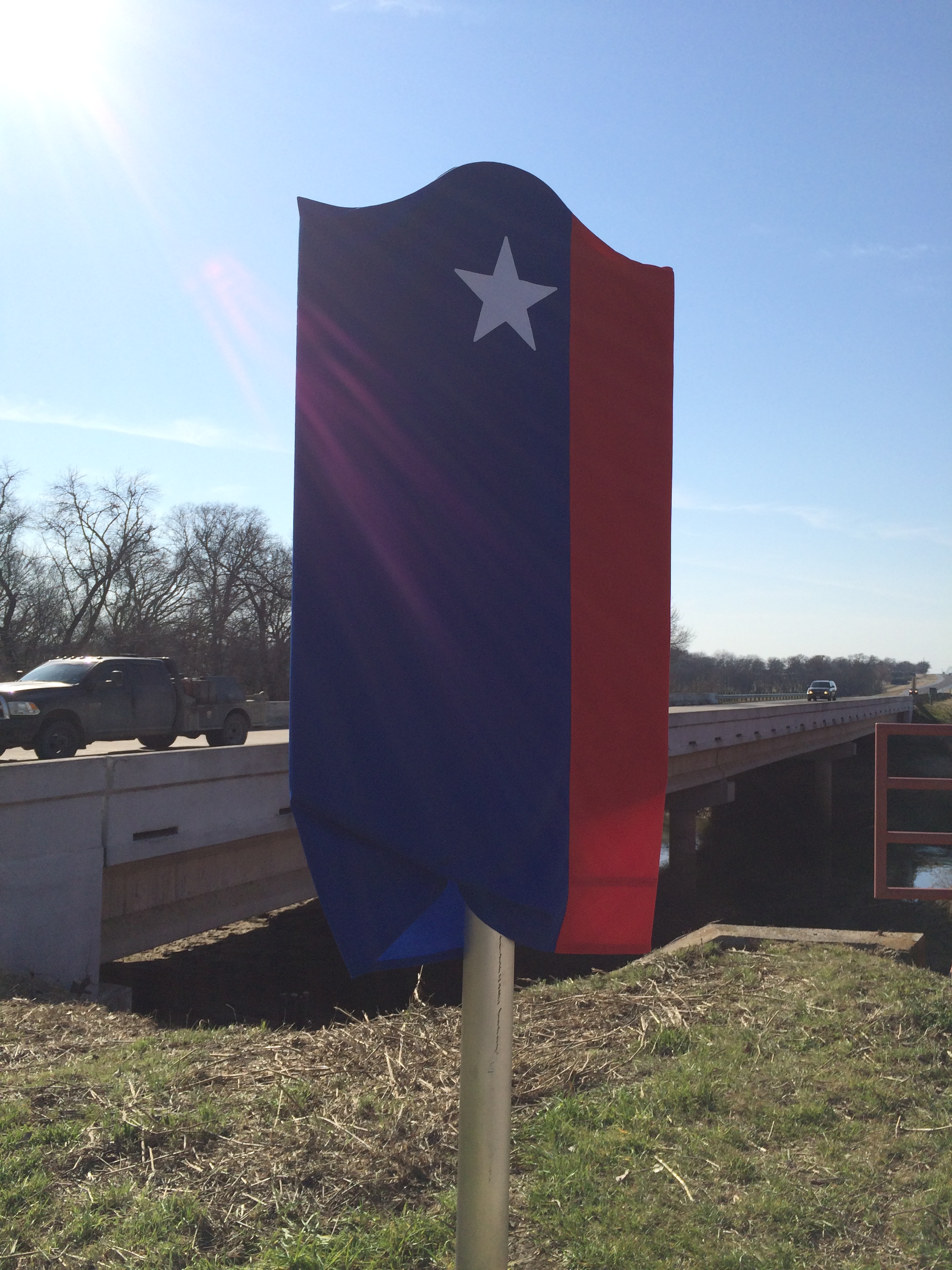
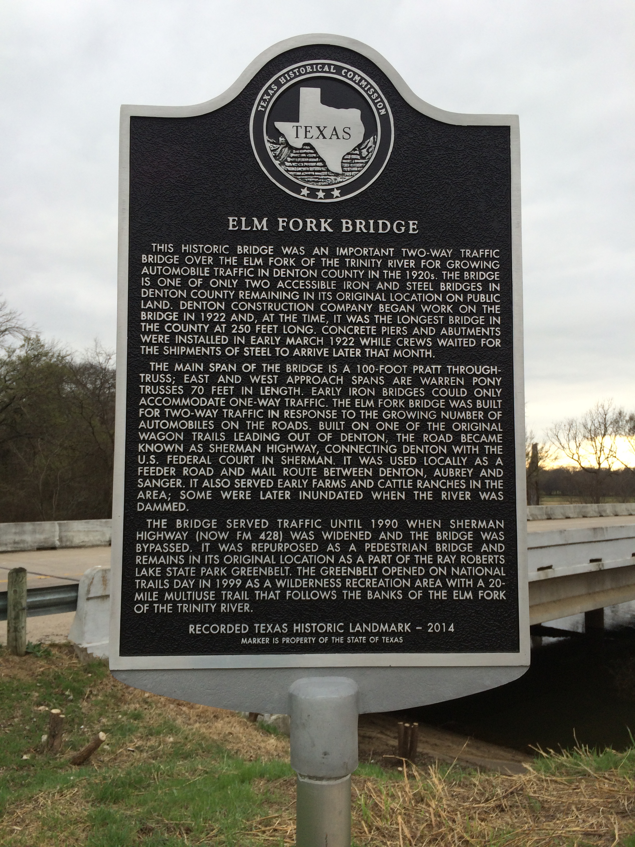
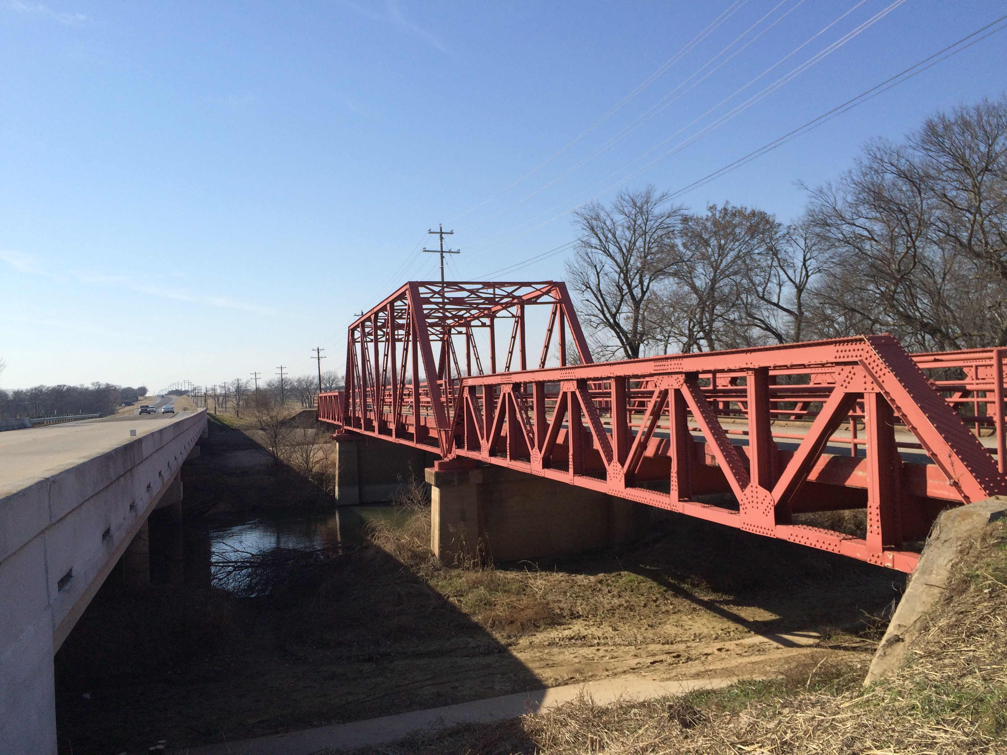

